Maps of Bourgogne-Franche-Comté

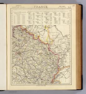
France 2.
1 : 1774080 Letts, Son & Co.
Übersichtskarte des deutsch-französischen Kriegsschauplatzes
1 : 750000 Francie k. u. k. Hof- und Universitätsbuchhandlung R. Lechner (W. Müller)
Übersichtskarte des deutsch-französischen Kriegsschauplatzes
1 : 750000 Francie k. u. k. Hof- und Universitätsbuchhandlung R. Lechner
Carte de la France (NE)
1 : 345600 Cassini family
Der Nordoestliche Theil von Frankreich
Stieler's Hand-Atlas Stieler, Adolf bei Justus Perthes
Reliefkarte von Nordost-Frankreich


Der Nordöstliche Theil von Frankreich
Hand-Atlas über alle Theile der Erde nach dem neuesten Zustande und über das Weltgebäude Stieler, Adolf bei Justus Perthes
France Régionale Bassin de Paris Région du Nord carte physique
Gallois, Lucien
Östreichisch-französischer Kriegsschauplatz
1 : 710000 Evropa západní Schraembl, Franz Anton F. A. Schrämbl
Östreichisch-französischer Kriegsschauplatz
Francie in der Schrämblischen Buchhandlung
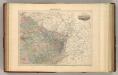
France II.
1 : 1750000 Society for the Diffusion of Useful Knowledge (Great Britain)
Carte de la France, 2
1 Blatt : 60 x 82 cm de Belleyme
Karta dlja ob‘‘jasnenija pervonačal’nych dějstvij vo Francii
Frankreich Befreiungskriege <1813-1815>
Einsatz der 1./Pz. Rgt. 2 im Westen vom 10. 5. - 6. 9. 1940
Francie Veit Carl Kaestner
Pictorial map of the seat of war in Europe
1 : 1
Severovýchodní Francie

Nordost-Frankreich und Belgien
1 : 750000 Belgie Justus Perthes
Karte von Frankreich in XVI Blättern, No. 3 und [No. 7]
2 Blätter : 53 x 34 cm Königl. Preuss. Academischen Kunst und Buchhandlung
Nordost Frankreich, Belgien und Luxemburg Deutsche Rheinländer
Kriegs Atlas 36 Karten von den Schauplätzen des Weltkrieges 1914/1915
France N.E.
1 : 1615000 Migeon, J.
[Frankreich in 4 Blättern, Blatt 2]
Handatlas über alle Theile der Erde und über das Weltgebäude Stieler, Adolf Justus Perthes
France Flle. N.E.
1 : 1000000 Vivien St Martin, L.
Flemmings Spezialkarte für den deutsch-französischen Krieg
1 : 600000 Evropa západní Carl Flemming
The Western Front. June 1918.
1 : 600000 First World War map of the Western Front. June 1918. Front Line June 12th, June 5th and March 20th. War Office
Paasche's Frontenkarte, Nr.14. Der Krieg gegen Russland

Western Front. Front line on March 20th, Aug.16th, Sept. 18th 1918.
1 : 600000 First World War map of the Western Front. Front line on March 20th, Aug.16th, Sept. 18th 1918. Shows limits of German advance in 1918. War Office