Maps of Grand Est

Frankreich NO.
1 : 1700000 Berghaus, Heinrich; Flemming, Carl; Handtke, Friedrich H.; Sohr, Karl
Carte geographique representant le cours entier du Rhin, de la Moselle, de la Meuse et de l'Escaut avec les pays confins specialement l'etat actuel de toutes les possessions de la Maison de l'Autriche dans les Pays Bas et une grande partie de la France / par Matthieu Albert et George Frederic Lotter = Cabinetskarte welche den ganzen Lauff des Rheins, der Mosel, der Maas und Schelde nebst den angraenzenden Laendern vorzüglich alle gegenwaertige Besi[t]zungen des Hauses Oesterreich und einen grossen Theil von Frankreich vorstellt
1 : 400000 titelvariant: Cabinetskarte welche den ganzen Lauff des Rheins, der Mosel, der Maas und Schelde nebst den angraenzenden Laendern vorzüglich alle gegenwaertige Besitzungen des Hauses Oesterreich und einen grossen Theil von Frankreich vorstellt; Annotatie: Titel in handschrift op verso: Cabinetskarte Rhein, Mosel, Maas, Schelde; Annotatie geografische gegevens: West boven Lotter, Mattäus Albrecht; Lotter, Georg Friedrich Augsbourg : Lotter
Carte de la France, 2
1 Blatt : 60 x 82 cm de Belleyme
Übersichtskarte des deutsch-französischen Kriegsschauplatzes
1 : 750000 Francie k. u. k. Hof- und Universitätsbuchhandlung R. Lechner (W. Müller)
Karta dlja ob‘‘jasnenija pervonačal’nych dějstvij vo Francii
Frankreich Befreiungskriege <1813-1815>
Sedes ac theatrvm bellorvm per plurimos annos in Regionibus Rheni, Mosae ac Mosellae
1 : 920000 Alsasko (Francie) Bodenehr, Gabriel Tobias Conrad Lotter
Carte de la République française, 2
1 Blatt : 42 x 51 cm P.G. Chanlaire
Le royaume de France orientale, dit autrement Austrasie
1 Karte : Kupferdruck ; 39 x 49 cm, Bildgrösse 39 x 56 cm Duval chez l'auteur en l'isle du Palais sur le quay de l'Orloge
France II.
1 : 1750000 Society for the Diffusion of Useful Knowledge (Great Britain)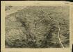
Pictorial map of the seat of war in Europe
1 : 1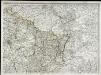
Carte de la France, 2
1 Blatt : 61 x 83 cm de Belleyme
France Régionale France de l’Est Jura-Bassin de la Saône carte politique
Gallois, Lucien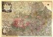
Theatrum Belli Serenissimae Domus Austriacae, Contra Gallos, Confine Limitibus Sacri Romani Imperii et Belgii
1 : 400000 Mollova mapová sbírka Oettinger, Johann Friedrich Lotter, Tobias Conrad Seutter, Matthäus
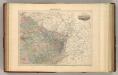
France N.E.
1 : 1615000 Migeon, J.
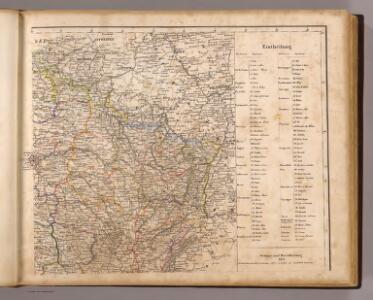
Frankreich In 4 Blattern, Blatt 2.
1 : 1500000 Vogel, C.
France.
1 : 4400000 Vivien de St Martin, L.
[Frankreich in 4 Blättern, Blatt 2]
Handatlas über alle Theile der Erde und über das Weltgebäude Stieler, Adolf Justus Perthes
Reliefkarte von Nordost-Frankreich

Der Nordoestliche Theil von Frankreich
Stieler's Hand-Atlas Stieler, Adolf bei Justus Perthes
Nordost Frankreich, Belgien und Luxemburg Deutsche Rheinländer

Sedes ac Theatrvm Bellorvm per plurimos annos in Inferiori et Superiori Germania gestorum accuratissimâ delineatione oculis exhibitum
1 : 1100000 Mollova mapová sbírka Bodenehr, Gabriel Wolff, Jeremias
Zu den Feldzügen 1708 in den Niederlanden und am Rhein
Lille (Francie) Coxe, William K.k. Generalstabes
Severovýchodní Francie


Fluviorum Rheni Mosae ac Mosellae Novissima Exhibitio
1 : 1100000 Mollova mapová sbírka Schenk, Pieter Schenk, Peter I
Fluviorum Rheni Mosae ac Mosellae novissima exhibitio
1 : 1100000 Alsasko (Francie) Schenk, Pieter Petro Schenk