Maps of Grand Est

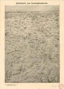
Reliefkarte von Nordost-Frankreich

Nordost-Frankreich und Belgien
1 : 750000 Belgie Justus Perthes
France II.
1 : 1750000 Society for the Diffusion of Useful Knowledge (Great Britain)
Carte de la France (NE)
1 : 345600 Cassini family
Karten des französisch-belgischen Kriegsschaplatzes
1 : 1000000 Belgie Velhagen & Klasing
Paasche's Frontenkarte, Nr.17. Der Krieg gegen Russland

Paasche's Frontenkarte, Nr.14. Der Krieg gegen Russland

Pictorial map of the seat of war in Europe
1 : 1
Le royaume de France, 2
1 Blatt : 60 x 43 cm Jaillot
Übersichtskarte des deutsch-französischen Kriegsschauplatzes
1 : 750000 Francie k. u. k. Hof- und Universitätsbuchhandlung R. Lechner (W. Müller)
Übersichtskarte des deutsch-französischen Kriegsschauplatzes
1 : 750000 Francie k. u. k. Hof- und Universitätsbuchhandlung R. Lechner
Paasche's Frontenkarte, Nr.15. Der Krieg gegen Russland

Neueste und aceurate Landkarte des volligen-Rheinstroms mit den daran gelegenen Landschafften und benachbarten Provinzien, auch einem grossen theil des Franzos: Konigreiches
Mollova mapová sbírka Lerch, Johann Martin Lerch, Johann Martin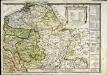
Le royaume de France orientale, dit autrement Austrasie
1 Karte : Kupferdruck ; 39 x 49 cm, Bildgrösse 39 x 56 cm Duval chez l'auteur en l'isle du Palais sur le quay de l'Orloge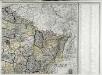
Carte de la France, 2
1 Blatt : 60 x 82 cm de Belleyme

France frontiére Nord-Est et alsace-lorraine
Vidal de La Blache, Paul
[Frankreich, Blatt 2]
Adolf Stieler's Handatlas über alle Theile der Erde und über das Weltgebäude Stieler, Adolf Justus Perthes
Distribution of German forces on the Western Front
1 : 750000 First World War map of the distribution of German forces on the Western Front according to captured map dates 30th Oct. 1918. Title of base sheet 'Map of the Western Theatre of War'. War Office
Paasche's Frontenkarte, Nr.13. Der Krieg gegen Russland

Carte de la République française, 2
1 Blatt : 42 x 51 cm P.G. Chanlaire
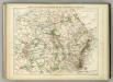
Der Nordöstliche Theil von Frankreich
Hand-Atlas über alle Theile der Erde nach dem neuesten Zustande und über das Weltgebäude Stieler, Adolf bei Justus Perthes
Severovýchodní Francie

Der Nordoestliche Theil von Frankreich
Stieler's Hand-Atlas Stieler, Adolf bei Justus Perthes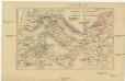
Zur Geschichte von Italien
Belgie R. Gaertner
[Frankreich in 4 Blättern, Nordöstliches Frankreich]
Hand-Atlas über alle Theile der Erde und über das Weltgebäude Stieler, Adolf Justus Perthes
France Régionale Bassin de Paris Région du Nord carte physique
Gallois, Lucien
Paasche's Frontenkarte, Nr.4. Der Krieg gegen Russland