Maps of Grand Est

Carte de la France (NE)
1 : 345600 Cassini family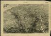
Pictorial map of the seat of war in Europe
1 : 1
Reliefkarte von Nordost-Frankreich

Severovýchodní Francie


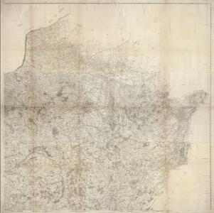
Der Nordöstliche Theil von Frankreich
Hand-Atlas über alle Theile der Erde nach dem neuesten Zustande und über das Weltgebäude Stieler, Adolf bei Justus Perthes
France II.
1 : 1750000 Society for the Diffusion of Useful Knowledge (Great Britain)
Nordost-Frankreich und Belgien
1 : 750000 Belgie Justus Perthes
Der Nordoestliche Theil von Frankreich
Stieler's Hand-Atlas Stieler, Adolf bei Justus Perthes
Übersichtskarte des deutsch-französischen Kriegsschauplatzes
1 : 750000 Francie k. u. k. Hof- und Universitätsbuchhandlung R. Lechner (W. Müller)
Übersichtskarte des deutsch-französischen Kriegsschauplatzes
1 : 750000 Francie k. u. k. Hof- und Universitätsbuchhandlung R. Lechner
V, uit: General-Karte von Mittel-Europa in 12 Blättern, im Masse 1:1.200.000 / entworfen, bearb. und hrsg. von Josef Schlacher
1 : 1200000 Annotatie: Blad 6 ontbreekt; Annotatie geografische gegevens: 21 maatstokken op blad 9; Legenda op blad 9 Wien : K.K. Militär Geografisches Institut
[Frankreich in 4 Blättern, Nordöstliches Frankreich]
Hand-Atlas über alle Theile der Erde und über das Weltgebäude Stieler, Adolf Justus Perthes
Karten des französisch-belgischen Kriegsschaplatzes
1 : 1000000 Belgie Velhagen & Klasing
Carte de la France, 2
1 Blatt : 60 x 82 cm de Belleyme
Paasche's Frontenkarte, Nr.14. Der Krieg gegen Russland

Paasche's Frontenkarte, Nr.17. Der Krieg gegen Russland

France Régionale Bassin de Paris Région du Nord carte physique
Gallois, Lucien

Le royaume de France, 2
1 Blatt : 60 x 43 cm Jaillot
Paasche's Frontenkarte, Nr.15. Der Krieg gegen Russland

Östreichisch-französischer Kriegsschauplatz
1 : 710000 Evropa západní Schraembl, Franz Anton F. A. Schrämbl
Östreichisch-französischer Kriegsschauplatz
Francie in der Schrämblischen Buchhandlung
Carte de la République française, 2
1 Blatt : 42 x 51 cm P.G. Chanlaire
Nordost Frankreich, Belgien und Luxemburg Deutsche Rheinländer

France 2.
1 : 1774080 Letts, Son & Co.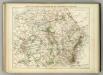
Carte Physique et Militaire de la Frontiere du Nord-Est.
1 : 1000000 Jouvet et Cie.
Distribution of German forces on the Western Front
1 : 750000 First World War map of the distribution of German forces on the Western Front according to captured map dates 30th Oct. 1918. Title of base sheet 'Map of the Western Theatre of War'. War Office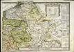
Le royaume de France orientale, dit autrement Austrasie
1 Karte : Kupferdruck ; 39 x 49 cm, Bildgrösse 39 x 56 cm Duval chez l'auteur en l'isle du Palais sur le quay de l'Orloge