Maps of Grand Est

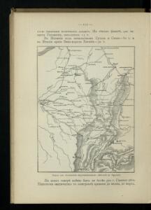
Karta dlja ob‘‘jasnenija pervonačal’nych dějstvij vo Francii
Frankreich Befreiungskriege <1813-1815>
France Régionale France de l’Est Jura-Bassin de la Saône carte politique
Gallois, Lucien

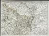
Der Nordoestliche Theil von Frankreich
Stieler's Hand-Atlas Stieler, Adolf bei Justus Perthes

Östreichisch-französischer Kriegsschauplatz
1 : 710000 Evropa západní Schraembl, Franz Anton F. A. Schrämbl
Östreichisch-französischer Kriegsschauplatz
Francie in der Schrämblischen Buchhandlung
France frontiére Nord-Est et alsace-lorraine
Vidal de La Blache, Paul
Der Nordöstliche Theil von Frankreich
Hand-Atlas über alle Theile der Erde nach dem neuesten Zustande und über das Weltgebäude Stieler, Adolf bei Justus Perthes
Übersichtskarte des deutsch-französischen Kriegsschauplatzes
1 : 750000 Francie k. u. k. Hof- und Universitätsbuchhandlung R. Lechner (W. Müller)
Übersichtskarte des deutsch-französischen Kriegsschauplatzes
1 : 750000 Francie k. u. k. Hof- und Universitätsbuchhandlung R. Lechner
France II.
1 : 1750000 Society for the Diffusion of Useful Knowledge (Great Britain)
[Frankreich in 4 Blättern, Nordöstliches Frankreich]
Hand-Atlas über alle Theile der Erde und über das Weltgebäude Stieler, Adolf Justus Perthes
France Régionale France de l’Est Jura-Bassin de la Saône carte physique
Gallois, Lucien
Übersichtskarte des deutsch-französischen Kriegsschauplatzes
1 : 750000 Francie k. u. k. Hof- und Universitätsbuchhandlung R. Lechner (W. Müller)
[Frankreich, Blatt 2]
Adolf Stieler's Handatlas über alle Theile der Erde und über das Weltgebäude Stieler, Adolf Justus Perthes
V, uit: General-Karte von Mittel-Europa in 12 Blättern, im Masse 1:1.200.000 / entworfen, bearb. und hrsg. von Josef Schlacher
1 : 1200000 Annotatie: Blad 6 ontbreekt; Annotatie geografische gegevens: 21 maatstokken op blad 9; Legenda op blad 9 Wien : K.K. Militär Geografisches Institut
Carte de la France, 2
1 Blatt : 60 x 82 cm de Belleyme
Neueste und aceurate Landkarte des volligen-Rheinstroms mit den daran gelegenen Landschafften und benachbarten Provinzien, auch einem grossen theil des Franzos: Konigreiches
Mollova mapová sbírka Lerch, Johann Martin Lerch, Johann Martin

Carte de la République française, 2
1 Blatt : 42 x 51 cm P.G. Chanlaire
[Frankreich in 4 Blättern, Blatt 2]
Handatlas über alle Theile der Erde und über das Weltgebäude Stieler, Adolf Justus Perthes
RHENI TRICORNIS ET WIDI NOVA ET GERMANA DESCRIPTIO, ADDITIS FLVMINIBVS ELECTORVM PROvinciis, Ducatibus, Comitatibus, Oppidis praecipué & Castris ad vivum repraesentatis
1 : 630000 Rýn (řeka : oblast) Bry, Theodor de a Theodoro de Bry Leodiensi
Pictorial map of the seat of war in Europe
1 : 1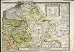
Le royaume de France orientale, dit autrement Austrasie
1 Karte : Kupferdruck ; 39 x 49 cm, Bildgrösse 39 x 56 cm Duval chez l'auteur en l'isle du Palais sur le quay de l'Orloge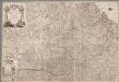
Carte geographique representant le cours entier du Rhin, de la Moselle, de la Meuse et de l'Escaut avec les pays confins specialement l'etat actuel de toutes les possessions de la Maison de l'Autriche dans les Pays Bas et une grande partie de la France / par Matthieu Albert et George Frederic Lotter = Cabinetskarte welche den ganzen Lauff des Rheins, der Mosel, der Maas und Schelde nebst den angraenzenden Laendern vorzüglich alle gegenwaertige Besi[t]zungen des Hauses Oesterreich und einen grossen Theil von Frankreich vorstellt
1 : 400000 titelvariant: Cabinetskarte welche den ganzen Lauff des Rheins, der Mosel, der Maas und Schelde nebst den angraenzenden Laendern vorzüglich alle gegenwaertige Besitzungen des Hauses Oesterreich und einen grossen Theil von Frankreich vorstellt; Annotatie: Titel in handschrift op verso: Cabinetskarte Rhein, Mosel, Maas, Schelde; Annotatie geografische gegevens: West boven Lotter, Mattäus Albrecht; Lotter, Georg Friedrich Augsbourg : Lotter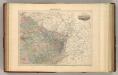
France N.E.
1 : 1615000 Migeon, J.
Nordost Frankreich, Belgien und Luxemburg Deutsche Rheinländer
Carte de la France, 2
1 Blatt : 61 x 83 cm de Belleyme