Maps of Grand Est

Neueste und aceurate Landkarte des volligen-Rheinstroms mit den daran gelegenen Landschafften und benachbarten Provinzien, auch einem grossen theil des Franzos: Konigreiches
Mollova mapová sbírka Lerch, Johann Martin Lerch, Johann Martin
[Frankreich, Blatt 2]
Adolf Stieler's Handatlas über alle Theile der Erde und über das Weltgebäude Stieler, Adolf Justus Perthes
[Frankreich in 4 Blättern, Nordöstliches Frankreich]
Hand-Atlas über alle Theile der Erde und über das Weltgebäude Stieler, Adolf Justus Perthes
Frankreich. Upper right sheet
1 : 1200000 Geographisches Institut (Weimar, Germany)
Carte de la France, 2
2 Blätter : mehrfarbig ; 71 x 83 cm de Belleyme
Germania Parte Occidentale
1 : 2100000 Mollova mapová sbírka Coronelli, Vincenzo Maria
Germania Parte Occidentale
1 : 2100000 Mollova mapová sbírka Coronelli, Vincenzo Maria
France frontiére Nord-Est et alsace-lorraine
Vidal de La Blache, Paul
France II.
1 : 1750000 Society for the Diffusion of Useful Knowledge (Great Britain)
Carte des principaux points du théatre de la guerre présente sur le frontieres d'Allemagne et de Pays-Bas
1 : 2200000 Francie Bouge, Jean-Baptiste de chez J. B. de Bouge
Nejnovější mapa bojiště německo - francouzského
Le royaume de France orientale, dit autrement Austrasie
1 Karte : Kupferdruck ; 39 x 49 cm, Bildgrösse 39 x 56 cm Duval chez l'auteur en l'isle du Palais sur le quay de l'Orloge
Carte de la République française, 2
1 Blatt : 42 x 51 cm P.G. Chanlaire
Territory in Western Germany occupied by the Allied Armies
1 : 1000000 First World War map of the territory in Western Germany occupied by the Allied Armies and the stages of evacuation according to article 429 of the peace treaty. Situation for July 1921. War Office
Belgica oder Nieder Teutschland
Belgie Baumgarten, Siegmund Jakob Johann Justinus Gebauer
France.
1 : 4400000 Vivien de St Martin, L.
Carte de la France, 2
1 Blatt : 61 x 83 cm de Belleyme
Belli ab obitu Caroli VI. Imperatoris usqve ad pacem Dresdae d. 25. Dec. MDCCXLV
1 : 1300000 Mollova mapová sbírka Kraus, Lorenz Jacob Homann, Johann Baptista - dědici
Kriegs - Karte 1870
Skizze zur Orientirung ϋber den Feldzug 1795

[Frankreich in 4 Blättern, Blatt 2]
Handatlas über alle Theile der Erde und über das Weltgebäude Stieler, Adolf Justus Perthes
Sedes ac Theatrvm Bellorvm per plurimos annos in Regionibus Rheni, Mosae ac Mosellae adjacentibus
Lotter, Tobias Conrad; Bodenehr, Gabriel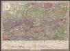
Le Cours De La Riviere Du Rhein depuis sa Source jusques a son Emboucheure [...] [Karte], in: Atlas nouveau, contenant toutes les parties du monde [...], Bd. 1, S. 166.
1 Karte aus Atlas Sanson, Nicolas Jaillot, Alexis Hubert und Mortier, Pieter
Frankreich In 4 Blattern, Blatt 2.
1 : 1500000 Vogel, C.
Kriegs-Karte 1870
1 : 1000000 Belgie Eduard Hallberger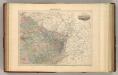
France N.E.
1 : 1615000 Migeon, J.
Carte des peuples riverains du Rhin au temps d’Auguste et de ses successeurs immédiats
Mitteleuropa Rhein-Gebiet ethnische Gruppe Germanen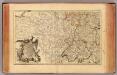
L'Alemagne 3.
1 : 1800000 Rizzi Zannoni, Giovanni Antonio Bartolomeo, 1736-1814
Tabula geographica qua pars septentrionalis sive Inferior Rheni, Mosae, et Mosellae, maximaeque partes Visurgis, Moeni, Amasi, Scaldis, Isalae, et alia in eosdem inluentia flumina, nec non provinciae Germaniae inferioris, Westphaliae, Hassiae, archiepiscopatus et electoratus Coloniensis ac Trevirensis, cum partibus Moguntini, et Palatinus Rheni, et aliae regiones adjacentes
1 : 1000000 accuratissime ostenduntur per Nicolaum Visscher Amst. Bat. Amst[elodami] Bat[avorum] : nunc apud Petrum Schenk Jun.