Maps of Grand Est


Östreichisch-französischer Kriegsschauplatz
1 : 710000 Evropa západní Schraembl, Franz Anton F. A. Schrämbl
Östreichisch-französischer Kriegsschauplatz
Francie in der Schrämblischen Buchhandlung
Nejnovější mapa bojiště německo - francouzského

France Régionale France de l’Est Jura-Bassin de la Saône carte physique
Gallois, Lucien
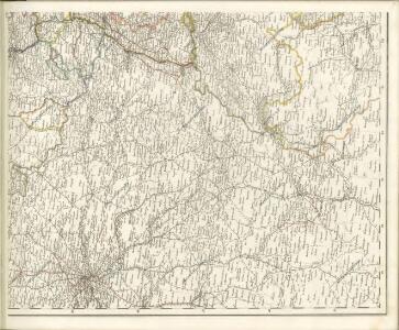
Der Nordöstliche Theil von Frankreich
Hand-Atlas über alle Theile der Erde nach dem neuesten Zustande und über das Weltgebäude Stieler, Adolf bei Justus Perthes
Der Nordoestliche Theil von Frankreich
Stieler's Hand-Atlas Stieler, Adolf bei Justus Perthes
France Régionale France de l’Est Jura-Bassin de la Saône carte politique
Gallois, Lucien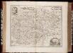
Comitatus Burgundiae, ou la Franche Comté / [Joannes Janssonius]
1 : 650000 Annotatie: Oorspr. verschenen in: Joannis Janssonii Atlantis majori ... - Amstelodami : apud Ioannem Ianssonium, 1675; Origineel is Blad 20 in atlas factice; Annotatie geografische gegevens: Zuidoost boven Janssonius, Joannes (jr.) (1588-1664) Amstelodami : sumptibus Ioannis Ianssonii

Karta dlja ob‘‘jasnenija pervonačal’nych dějstvij vo Francii
Frankreich Befreiungskriege <1813-1815>
V, uit: General-Karte von Mittel-Europa in 12 Blättern, im Masse 1:1.200.000 / entworfen, bearb. und hrsg. von Josef Schlacher
1 : 1200000 Annotatie: Blad 6 ontbreekt; Annotatie geografische gegevens: 21 maatstokken op blad 9; Legenda op blad 9 Wien : K.K. Militär Geografisches Institut
France frontiére Nord-Est et alsace-lorraine
Vidal de La Blache, Paul
[Helvetien]
1 : 3100000 1 Karte entworfen von F.L. Güssefeld ; gestochen von J.C. Müller [im Verlage des Industrie Comptoirs], [Weimar]
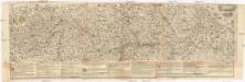
Übersichtskarte des deutsch-französischen Kriegsschauplatzes
1 : 750000 Francie k. u. k. Hof- und Universitätsbuchhandlung R. Lechner (W. Müller)
Übersichtskarte des deutsch-französischen Kriegsschauplatzes
1 : 750000 Francie k. u. k. Hof- und Universitätsbuchhandlung R. Lechner
Galliæ antiquæ descriptio geographica, 4
1 Blatt : 42 x 57 cm s.n.
[Frankreich in 4 Blättern, Nordöstliches Frankreich]
Hand-Atlas über alle Theile der Erde und über das Weltgebäude Stieler, Adolf Justus Perthes
L'Empire, d'Allemagne
1 : 1200000 Mollova mapová sbírka Sanson, Nicolas Quasy, Robert
Nova et Accuratißima Galliae Tabula, Vulgo Royaume De France
1 : 920000 Mollova mapová sbírka Danckerts, Justus Danckerts, Justus
Il Corso Del Fivme Reno :
Mollova mapová sbírka Cantelli, Giacomo Barbey, Antonio De Rossi, Giovanni Giacomo
Postarum seu Veredariorum Stationes Per Germaniam et Provincias Adiacentes.
1 : 400000 Mollova mapová sbírka Danckerts, Justus Danckerts, Cornelis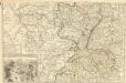
Theatre de la Guerre en Allemagne et dans les Pays Bas.
1 : 1100000 Mollova mapová sbírka Nolin, Jean-Baptiste Nolin, Jean-Baptiste I.
[Frankreich, Blatt 2]
Adolf Stieler's Handatlas über alle Theile der Erde und über das Weltgebäude Stieler, Adolf Justus Perthes
France II.
1 : 1750000 Society for the Diffusion of Useful Knowledge (Great Britain)
Übersichtskarte des deutsch-französischen Kriegsschauplatzes
1 : 750000 Francie k. u. k. Hof- und Universitätsbuchhandlung R. Lechner (W. Müller)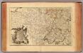
L'Alemagne 3.
1 : 1800000 Rizzi Zannoni, Giovanni Antonio Bartolomeo, 1736-1814
Neueste und aceurate Landkarte des volligen-Rheinstroms mit den daran gelegenen Landschafften und benachbarten Provinzien, auch einem grossen theil des Franzos: Konigreiches
Mollova mapová sbírka Lerch, Johann Martin Lerch, Johann Martin