Maps of Grand Est
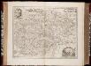
Comitatus Burgundiae, ou la Franche Comté / [Joannes Janssonius]
1 : 650000 Annotatie: Oorspr. verschenen in: Joannis Janssonii Atlantis majori ... - Amstelodami : apud Ioannem Ianssonium, 1675; Origineel is Blad 20 in atlas factice; Annotatie geografische gegevens: Zuidoost boven Janssonius, Joannes (jr.) (1588-1664) Amstelodami : sumptibus Ioannis Ianssonii

France Régionale France de l’Est Jura-Bassin de la Saône carte physique
Gallois, Lucien
RHENI TRICORNIS ET WIDI NOVA ET GERMANA DESCRIPTIO, ADDITIS FLVMINIBVS ELECTORVM PROvinciis, Ducatibus, Comitatibus, Oppidis praecipué & Castris ad vivum repraesentatis
1 : 630000 Rýn (řeka : oblast) Bry, Theodor de a Theodoro de Bry Leodiensi
France Régionale France de l’Est Jura-Bassin de la Saône carte politique
Gallois, Lucien
Östreichisch-französischer Kriegsschauplatz
1 : 710000 Evropa západní Schraembl, Franz Anton F. A. Schrämbl
Östreichisch-französischer Kriegsschauplatz
Francie in der Schrämblischen Buchhandlung
Assemblage de l' atlas Suisse.
From Atlas Suisse. Levé et dessiné par J. H. Weiss aux fraix de J. R. Meyer á Aarau dans les années 1786 á 1802. Gravée par Guerin, Eichler, et Scheurmann.
L'Empire, d'Allemagne
1 : 1200000 Mollova mapová sbírka Sanson, Nicolas Quasy, Robert
Il Corso Del Fivme Reno :
Mollova mapová sbírka Cantelli, Giacomo Barbey, Antonio De Rossi, Giovanni Giacomo
Galliæ antiquæ descriptio geographica, 4
1 Blatt : 42 x 57 cm s.n.
Postarum seu Veredariorum Stationes Per Germaniam et Provincias Adiacentes.
1 : 400000 Mollova mapová sbírka Danckerts, Justus Danckerts, Cornelis
Übersichtskarte des deutsch-französischen Kriegsschauplatzes
1 : 750000 Francie k. u. k. Hof- und Universitätsbuchhandlung R. Lechner (W. Müller)
Le Cours de la Riviere du Rhein
1 : 1100000 Mollova mapová sbírka Sanson, Guillaume Mortier, Pierre
Accuratissima Rheni superioris Mosae et Mosellae tabula ac minores in eosdem influentes fluvii
1 : 950000 1 Karte : Kupferdruck ; 49 x 57 cm Danckerts, Theodorus [Danckerts]
Le Cours de la Riviere du Rhein
1 : 1100000 Mollova mapová sbírka Sanson, Guillaume Schenk, Peter I
Uebersichtskarte der Schweiz mit ihren Grenzgebieten / gez. u. gest. von R. Leuzinger ; Schrift C. v. Hoven
1 : 1000000 titelvariant: Uebersichtskarte der Schweiz; Annotatie: Oorspr. uitg.: [S.l.] : Eidg. Stadsbureau, 1878 R. Leuzinger; C. v. Hoven [S.l. : s.n.]
Uebersichtskarte der Schweiz mit ihren Grenzgebieten / gez. u. gest. von R. Leuzinger ; Schrift C. v. Hoven
1 : 1000000 titelvariant: Uebersichtskarte der Schweiz; Annotatie: Oorspr. uitg.: [S.l.] : Eidg. topogr. Bureau, 1878 R. Leuzinger; C. v. Hoven [S.l. : s.n.] / (Bern : Kümmerly & Frey)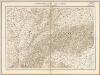
Uebersichtskarte der Schweiz mit ihren Grenzgebieten / gez. u. gest. von R. Leuzinger ; Schrift C. v. Hoven
1 : 1000000 titelvariant: Uebersichtskarte der Schweiz; Annotatie: Oorspr. uitg.: [S.l.] : Eidg. topogr. Bureau, 1878 R. Leuzinger; C. v. Hoven [S.l. : s.n.] / (Bern : Kümmerly & Frey)
Uebersichtskarte der Schweiz mit ihren Grenzgebieten
1 : 1000000 Leuzinger, Rudolf ; Hoven, Georg Christian von Eidg. Stabsbureau
Uebersichtskarte der Schweiz mit ihren Grenzgebieten
1 : 1000000 Leuzinger, Rudolf Eidg. Stabsbureau
Karta dlja ob‘‘jasnenija pervonačal’nych dějstvij vo Francii
Frankreich Befreiungskriege <1813-1815>
Der Nordöstliche Theil von Frankreich
Hand-Atlas über alle Theile der Erde nach dem neuesten Zustande und über das Weltgebäude Stieler, Adolf bei Justus Perthes
Nova et Accuratißima Galliae Tabula, Vulgo Royaume De France
1 : 920000 Mollova mapová sbírka Danckerts, Justus Danckerts, Justus
Provincia maxima Sequanorum cum vicinis
1 Karte : Kupferdruck ; 19 x 29 cm s.n.
[Deutschland und der gröste Theil der umliegenden Staaten oder Mittel-Europa]
1 : 1100000 35 Karten [nach astronomischen Ortsbestimmungen und den besten Special-Karten, mit Rücksicht auf die neuesten Grenz-Bestimmungen entworfen, zufolge der Wiener Congress-Akte, des Pariser Friedens vom 21ten Nov. 1815, und der neuesten Austauschungen 1816 von H.H. Gotthold] ; [geschrieben und gestochen von H. Kliewer] ; sämtliche Gebürge im Atlas sind gezeichnet und gestochen von Paulus Schmidt, so wie auch die Sectionen 3,11,16,18,19,21,25,26,31 von demselben gestochen worden [Simon Schropp & Co.], [Berlin]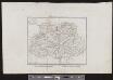
Elvezia, o, Paese de'Svizzeri
1 : 1500000 1 Karte Giovanni di Pietro incise [Batelli e Fanfani], [Milano]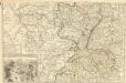
Theatre de la Guerre en Allemagne et dans les Pays Bas.
1 : 1100000 Mollova mapová sbírka Nolin, Jean-Baptiste Nolin, Jean-Baptiste I.
Tabula Geographica qua Pars Meridionalis sive Superior Rheni, Mosae et Mosellae
1 : 1100000 Mollova mapová sbírka Visscher, Nicolaes Jansz. Visscher, Nicolaus
![Comitatus Burgundiae, ou la Franche Comté / [Joannes Janssonius]](https://images-2.georeferencer.com/images/iiif/193014061355/full/,300/0/native.jpg)

