Maps of Grand Est

Paasche's Frontenkarte, Nr.17. Der Krieg gegen Russland

Paasche's Frontenkarte, Nr.15. Der Krieg gegen Russland

Paasche's Frontenkarte, Nr.14. Der Krieg gegen Russland

Paasche's Frontenkarte, Nr.13. Der Krieg gegen Russland

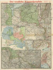
Distribution of German forces on the Western Front
1 : 750000 First World War map of the distribution of German forces on the Western Front according to captured map dates 30th Oct. 1918. Title of base sheet 'Map of the Western Theatre of War'. War Office
Paasche's Frontenkarte, Nr.4. Der Krieg gegen Russland

Nordost-Frankreich und Belgien
1 : 750000 Belgie Justus Perthes
Reliefkarte von Nordost-Frankreich
Carte Physique et Militaire de la Frontiere du Nord-Est.
1 : 1000000 Jouvet et Cie.
France II.
1 : 1750000 Society for the Diffusion of Useful Knowledge (Great Britain)
Carte de la France (NE)
1 : 345600 Cassini family
Map Western Front.
1 : 633600 C.S. Hammond & Company
Karten des französisch-belgischen Kriegsschaplatzes
1 : 1000000 Belgie Velhagen & Klasing
67-68. North-East France, Belgium, Luxemburg. The World Atlas.
1 : 1250000 USSR (Union of Soviet Socialist Republics).
Pictorial map of the seat of war in Europe
1 : 1
Le royaume de France, 2
1 Blatt : 60 x 43 cm Jaillot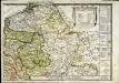
Le royaume de France orientale, dit autrement Austrasie
1 Karte : Kupferdruck ; 39 x 49 cm, Bildgrösse 39 x 56 cm Duval chez l'auteur en l'isle du Palais sur le quay de l'Orloge
Skizze zur Orientirung ϋber den Feldzug 1795

Severovýchodní Francie

Allgemeine Uebersicht des Kriegsschauplazes am Rhein, der Mosel, Maas, Marne, Seine, Schelde [et].c.c
1 Karte : Kupferdruck ; 48 x 58 cm Güssefeld bey d. Homann. Erben
France Flle. N.E.
1 : 1000000 Vivien St Martin, L.
Western Front. Front line on March 20th, Aug.16th, Sept. 18th 1918.
1 : 600000 First World War map of the Western Front. Front line on March 20th, Aug.16th, Sept. 18th 1918. Shows limits of German advance in 1918. War Office
Skizze zur Orientirung ϋber den Feldzug 1807

Kriegsschauplatz oder Graenzkarte zwischen Deutschland u. Frankreich enthaltend die Oesterreichische Niederlanden, das Bisthum Lüttich, Chur Cöln, Trier, Maynz, und Pfaltz, Ober, und Chur Rhein, Fränkischer, und Schwäbisher Kreis, einen Theil von Westphalen, Hessen, Cassel, Darmstadt, und Zweybrücken nebst Breisgau, das Französische Flandern, Artois, Henegau, Picardie, Isle de France mit Paris, Champagne, Lothringen und Elsas
1 : 680000 Alsasko (Francie) Ioh. Walch
Kriegsschauplatz oder Graenzkarte zwischen Deutschland u. Franckreich
1 : 680000 Alsasko (Francie) Walch, Johann bey Joh. Walch
Kriegstheater oder Graenzkarte zwischen Deutschland und Frankreich
1 : 500000 Belgie
Kriegsschauplatz oder Graenzkarte zwischen Deutschland u. Frankreich enthaltend die Oesterreichische Niederlanden, das Bisthum Lüttich, Chur Cöln, Trier, Maynz, und Pfaltz, Ober, und Chur Rhein, Fränkischer, und Schwäbisher Kreis, einen Theil von Westphalen, Hessen, Cassel, Darmstadt, und Zweybrücken nebst Breisgau, das Französische Flandern, Artois, Henegau, Picardie, Isle de France mit Paris, Champagne, Lothringen und Elsas
1 : 680000 Alsasko (Francie) Ioh. Walch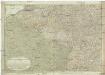
Kriegstheater oder Graenzkarte zwischen Deutschland und Frankreich
1 : 660000 Alsasko (Francie) Müller, Franz Artaria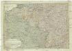
Kriegstheater oder Graenzkarte zwischen Deutschland und Frankreich
1 : 1015000 Evropa západní Müller, Franz bey Artaria