Maps of Grand Est

Paasche's Frontenkarte, Nr.4. Der Krieg gegen Russland

Paasche's Frontenkarte, Nr.13. Der Krieg gegen Russland

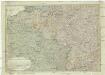
Nordost-Frankreich und Belgien
1 : 750000 Belgie Justus Perthes
Paasche's Frontenkarte, Nr.17. Der Krieg gegen Russland

Paasche's Frontenkarte, Nr.15. Der Krieg gegen Russland

Paasche's Frontenkarte, Nr.14. Der Krieg gegen Russland

67-68. North-East France, Belgium, Luxemburg. The World Atlas.
1 : 1250000 USSR (Union of Soviet Socialist Republics).
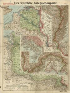
Karten des französisch-belgischen Kriegsschaplatzes
1 : 1000000 Belgie Velhagen & Klasing
Distribution of German forces on the Western Front
1 : 750000 First World War map of the distribution of German forces on the Western Front according to captured map dates 30th Oct. 1918. Title of base sheet 'Map of the Western Theatre of War'. War Office
Reliefkarte von Nordost-Frankreich
Carte Physique et Militaire de la Frontiere du Nord-Est.
1 : 1000000 Jouvet et Cie.
Le royaume de France, 2
1 Blatt : 60 x 43 cm Jaillot
Map Western Front.
1 : 633600 C.S. Hammond & Company
Western Front. Front line on March 20th, Aug.16th, Sept. 18th 1918.
1 : 600000 First World War map of the Western Front. Front line on March 20th, Aug.16th, Sept. 18th 1918. Shows limits of German advance in 1918. War Office
Gallia Belgica et Germania Vtraqve Cisrhenana Svperior et Inferior excvsa
1 : 26000000 Mollova mapová sbírka Weigel, Christoph Weigel, Christoph I.
The Western Front. June 1918.
1 : 600000 First World War map of the Western Front. June 1918. Front Line June 12th, June 5th and March 20th. War Office
Severovýchodní Francie

Map of the Seat of War in France.
1 : 2600000 Carey, Mathew
Map of the Seat of War in France, with the Country divided into its Several Departments.
1 : 2700000 Carey, Mathew
Map of the Seat of War in France, with the Country divided into its Several Departments.
1 : 2700000 Carey, Mathew
France Régionale Bassin de Paris Région du Nord carte physique
Gallois, Lucien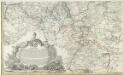
Kriegs Expeditions Karte von Devtschland
1 : 1700000 Mollova mapová sbírka Rizzi Zannoni, Giovanni Antonio Homann, Johann Baptista - dědici
France II.
1 : 1750000 Society for the Diffusion of Useful Knowledge (Great Britain)
Carte des iles britanniques ou Royaume-Uni de la Grande Bretagne et d'Irlande, 6
2 Blätter : je 50 x 39 cm
Kriegsschauplatz oder Graenzkarte zwischen Deutschland u. Frankreich enthaltend die Oesterreichische Niederlanden, das Bisthum Lüttich, Chur Cöln, Trier, Maynz, und Pfaltz, Ober, und Chur Rhein, Fränkischer, und Schwäbisher Kreis, einen Theil von Westphalen, Hessen, Cassel, Darmstadt, und Zweybrücken nebst Breisgau, das Französische Flandern, Artois, Henegau, Picardie, Isle de France mit Paris, Champagne, Lothringen und Elsas
1 : 680000 Alsasko (Francie) Ioh. Walch
Kriegsschauplatz oder Graenzkarte zwischen Deutschland u. Franckreich
1 : 680000 Alsasko (Francie) Walch, Johann bey Joh. Walch
Kriegstheater oder Graenzkarte zwischen Deutschland und Frankreich
1 : 500000 Belgie
Kriegsschauplatz oder Graenzkarte zwischen Deutschland u. Frankreich enthaltend die Oesterreichische Niederlanden, das Bisthum Lüttich, Chur Cöln, Trier, Maynz, und Pfaltz, Ober, und Chur Rhein, Fränkischer, und Schwäbisher Kreis, einen Theil von Westphalen, Hessen, Cassel, Darmstadt, und Zweybrücken nebst Breisgau, das Französische Flandern, Artois, Henegau, Picardie, Isle de France mit Paris, Champagne, Lothringen und Elsas
1 : 680000 Alsasko (Francie) Ioh. Walch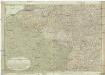
Kriegstheater oder Graenzkarte zwischen Deutschland und Frankreich
1 : 660000 Alsasko (Francie) Müller, Franz Artaria