Maps of Belgium

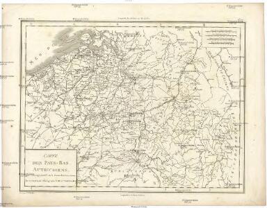
Carte des Pays-Bas Autrichiens
1 : 800000 Belgie Mentelle, Edme Tardieu, Pierre François
Nova totius Belgii regii tabula
1 : 762000 Belgie Wit, Frederick de Frederick de Wit
[104][107] Belgii Regii accuratissima tabula pluribus locis, uit: Atlas sive Descriptio terrarum orbis
Annotatie: Gedigitaliseerde versie. Amsterdam. Heiloo : Picturae (vervaardiger), 2015. tiff-bestand. Gedigitaliseerd: 07-01-2015; Origineel: Universiteitsbibliotheek Vrije Universiteit (XL.05127.-) ; Netherlands; Titelpagina ontbreekt Wit, Frederik de Amsterdam : Frederick de Wit
BELGII REGII accuratissima Tabula
1 : 810000 Belgie Visscher, Nicolaus Nicolao Visscher
La partie Meridionale des Pays Bas, Connue sous le nom de Flandre
1 : 840000 Mollova mapová sbírka Nolin, Jean-Baptiste Nolin, Jean Baptiste
Belgii regii tabula
1 : 822000 Belgie Visscher, Nicolaes Jansz. per Nicolaum Visscher
Western Front. Front line on March 20th, Aug.16th, Sept. 18th 1918.
1 : 600000 First World War map of the Western Front. Front line on March 20th, Aug.16th, Sept. 18th 1918. Shows limits of German advance in 1918. War Office
Province de Cologne, dans la Gaule Belgicque de laquelle
1 : 875000 Mollova mapová sbírka Sanson, Nicolas Mariette, Pierre
The Western Front. June 1918.
1 : 600000 First World War map of the Western Front. June 1918. Front Line June 12th, June 5th and March 20th. War Office
Belgii Regii accuratissima Tabula. [Karte], in: Novus atlas absolutissimus, Bd. 3, S. 25.
1 Karte aus Atlas Janssonius Offizin
Kriegs Atlas 36 Karten von den Schauplätzen des Weltkrieges 1914/1915


Provinciae Belgii regii
1 : 760000 Belgie Danckerts, Justus Iusto Danckerts
PROVINCIAE BELGII REGII
1 : 760000 Belgie Danckerts, Justus Iusto Danckerts
Belgii Pars Meridionalis
1 : 820000 Mollova mapová sbírka Visscher, Nicolaes Schenk, Pieter Schenk, Peter II
Belgium Regium Accuratissime Divisum. &c: Ad Usum Serenissimi Burgundiae Ducis. Authore G. de l'Isle, Geographe
1 : 710000 Mollova mapová sbírka Delisle, Guillaume Luchtenburg, Johannes van Covens, Johannes I
Carte de la république de France, no. 2
1 Blatt : 41 x 58 cm s.n.
Arena martis in Belgio, qua provinciae X. catholicae inferioris Germaniae
1 : 850000 Belgie Homann, Johann Baptist J. B. Homann

Provinciae Belgii regii distinctae eo, quo sunt hodie divisae modo inter regem Galliae, Hispaniae et ordines provinciarum faederatarum tabula novissima et accuratissima
1 : 740000 1 Karte : Kupferdruck ; 49 x 56 cm Danckerts, Justus [Danckerts]
Einsatz der 1./Pz. Rgt. 2 im Westen vom 10. 5. - 6. 9. 1940
Francie Veit Carl Kaestner
Belgique. Carte oro-hydrographique 1:500 000 = België oro-hydrografische kaart 1:500 000
1 : 500000 Ghellinck, A . de Turnhout : Brepols
Netherlands.
1 : 1670000 Seaman, James V.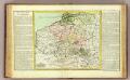
Pay-Bas Autrichiens.
1 : 1020000 Clouet, J. B. L. (Jean-Baptiste Louis), b. 1730
(Les Pays-Bas autrichiens & francois)
1 : 5200000 Bruyset, Jean-Marie; Schneider, J. H.
Germaniae inferioris sive Belgii pars meridionalis
1 : 853800 Belgie Lotter, Tobias Conrad M. Tob Conr. Lotter
Germaniae inferioris sive Belgii pars meridionalis
1 : 853800 Belgie Lotter, Tobias Conrad M. Tob Conr. Lotter
Des Burgundischen Creisses Südlicher theil oder Oesterreichissche Niederlande
1 : 2250000 Mollova mapová sbírka Weigel, Christoph Weigel, Christoph I. - dědici