Maps of Belgium

Germaniae inferioris sive Belgii pars meridionalis
1 : 853800 Belgie Lotter, Tobias Conrad M. Tob Conr. Lotter
Germaniae inferioris sive Belgii pars meridionalis
1 : 853800 Belgie Lotter, Tobias Conrad M. Tob Conr. Lotter

Carte historique de la Belgique au moyen age / par Louis Delgeur
1 : 1135400 Delgeur, Louis [Bruxelles : Vandermaelen]
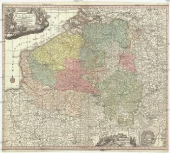
[104][107] Belgii Regii accuratissima tabula pluribus locis, uit: Atlas sive Descriptio terrarum orbis
Annotatie: Gedigitaliseerde versie. Amsterdam. Heiloo : Picturae (vervaardiger), 2015. tiff-bestand. Gedigitaliseerd: 07-01-2015; Origineel: Universiteitsbibliotheek Vrije Universiteit (XL.05127.-) ; Netherlands; Titelpagina ontbreekt Wit, Frederik de Amsterdam : Frederick de Wit
Arena martis in Belgio, qua provinciae X. catholicae inferioris Germaniae
1 : 850000 Belgie Homann, Johann Baptist J. B. Homann

Belgii Regii accuratissima Tabula. [Karte], in: Novus atlas absolutissimus, Bd. 3, S. 25.
1 Karte aus Atlas Janssonius Offizin
Arena Martis in Belgio
1 : 830000 Mollova mapová sbírka Homann, Johann Baptist
Kriegsschauplatz der Niederlande eines Theils von Holland und am Rhein
Nizozemsko Lehnhardt
Belgii regii tabula
1 : 822000 Belgie Visscher, Nicolaes Jansz. per Nicolaum Visscher
BELGII REGII accuratissima Tabula
1 : 810000 Belgie Visscher, Nicolaus Nicolao Visscher
Les provinces des pays-bas Catholiques, ou a most exact map of Flanders or Austrian Netherlands &c.
from The world described, or, A new and correct sett of maps : shewing the kingdoms and states in all the known parts of the earth, with the principal cities, and most considerable towns in the world ... / ... by Herman Moll, geographer ...
Des Burgundischen Creisses Südlicher theil oder Oesterreichissche Niederlande
1 : 2250000 Mollova mapová sbírka Weigel, Christoph Weigel, Christoph I. - dědici
Belgivm Regivm accuratissime descriptum
1 : 1200000 Mollova mapová sbírka Weigel, Christoph Kauffer, Michael Weigel, Christoph I.
Circvlvs Bvrgvndicvs
1 : 732700 Belgie Mayer, Tobias Cassini de Thury Homannianis heredib.
Belgivm catholicvm seu Decem provinciae Germaniae inferioris
1 : 732700 Belgie Mayer, Tobias Cassini de Thury Homannianis heredib.

Belgium Catholicum seu Decem Provinciae Germaniae Inferioris...

Provinciae Belgii regii
1 : 760000 Belgie Danckerts, Justus Iusto Danckerts
PROVINCIAE BELGII REGII
1 : 760000 Belgie Danckerts, Justus Iusto Danckerts
Western Front. Front line on March 20th, Aug.16th, Sept. 18th 1918.
1 : 600000 First World War map of the Western Front. Front line on March 20th, Aug.16th, Sept. 18th 1918. Shows limits of German advance in 1918. War Office
The Western Front. June 1918.
1 : 600000 First World War map of the Western Front. June 1918. Front Line June 12th, June 5th and March 20th. War Office
Belgium Regium Accuratissime Divisum. &c: Ad Usum Serenissimi Burgundiae Ducis. Authore G. de l'Isle, Geographe
1 : 710000 Mollova mapová sbírka Delisle, Guillaume Luchtenburg, Johannes van Covens, Johannes I
Die Niederlande und Belgien
1 : 830000 Belgie Kiepert, Heinrich Eulenstein, F. Geographisches Institut
Pays Bas Catholoques.
1 : 700000 L'Isle, Guillaume de, 1675-1726
Pays Bas Catholoques.
1 : 700000 L'Isle, Guillaume de, 1675-1726
Novissima et accuratissima XVII Provinciarum Germaniae Inferioris Delineatio. [Karte], in: Novus atlas absolutissimus, Bd. 3, S. 22.
1 Karte aus Atlas Janssonius Offizin