Maps of Netherlands
Novissima et accuratissima XVII provinciarum Germaniae Inferioris delineatio / A. Deur sculpsit
1 : 900000 Annotatie: Oorspr. verschenen in: Atlas contractus ... - Amstelaedami : ex officina Nicolai Visscher, [1656-1677]; Origineel is Blad 34 in atlas factice; Annotatie geografische gegevens: West boven Deur, Abraham [Amsterdam : ex officina Nicolai Visscher]
[89][89] Novissima et accuratissima XVII Provinciarum Germaniae Inferioris tabula, uit: Atlas sive Descriptio terrarum orbis
Annotatie: Gedigitaliseerde versie. Amsterdam. Heiloo : Picturae (vervaardiger), 2015. tiff-bestand. Gedigitaliseerd: 07-01-2015; Origineel: Universiteitsbibliotheek Vrije Universiteit (XL.05127.-) ; Netherlands; Titelpagina ontbreekt Wit, Frederik de Amsterdam : Frederick de Wit
Novissima et accuratissima XVII Provinciarum Germaniae Inferioris Delineatio. [Karte], in: Novus atlas absolutissimus, Bd. 3, S. 22.
1 Karte aus Atlas Janssonius Offizin
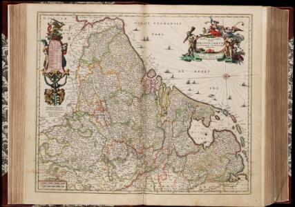
Novissima et accuratissima XVII provinciarum Germaniae Inferioris delineatio
1 : 910000 A. Deur sculpsit. [Amsterdam] : ex officina Nicolai Visscher

Novissima et accuratissima XVII provinciarum Germaniae inferioris tabula
1 : 897000 Belgie Wit, Frederick de Munter, Johann ex officina Reineri & Josuae Ottens
Die Niederlande und Belgien
1 : 830000 Belgie Kiepert, Heinrich Eulenstein, F. Geographisches Institut
Novissima, et accuratissima leonis Belgici, seu septemdecim regionum descriptio
1 : 1200000 Antverpy (Belgie) Visscher, Claes Jansz. by Claes Iansz. Visscher
Niederlande u. Belgien.
1 : 1050000 Stein, Christ. Gottfr. Dan.
Novissima et accuratissima XVII provinciarum Germaniae inferioris delineatio
1 : 897000 Belgie Visscher, Nicolaes Jansz. ex officina Nicolai Visscher
Germaniae Inferioris XVII provinciarum accuratissima tabula / nuperrime edita per Nicolaum Visscher
1 : 950000 Annotatie: Met privilege; Met opdracht aan Theodorus Munter; Annotatie geografische gegevens: West boven Visscher, Nicolaes (1649-1702) [Amsterdam : N. Visscher]
Nieuwe en nauwkeurige kaart der XVII Provincien van Nederland
1 : 1800000 Amsterdam : by Isaak Tirion
Novissima et accuratissima XVII provinciarum Germaniae inferioris tabula
1 : 800000 1 Karte : Kupferdruck ; 47 x 54 cm Danckerts, Justus [Danckerts]
Niederlande und Belgien
Adolf Stieler's Handatlas über alle Theile der Erde und über das Weltgebäude Stieler, Adolf Justus Perthes
Das Königreich Niederlande, das Königreich Belgien, und das Grossherzogthum Luxemburg
1 : 925000 Belgie Schmitfeldt, Georg Mollo, Tranquillo Tranquillo Mollo
Belgium & Holland.
1 : 1000000 John Bartholomew and Son
[Historisch-geographischer Atlas zu den allgemeinen Geschichtswerken von C. v. Rotteck, Pölitz u. Becker] : Die Niederlande zur Uebersicht der Hauptbegebenheiten
von Julius Loewenberg Lithographie von B. Herder zu Freiburg im Breisgau [Freiburg im Breisgau] : [Herder]
Nova Totius Belgii Sive Germaniae Inferioris accuratissima Delineatio. [Karte], in: Novus atlas absolutissimus, Bd. 3, S. 11.
1 Karte aus Atlas Janssonius Offizin
NOVUS XVII | INFERIORIS GERMANIÆ | PROVINCIARUM TYPUS
de integro multis in locis emendatus à Guliel. Ianßonio. Josua | vanden Ende sculp. Ghedruckt | t'Amsterdam, | bij Willem Ianszoon op 't Water | inde vergulde Zonnewyser
Bez titulu: soubor map pag. 97

Belgii sive Germaniae Inferioris accuratissima tabula. [Karte], in: Gerardi Mercatoris et I. Hondii Newer Atlas, oder, Grosses Weltbuch, Bd. 1, S. 368.
1 Karte aus Atlas Mercator, Gerhard und Hondius, Jodocus Jansson, Jan
Germaniae Inferioris XVII Provinciarum accuratissima tabula
1 : 940000 nuperrime edita per Nicolaum Visscher. [Amsterdam] : nunc apud Petrum Schenk Jun.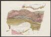
Novus XVII Inferioris Germaniae Provinciarum Typus [Karte], in: Le théâtre du monde, ou, Nouvel atlas contenant les chartes et descriptions de tous les païs de la terre, Bd. 1, S. 329.
1 Karte aus Atlas Blaeu, Willem Janszoon und Blaeu, Joan Blaeu, Willem Janszoon
Novus XVII Inferioris Germaniae Procinviarum Typus [Karte], in: Theatrum orbis terrarum, sive, Atlas novus, Bd. 1, S. 323.
1 Karte aus Atlas Blaeu, Joan Blaeu, Willem Janszoon
Nieuwe kaart van de XVII Nederlandsche Provincien : waar in aangewezen worden de landen door den Koning van Vrankryk geconquesteerd als mede die van het Huis van Oostenryk, van den Koning van Pruisen en den Staat der Vereenigde Nederlanden, alles volgens het laatste tractaat van Barriere / uitgege[ve]n door Reinier en Josua Ottens te Amsterdam
1 : 875000 Annotatie geografische gegevens: Bevat schaalstokken in Duytsche mylen en France mylen Reinier Ottens 1698-1750; Josua Ottens 1704-1765 te Amsterdam : Reinier en Josua Ottens
NOVUS XVII | INFERIORIS GERMANIÆ | PROVINCIARUM TYPUS
de integro multis in locis emendatus à Guliel. Ianßonio. Josua | vanden Ende sculp. Ghedruckt | t'Amsterdam, | bij Willem Ianszoon op 't Water | inde vergulde Zonnewyser
Novus XVII Inferioris Germaniae Provinciarum Typus [...] [Karte], in: Novus Atlas, das ist, Weltbeschreibung, Bd. 1, S. 298.
1 Karte aus Atlas Blaeu, Joan Blaeu, Willem Janszoon
Leo Belgicus / Johan van Doetechum fecit
1 : 350000 Annotatie: Facs. van de uitg.: [Amsterdam] : C.J. Visscher excudit, 1650. - Het betreft de 3e staat van de kaart van J. van Doetechum uit 1598, bijgewerkt door C.J. Visscher; Uitg. t.g.v. de tentoonstelling "De wereld op papier", in het Amsterdams Historisch Museum, april 1967 Joannes van Doetecum de Oudere -1605; Visscher, Claes Jansz. [S.l. : s.n.]
Niederlande und Belgien
Neuer Handatlas über alle Theile der Erde Kiepert, Heinrich Verlag von Dietrich Reimer