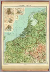
Maps of Netherlands

Belgium & Holland.
1 : 1000000 John Bartholomew and Son
Novissima et accuratissima XVII Provinciarum Germaniae Inferioris Delineatio. [Karte], in: Novus atlas absolutissimus, Bd. 3, S. 22.
1 Karte aus Atlas Janssonius Offizin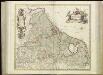
[89][89] Novissima et accuratissima XVII Provinciarum Germaniae Inferioris tabula, uit: Atlas sive Descriptio terrarum orbis
Annotatie: Gedigitaliseerde versie. Amsterdam. Heiloo : Picturae (vervaardiger), 2015. tiff-bestand. Gedigitaliseerd: 07-01-2015; Origineel: Universiteitsbibliotheek Vrije Universiteit (XL.05127.-) ; Netherlands; Titelpagina ontbreekt Wit, Frederik de Amsterdam : Frederick de Wit
Novissima, et accuratissima leonis Belgici, seu septemdecim regionum descriptio
1 : 1200000 Antverpy (Belgie) Visscher, Claes Jansz. by Claes Iansz. Visscher

De groote Nederlandse stedenwyzer, vertoonende met een opslag des oogs, de afgelegentheden tussen 108 steden der XVII. provintien, of Beantwoording op 5786 vragen, hoe veel uuren gaans de eene plaats van den ander is gelegen = La grande echelle des Pais-Bas, qui montre du premier coup d’oeil, la distence de 108 villes, des XVII. provinces, ou Reponce sur 5786. demandes, pour savoir de quelle distence une ville est eloignée de l’autre
te samen gesteld en int ligt gegeeven door Jan de Lat kaart en boekverkoper tot Deventer. Deventer : Jan de Lat
Novus XVII Inferioris Germaniae Procinviarum Typus [Karte], in: Theatrum orbis terrarum, sive, Atlas novus, Bd. 1, S. 323.
1 Karte aus Atlas Blaeu, Joan Blaeu, Willem Janszoon
Die Niederlande und Belgien
1 : 830000 Belgie Kiepert, Heinrich Eulenstein, F. Geographisches Institut
NOVUS XVII | INFERIORIS GERMANIÆ | PROVINCIARUM TYPUS
de integro multis in locis emendatus à Guliel. Ianßonio. Josua | vanden Ende sculp. Ghedruckt | t'Amsterdam, | bij Willem Ianszoon op 't Water | inde vergulde Zonnewyser
NOVUS XVII | INFERIORIS GERMANIÆ | PROVINCIARUM TYPUS
de integro multis in locis emendatus à Guliel. Ianßonio. Josua | vanden Ende sculp. Ghedruckt | t'Amsterdam, | bij Willem Ianszoon op 't Water | inde vergulde Zonnewyser
Bez titulu: soubor map pag. 97
Novissima et accuratissima XVII provinciarum Germaniae inferioris tabula
1 : 800000 1 Karte : Kupferdruck ; 47 x 54 cm Danckerts, Justus [Danckerts]
Novus XVII Inferioris Germaniae Provinciarum Typus [...] [Karte], in: Novus Atlas, das ist, Weltbeschreibung, Bd. 1, S. 298.
1 Karte aus Atlas Blaeu, Joan Blaeu, Willem Janszoon
Novissima et accuratissima XVII provinciarum Germaniae Inferioris delineatio
1 : 910000 A. Deur sculpsit. [Amsterdam] : ex officina Nicolai Visscher
Novus XVII Inferioris Germaniae Provinciarum Typus [Karte], in: Le théâtre du monde, ou, Nouvel atlas contenant les chartes et descriptions de tous les païs de la terre, Bd. 1, S. 329.
1 Karte aus Atlas Blaeu, Willem Janszoon und Blaeu, Joan Blaeu, Willem Janszoon
Nieuwe en nauwkeurige kaart der XVII Provincien van Nederland
1 : 1800000 Amsterdam : by Isaak Tirion
Novissima et accuratissima XVII provinciarum Germaniae inferioris tabula
1 : 897000 Belgie Wit, Frederick de Munter, Johann ex officina Reineri & Josuae Ottens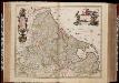
Novissima et accuratissima XVII provinciarum Germaniae Inferioris delineatio / A. Deur sculpsit
1 : 900000 Annotatie: Oorspr. verschenen in: Atlas contractus ... - Amstelaedami : ex officina Nicolai Visscher, [1656-1677]; Origineel is Blad 34 in atlas factice; Annotatie geografische gegevens: West boven Deur, Abraham [Amsterdam : ex officina Nicolai Visscher]
Novissima et accuratissima XVII provinciarum Germaniae inferioris delineatio
1 : 897000 Belgie Visscher, Nicolaes Jansz. ex officina Nicolai Visscher
Belgii sive Germaniae Inferioris accuratissima tabula. [Karte], in: Gerardi Mercatoris et I. Hondii Newer Atlas, oder, Grosses Weltbuch, Bd. 1, S. 368.
1 Karte aus Atlas Mercator, Gerhard und Hondius, Jodocus Jansson, Jan
Nova Totius Belgii Sive Germaniae Inferioris accuratissima Delineatio. [Karte], in: Novus atlas absolutissimus, Bd. 3, S. 11.
1 Karte aus Atlas Janssonius Offizin
Germaniae Inferioris XVII Provinciarum accuratissima tabula
1 : 940000 nuperrime edita per Nicolaum Visscher. [Amsterdam] : nunc apud Petrum Schenk Jun.
Les Pays Bas.
1 : 2150000 Lattre, Jean
Mare Germanicum ab Amelandia ad promontoria Caleti et Doveræ
1 Karte : Kupferdruck ; 47 x 57 cm Renard by L. Renard
Belgique, Hollande.
1 : 1000000 Lapie, M. (Pierre), 1779-1850
Nieuwe kaart van de XVII Nederlandsche Provincien : waar in aangewezen worden de landen door den Koning van Vrankryk geconquesteerd als mede die van het Huis van Oostenryk, van den Koning van Pruisen en den Staat der Vereenigde Nederlanden, alles volgens het laatste tractaat van Barriere / uitgege[ve]n door Reinier en Josua Ottens te Amsterdam
1 : 875000 Annotatie geografische gegevens: Bevat schaalstokken in Duytsche mylen en France mylen Reinier Ottens 1698-1750; Josua Ottens 1704-1765 te Amsterdam : Reinier en Josua Ottens
Germaniae Inferioris XVII provinciarum accuratissima tabula / nuperrime edita per Nicolaum Visscher
1 : 950000 Annotatie: Met privilege; Met opdracht aan Theodorus Munter; Annotatie geografische gegevens: West boven Visscher, Nicolaes (1649-1702) [Amsterdam : N. Visscher]
Niederlande und Belgien
Adolf Stieler's Handatlas über alle Theile der Erde und über das Weltgebäude Stieler, Adolf Justus Perthes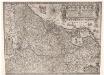
Inferioris Germaniae provinciarum nova descriptio / [Willem Jansz. Blaeu]
1 : 900000 Annotatie: Onder de titel een nadere omschrijving in het Latijn en Nederlands; Aan het oorspronkelijke kaartbeeld zijn het Bourtangerveen en Fort Bourtange toegevoegd; Lit.: Monumenta cartografica Neerlandica, IV, p. 31-32, 146-153, facs. 5; Oorspr. uitg.: 1604 Blaeu, Willem Jansz. Amstelodami : ex officina Guilielmi Johannis