Maps of Netherlands

Nova Totius Belgii Sive Germaniae Inferioris accuratissima Delineatio. [Karte], in: Novus atlas absolutissimus, Bd. 3, S. 11.
1 Karte aus Atlas Janssonius Offizin
Belgii sive Germaniae Inferioris accuratissima tabula. [Karte], in: Gerardi Mercatoris et I. Hondii Newer Atlas, oder, Grosses Weltbuch, Bd. 1, S. 368.
1 Karte aus Atlas Mercator, Gerhard und Hondius, Jodocus Jansson, Jan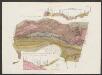
Novus XVII Inferioris Germaniae Provinciarum Typus [Karte], in: Le théâtre du monde, ou, Nouvel atlas contenant les chartes et descriptions de tous les païs de la terre, Bd. 1, S. 329.
1 Karte aus Atlas Blaeu, Willem Janszoon und Blaeu, Joan Blaeu, Willem Janszoon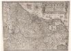
Inferioris Germaniae provinciarum nova descriptio / [Willem Jansz. Blaeu]
1 : 900000 Annotatie: Onder de titel een nadere omschrijving in het Latijn en Nederlands; Aan het oorspronkelijke kaartbeeld zijn het Bourtangerveen en Fort Bourtange toegevoegd; Lit.: Monumenta cartografica Neerlandica, IV, p. 31-32, 146-153, facs. 5; Oorspr. uitg.: 1604 Blaeu, Willem Jansz. Amstelodami : ex officina Guilielmi Johannis
Novus XVII Inferioris Germaniae Provinciarum Typus [...] [Karte], in: Novus Atlas, das ist, Weltbeschreibung, Bd. 1, S. 298.
1 Karte aus Atlas Blaeu, Joan Blaeu, Willem Janszoon
NOVUS XVII | INFERIORIS GERMANIÆ | PROVINCIARUM TYPUS
de integro multis in locis emendatus à Guliel. Ianßonio. Josua | vanden Ende sculp. Ghedruckt | t'Amsterdam, | bij Willem Ianszoon op 't Water | inde vergulde Zonnewyser
NOVUS XVII | INFERIORIS GERMANIÆ | PROVINCIARUM TYPUS
de integro multis in locis emendatus à Guliel. Ianßonio. Josua | vanden Ende sculp. Ghedruckt | t'Amsterdam, | bij Willem Ianszoon op 't Water | inde vergulde Zonnewyser
Novus XVII Inferioris Germaniae Procinviarum Typus [Karte], in: Theatrum orbis terrarum, sive, Atlas novus, Bd. 1, S. 323.
1 Karte aus Atlas Blaeu, Joan Blaeu, Willem Janszoon
[Königreich der Niederlande]
Neuester Schul-Atlas Walch, Johann im Verlag bei Joh. Walch
Niederland u. Belgien
1 : 2220000 Belgie Stein, Carl
Leo Belgicus / Johan van Doetechum fecit
1 : 350000 Annotatie: Facs. van de uitg.: [Amsterdam] : C.J. Visscher excudit, 1650. - Het betreft de 3e staat van de kaart van J. van Doetechum uit 1598, bijgewerkt door C.J. Visscher; Uitg. t.g.v. de tentoonstelling "De wereld op papier", in het Amsterdams Historisch Museum, april 1967 Joannes van Doetecum de Oudere -1605; Visscher, Claes Jansz. [S.l. : s.n.]
Niederlande, Luxemburg.
1 : 1900000 Reichard, C. G.
Holland or the Seven United Provinces, and the Netherlands.
from Carey's general atlas, improved and enlarged : being a collection of maps of the world and quarters, their principal empires, kingdoms, &c.
Die Niederlande und Belgien
1 : 830000 Belgie Kiepert, Heinrich Eulenstein, F. Geographisches Institut
Niederlande und Belgien
Adolf Stieler's Handatlas über alle Theile der Erde und über das Weltgebäude Stieler, Adolf Justus Perthes
Das Königreich Niederlande, das Königreich Belgien, und das Grossherzogthum Luxemburg
1 : 925000 Belgie Schmitfeldt, Georg Mollo, Tranquillo Tranquillo Mollo
Les Pays Bas.
1 : 2150000 Lattre, Jean
Mare Germanicum ab Amelandia ad promontoria Caleti et Doveræ
1 Karte : Kupferdruck ; 47 x 57 cm Renard by L. Renard
Novissima et accuratissima XVII Provinciarum Germaniae Inferioris Delineatio. [Karte], in: Novus atlas absolutissimus, Bd. 3, S. 22.
1 Karte aus Atlas Janssonius Offizin
Descriptio Germaniae Inferioris. [Karte], in: Theatrum orbis terrarum, S. 42.
1 Karte aus Atlas Ortelius, Abraham
[Recto], uit: Descriptio Germaniae Inferioris
1 : 1000000 Annotatie: Waarschijnlijk gegraveerd door F. Hogenberg; Uit: Theatrum Orbis Terrarm. - Antwerpen, 1570 Hogenberg, Franz [Antwerpen : Abraham Ortelius]

Naauwkeurige kaart van het oude Nederland en eenige aangrenzende gewesten.
1 : 2000000 Isaak Tirion. Te Amsterdam : by Isaak Tirion
Europe Centrale (Partie Occidentale).
1 : 1750000 Jouvet et Cie.
Descriptio Germaniae Inferioris. [Karte], in: Theatrum orbis terrarum, S. 162.
1 Karte aus Atlas Ortelius, Abraham Vrients, Jan Baptista
Belgii Veteris Typus. [Karte], in: Theatrum orbis terrarum, S. 470.
1 Karte aus Atlas Ortelius, Abraham Vrients, Jan Baptista
Holland and Belgium.
1 : 2080000 Tanner, Henry S.
Nova mappa geographica Belgii universi seu Inferioris Germaniae quam XVII Provinciae, Austriaco, Gallico et Batavo sceptro parentes constituunt
1 : 1000000 cura et sum[p]tibus Joh: Michaelem Probst Aug. Vind. Aug. Vind : J.M. Probst
D.O.M. Carte Generale Des Dixsept Provinces des Pays-Bas avec les Frontieres de France, d'Allemagne et Partie de l'Angleterre Nouvellement dreßée sur plusieur Momoires tirés sur les Lieux pendant les Guerres
1 : 750000 Mollova mapová sbírka Sengre, Henri Misson, François Maximilien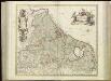
![Nova Totius Belgii Sive Germaniae Inferioris accuratissima Delineatio. [Karte], in: Novus atlas absolutissimus, Bd. 3, S. 11.](https://images-2.georeferencer.com/images/iiif/644558703681/full/,300/0/native.jpg)

