Maps of Netherlands

[Königreich der Niederlande]
Neuester Schul-Atlas Walch, Johann im Verlag bei Joh. Walch
Europe Centrale (Partie Occidentale).
1 : 1750000 Jouvet et Cie.
D.O.M. Carte Generale Des Dixsept Provinces des Pays-Bas avec les Frontieres de France, d'Allemagne et Partie de l'Angleterre Nouvellement dreßée sur plusieur Momoires tirés sur les Lieux pendant les Guerres
1 : 750000 Mollova mapová sbírka Sengre, Henri Misson, François Maximilien
Descriptio Germaniae Inferioris. [Karte], in: Theatrum orbis terrarum, S. 162.
1 Karte aus Atlas Ortelius, Abraham Vrients, Jan Baptista
[Recto], uit: Descriptio Germaniae Inferioris
1 : 1000000 Annotatie: Waarschijnlijk gegraveerd door F. Hogenberg; Uit: Theatrum Orbis Terrarm. - Antwerpen, 1570 Hogenberg, Franz [Antwerpen : Abraham Ortelius]
Descriptio Germaniae Inferioris. [Karte], in: Theatrum orbis terrarum, S. 42.
1 Karte aus Atlas Ortelius, Abraham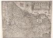
Inferioris Germaniae provinciarum nova descriptio / [Willem Jansz. Blaeu]
1 : 900000 Annotatie: Onder de titel een nadere omschrijving in het Latijn en Nederlands; Aan het oorspronkelijke kaartbeeld zijn het Bourtangerveen en Fort Bourtange toegevoegd; Lit.: Monumenta cartografica Neerlandica, IV, p. 31-32, 146-153, facs. 5; Oorspr. uitg.: 1604 Blaeu, Willem Jansz. Amstelodami : ex officina Guilielmi Johannis
Holland or the Seven United Provinces, and the Netherlands.
from Carey's general atlas, improved and enlarged : being a collection of maps of the world and quarters, their principal empires, kingdoms, &c.
Bojište [sic] 1870
Belgie Bedřich Sandtner
Nouvelle carte geographique des postes des Pais Bas, de la Westphalie, & des provinces limitrophes
1 : 1
Leo Belgicus / Johan van Doetechum fecit
1 : 350000 Annotatie: Facs. van de uitg.: [Amsterdam] : C.J. Visscher excudit, 1650. - Het betreft de 3e staat van de kaart van J. van Doetechum uit 1598, bijgewerkt door C.J. Visscher; Uitg. t.g.v. de tentoonstelling "De wereld op papier", in het Amsterdams Historisch Museum, april 1967 Joannes van Doetecum de Oudere -1605; Visscher, Claes Jansz. [S.l. : s.n.]
Neue und richtige Landtafel der XVII Niderländische Provincien : abbildende alle befestigte, bemauerte, offene Stedte und Schantzen, etc.
1 : 1260000 Annotatie geografische gegevens: Noordwest boven Nürnberg : Jacob Sandrart
Bez titulu: Severozápadní Evropa

Nova Totius Belgii Sive Germaniae Inferioris accuratissima Delineatio. [Karte], in: Novus atlas absolutissimus, Bd. 3, S. 11.
1 Karte aus Atlas Janssonius Offizin
Belgii sive Germaniae Inferioris accuratissima tabula. [Karte], in: Gerardi Mercatoris et I. Hondii Newer Atlas, oder, Grosses Weltbuch, Bd. 1, S. 368.
1 Karte aus Atlas Mercator, Gerhard und Hondius, Jodocus Jansson, Jan
Naauwkeurige kaart van het oude Nederland en eenige aangrenzende gewesten.
1 : 2000000 Isaak Tirion. Te Amsterdam : by Isaak Tirion
Nouvelle Carte du Royaume des Pays - Bas et Pays Limithropes...

Atlas für Handel und Industrie: Für Kaufleute, Fabrikante u. Gewerbetreibende, Handlungs- u. Gewerbe-Schulen
Novus XVII Inferioris Germaniae Provinciarum Typus [Karte], in: Le théâtre du monde, ou, Nouvel atlas contenant les chartes et descriptions de tous les païs de la terre, Bd. 1, S. 329.
1 Karte aus Atlas Blaeu, Willem Janszoon und Blaeu, Joan Blaeu, Willem Janszoon
Novus XVII Inferioris Germaniae Provinciarum Typus [...] [Karte], in: Novus Atlas, das ist, Weltbeschreibung, Bd. 1, S. 298.
1 Karte aus Atlas Blaeu, Joan Blaeu, Willem Janszoon
Carte du Royaume des Pays-Bas, comprenant les routes de poste et relais depuis Paris jusqu'aux frontières septentrionales de la Hollande, avec un Itinéraire des communications de Strasbourg à Amsterdam et Hambourg
1 : 1280000 [par] Hocquart. Paris : Audin
Holland and Belgium.
1 : 2080000 Tanner, Henry S.
Belgii Veteris Typus. [Karte], in: Theatrum orbis terrarum, S. 470.
1 Karte aus Atlas Ortelius, Abraham Vrients, Jan Baptista
Unsere Westgrenze
1 : 1000000 Evropa západní Velhagen & Klasing
Tabula generalis totius Belgii
1 : 1000000 Belgie Homann, Johann Baptist á Iohanne Baptista Homanno
TABULA GENERALIS TOTIUS BELGII qua PROVINCIAE XVII. INFER. GERMANIAE olim sub S.R.I. CIRCULO BURGUNDIAE
1 : 1100000 Belgie Homann, Johann Baptist â Iohanne Baptista Homanno
Tabula generalis totius Belgii
1 : 1000000 Belgie Homann, Johann Baptist á Iohanne Baptista Homanno
Tabula generalis totius Belgii
1 : 1000000 Belgie Homann, Johann Baptist â Iohanne Baptista Homanno
Niederland u. Belgien
1 : 2220000 Belgie Stein, Carl
![[Königreich der Niederlande]](https://images-2.georeferencer.com/images/iiif/316383577478/full/,300/0/native.jpg)

