Maps of Niedersachsen

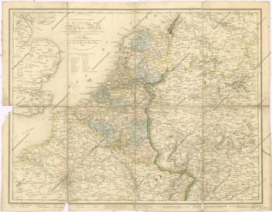
Nouvelle Carte du Royaume des Pays - Bas et Pays Limithropes...

Tabula generalis totius Belgii
1 : 1000000 Belgie Homann, Johann Baptist á Iohanne Baptista Homanno
TABULA GENERALIS TOTIUS BELGII qua PROVINCIAE XVII. INFER. GERMANIAE olim sub S.R.I. CIRCULO BURGUNDIAE
1 : 1100000 Belgie Homann, Johann Baptist â Iohanne Baptista Homanno
Tabula generalis totius Belgii
1 : 1000000 Belgie Homann, Johann Baptist á Iohanne Baptista Homanno
Tabula generalis totius Belgii
1 : 1000000 Belgie Homann, Johann Baptist â Iohanne Baptista Homanno
Atlas für Handel und Industrie: Für Kaufleute, Fabrikante u. Gewerbetreibende, Handlungs- u. Gewerbe-Schulen
Soubor map
A new map of the Netherlands or Low Countries, shewing their principal divisions, cities, towns, rivers &c.
from A new sett of maps both of antient and present geography : wherein not only the latitude and longitude of many places are corrected according to the latest observations, but also the most remarkable differences of antient and present geography may be quickly discern'd by a bare inspection or comparing of correspondent maps, which seems to be the most natural and easy method to lead young students (for whose use the work is principally intended) unto a competent knowledge of the geographical science : together with a geographical treatise particularly adapted to the use and design of these maps / by Edward Wells, M.A. and student of Christ-Church, Oxon.
Birds eye view of the seat of War in Europe
1 : 1
Naauwkeurige kaart van het oude Nederland en eenige aangrenzende gewesten.
1 : 2000000 Isaak Tirion. Te Amsterdam : by Isaak Tirion
Unsere Westgrenze
1 : 1000000 Evropa západní Velhagen & Klasing
Letecká navigační mapa

Royaume des Pays-Bas. Europe 13.
1 : 1641836 Vandermaelen, Philippe, 1795-1869

Bez titulu: Severozápadní Evropa

D.O.M. Carte Generale Des Dixsept Provinces des Pays-Bas avec les Frontieres de France, d'Allemagne et Partie de l'Angleterre Nouvellement dreßée sur plusieur Momoires tirés sur les Lieux pendant les Guerres
1 : 750000 Mollova mapová sbírka Sengre, Henri Misson, François Maximilien
Descriptio Germaniae Inferioris. [Karte], in: Theatrum orbis terrarum, S. 42.
1 Karte aus Atlas Ortelius, Abraham
[Recto], uit: Descriptio Germaniae Inferioris
1 : 1000000 Annotatie: Waarschijnlijk gegraveerd door F. Hogenberg; Uit: Theatrum Orbis Terrarm. - Antwerpen, 1570 Hogenberg, Franz [Antwerpen : Abraham Ortelius]
[Nordwestliches Deutschland, Kgr. Der Niederlande, Kgr. Belgien]
Hand-Atlas über alle Theile der Erde nach dem neuesten Zustande und über das Weltgebäude Stieler, Adolf bei Justus Perthes
Descriptio Germaniae Inferioris. [Karte], in: Theatrum orbis terrarum, S. 162.
1 Karte aus Atlas Ortelius, Abraham Vrients, Jan Baptista
Belgii Veteris Typus. [Karte], in: Theatrum orbis terrarum, S. 470.
1 Karte aus Atlas Ortelius, Abraham Vrients, Jan Baptista
Germania Parte Occidentale
1 : 2100000 Mollova mapová sbírka Coronelli, Vincenzo Maria
Germania Parte Occidentale
1 : 2100000 Mollova mapová sbírka Coronelli, Vincenzo Maria
Nouvelle carte geographique des postes des Pais Bas, de la Westphalie, & des provinces limitrophes
1 : 1
Belgii Veteris Typus [...] [Karte], in: Gerardi Mercatoris et I. Hondii Newer Atlas, oder, Grosses Weltbuch, Bd. 1, S. 361.
1 Karte aus Atlas Mercator, Gerhard und Hondius, Jodocus Jansson, Jan
Der Deutsch-französische Kriegsschauplatz
1 : 900000 Evropa severozápadní König, Gustav Moriz Perles
Nord-Westliches Deutschland, Niederlande und Belgien
Hand-Atlas über alle Theile der Erde und über das Weltgebäude Stieler, Adolf Justus Perthes
Europe Centrale (Partie Occidentale).
1 : 1750000 Jouvet et Cie.
[Nordwestliches Deutschland, Kgr. der Niederlande, Kgr. Belgien]
Hand-Atlas über alle Theile der Erde nach dem neuesten Zustande und über das Weltgebäude Stieler, Adolf bei Justus Perthes