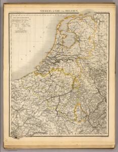
Maps of Netherlands

Niederlande u. Belgien.
1 : 1050000 Stein, Christ. Gottfr. Dan.
Germaniae Inferioris XVII provinciarum accuratissima tabula / nuperrime edita per Nicolaum Visscher
1 : 950000 Annotatie: Met privilege; Met opdracht aan Theodorus Munter; Annotatie geografische gegevens: West boven Visscher, Nicolaes (1649-1702) [Amsterdam : N. Visscher]
Novissima et accuratissima XVII provinciarum Germaniae Inferioris delineatio / A. Deur sculpsit
1 : 900000 Annotatie: Oorspr. verschenen in: Atlas contractus ... - Amstelaedami : ex officina Nicolai Visscher, [1656-1677]; Origineel is Blad 34 in atlas factice; Annotatie geografische gegevens: West boven Deur, Abraham [Amsterdam : ex officina Nicolai Visscher]
Das Königreich Niederlande, das Königreich Belgien, und das Grossherzogthum Luxemburg
1 : 925000 Belgie Schmitfeldt, Georg Mollo, Tranquillo Tranquillo Mollo
Novissima et accuratissima XVII Provinciarum Germaniae Inferioris Delineatio. [Karte], in: Novus atlas absolutissimus, Bd. 3, S. 22.
1 Karte aus Atlas Janssonius Offizin
Die Niederlande und Belgien
1 : 830000 Belgie Kiepert, Heinrich Eulenstein, F. Geographisches Institut
Niederlande und Belgien
Neuer Handatlas über alle Theile der Erde Kiepert, Heinrich Verlag von Dietrich Reimer
[Historisch-geographischer Atlas zu den allgemeinen Geschichtswerken von C. v. Rotteck, Pölitz u. Becker] : Die Niederlande zur Uebersicht der Hauptbegebenheiten
von Julius Loewenberg Lithographie von B. Herder zu Freiburg im Breisgau [Freiburg im Breisgau] : [Herder]

Niederlande und Belgien
Adolf Stieler's Handatlas über alle Theile der Erde und über das Weltgebäude Stieler, Adolf Justus Perthes
Niederlande u. Belgien
[Allgemeiner Atlas über alle Theile der Erde in 29 Blättern] Ziegler, Jakob Melchior Top. Anstalt v. J. Wurster u. Comp.
[89][89] Novissima et accuratissima XVII Provinciarum Germaniae Inferioris tabula, uit: Atlas sive Descriptio terrarum orbis
Annotatie: Gedigitaliseerde versie. Amsterdam. Heiloo : Picturae (vervaardiger), 2015. tiff-bestand. Gedigitaliseerd: 07-01-2015; Origineel: Universiteitsbibliotheek Vrije Universiteit (XL.05127.-) ; Netherlands; Titelpagina ontbreekt Wit, Frederik de Amsterdam : Frederick de Wit
Carte du Royaume des Pays-Bas, comprenant les routes de poste et relais depuis Paris jusqu'aux frontières septentrionales de la Hollande, avec un Itinéraire des communications de Strasbourg à Amsterdam et Hambourg
1 : 1280000 [par] Hocquart. Paris : Audin
Niederland und Belgien
Geographischer Atlas über alle Theile der Erde Ziegler, Jakob Melchior Verlag von Joh. Wurster um Comp.
Niederlande und Belgien
Geographischer Atlas über alle Theile der Erde Ziegler, Jakob Melchior Verlag von Dietrich Reimer
Inferioris Germaniae provinciarum nova descriptio / [Willem Jansz. Blaeu]
1 : 900000 Annotatie: Onder de titel een nadere omschrijving in het Latijn en Nederlands; Aan het oorspronkelijke kaartbeeld zijn het Bourtangerveen en Fort Bourtange toegevoegd; Lit.: Monumenta cartografica Neerlandica, IV, p. 31-32, 146-153, facs. 5; Oorspr. uitg.: 1604 Blaeu, Willem Jansz. Amstelodami : ex officina Guilielmi Johannis
Belgique, Hollande.
1 : 1000000 Lapie, M. (Pierre), 1779-1850
Novissima et accuratissima XVII provinciarum Germaniae Inferioris delineatio
1 : 910000 A. Deur sculpsit. [Amsterdam] : ex officina Nicolai Visscher
Novissima, et accuratissima leonis Belgici, seu septemdecim regionum descriptio
1 : 1200000 Antverpy (Belgie) Visscher, Claes Jansz. by Claes Iansz. Visscher
Leo Belgicus / Johan van Doetechum fecit
1 : 350000 Annotatie: Facs. van de uitg.: [Amsterdam] : C.J. Visscher excudit, 1650. - Het betreft de 3e staat van de kaart van J. van Doetechum uit 1598, bijgewerkt door C.J. Visscher; Uitg. t.g.v. de tentoonstelling "De wereld op papier", in het Amsterdams Historisch Museum, april 1967 Joannes van Doetecum de Oudere -1605; Visscher, Claes Jansz. [S.l. : s.n.]
Holland and Belgium.
1 : 2080000 Tanner, Henry S.
Holland And Belgium.
1 : 1900800 Mitchell, Samuel Augustus
Belgium And Holland.
1 : 1520640 Burr, David H., 1803-1875
Netherlands.
1 : 3350000 Fenner, Rest.
Netherlands, Belgium, Spain, Portugal.
Goodrich, S.G.
Netherlands.
1 : 1480000 Society for the Diffusion of Useful Knowledge (Great Britain)
XVII provinciae Belgii sive Germaniae inferioris priscis temporib. circulo Burgundico S. R. I. annumeratae quarum X. hodie maximam partem Hispaniarum non nullae Galliae regis ditioni subjacent, VII vero sub nomine foederatarum provinciar libertate gaudent
1 : 1050000 Belgie Seutter, Matthäus Mathaei Seutteri
Novissima et accuratissima XVII provinciarum Germaniae inferioris tabula
1 : 897000 Belgie Wit, Frederick de Munter, Johann ex officina Reineri & Josuae Ottens