Maps of Belgium

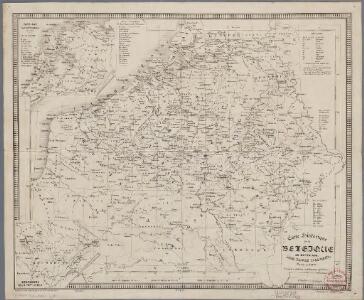
Carte historique de la Belgique au moyen age / par Louis Delgeur
1 : 1135400 Delgeur, Louis [Bruxelles : Vandermaelen]
Kriegsschauplatz der Niederlande eines Theils von Holland und am Rhein
Nizozemsko Lehnhardt

Arena martis in Belgio, qua provinciae X. catholicae inferioris Germaniae
1 : 850000 Belgie Homann, Johann Baptist J. B. Homann
XVII. Provinciae Belgii sive Germaniae Inferioris
1 : 1100000 Mollova mapová sbírka Seutter, Matthäus Seutter, Matthäus
Tabula generalis totius Belgii qua provinciae XVII Infer. Germaniae olim sub S. R. I. circulo Burgundiae comprehensae nunc in Varias Potentias tum liberas utpote Prov. VII Foederatas, tum reliquas Hispaniae, et Galliae coronis subjectas, separata ostenduntur
1 : 1000000 Mollova mapová sbírka Homann, Johann Baptist Homann, Johann Baptista
Belgivm sive Inferior Germania
1 : 1500000 Mollova mapová sbírka Weigel, Christoph Goos, Abraham Weigel, Christoph I.
Map Western Front.
1 : 633600 C.S. Hammond & Company
Flanders or the Spanish Provinces.
from A new systeme of the mathematicks: containing I. Arithmetick, as well natural and decimal, as in species, or the principles of algebra. II. Practical geometry, together with the first six books of Euclid's Elements, as also the eleventh and twelfth, symbo
Belgii XVII. Provintiarum. Universa Tabula Ad Usum Serenissimi Burgundiae Ducis
1 : 1000000 Mollova mapová sbírka Jaillot, Alexis-Hubert Jaillot, Alexis Hubert
Germaniae inferioris sive Belgii pars meridionalis
1 : 853800 Belgie Lotter, Tobias Conrad M. Tob Conr. Lotter
Germaniae inferioris sive Belgii pars meridionalis
1 : 853800 Belgie Lotter, Tobias Conrad M. Tob Conr. Lotter

Die Niederlande und Belgien
1 : 830000 Belgie Kiepert, Heinrich Eulenstein, F. Geographisches Institut
Belgii Regii accuratissima Tabula. [Karte], in: Novus atlas absolutissimus, Bd. 3, S. 25.
1 Karte aus Atlas Janssonius Offizin
Leo Belgicus / Johan van Doetechum fecit
1 : 350000 Annotatie: Facs. van de uitg.: [Amsterdam] : C.J. Visscher excudit, 1650. - Het betreft de 3e staat van de kaart van J. van Doetechum uit 1598, bijgewerkt door C.J. Visscher; Uitg. t.g.v. de tentoonstelling "De wereld op papier", in het Amsterdams Historisch Museum, april 1967 Joannes van Doetecum de Oudere -1605; Visscher, Claes Jansz. [S.l. : s.n.]
[104][107] Belgii Regii accuratissima tabula pluribus locis, uit: Atlas sive Descriptio terrarum orbis
Annotatie: Gedigitaliseerde versie. Amsterdam. Heiloo : Picturae (vervaardiger), 2015. tiff-bestand. Gedigitaliseerd: 07-01-2015; Origineel: Universiteitsbibliotheek Vrije Universiteit (XL.05127.-) ; Netherlands; Titelpagina ontbreekt Wit, Frederik de Amsterdam : Frederick de Wit
Provinciae Belgii regii
1 : 760000 Belgie Danckerts, Justus Iusto Danckerts
PROVINCIAE BELGII REGII
1 : 760000 Belgie Danckerts, Justus Iusto Danckerts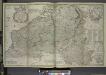
Les provinces des pays-bas Catholiques, ou a most exact map of Flanders or Austrian Netherlands &c.
from The world described, or, A new and correct sett of maps : shewing the kingdoms and states in all the known parts of the earth, with the principal cities, and most considerable towns in the world ... / ... by Herman Moll, geographer ...
XVII provinciae Belgii sive Germaniae inferioris priscis temporib. circulo Burgundico S. R. I. annumeratae quarum X. hodie maximam partem Hispaniarum non nullae Galliae regis ditioni subjacent, VII vero sub nomine foederatarum provinciar libertate gaudent
1 : 1050000 Belgie Seutter, Matthäus Mathaei Seutteri
Arena Martis in Belgio
1 : 830000 Mollova mapová sbírka Homann, Johann Baptist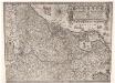
Inferioris Germaniae provinciarum nova descriptio / [Willem Jansz. Blaeu]
1 : 900000 Annotatie: Onder de titel een nadere omschrijving in het Latijn en Nederlands; Aan het oorspronkelijke kaartbeeld zijn het Bourtangerveen en Fort Bourtange toegevoegd; Lit.: Monumenta cartografica Neerlandica, IV, p. 31-32, 146-153, facs. 5; Oorspr. uitg.: 1604 Blaeu, Willem Jansz. Amstelodami : ex officina Guilielmi Johannis
Des Burgundischen Creisses Südlicher theil oder Oesterreichissche Niederlande
1 : 2250000 Mollova mapová sbírka Weigel, Christoph Weigel, Christoph I. - dědici
Belgivm Regivm accuratissime descriptum
1 : 1200000 Mollova mapová sbírka Weigel, Christoph Kauffer, Michael Weigel, Christoph I.
A map of the seat of war in France, with the country divided into its several departments
1 : 2600000
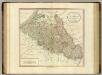
Netherlands, part of Germany.
1 : 880000 Cary, John, ca. 1754-1835