Maps of Belgium
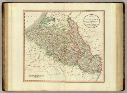
Netherlands, part of Germany.
1 : 880000 Cary, John, ca. 1754-1835
Netherlands, Germany W. of Rhine.
1 : 1620000 Darton, William
Les Provinces Apellées Pais Bas Connues Sous Les Noms De Flandre Et De Hollande
1 : 600000 Mollova mapová sbírka Fer, Nicolas de Loon, Herman van Fer, Nicolas de
Kriegsschauplatz der Niederlande eines Theils von Holland und am Rhein
Nizozemsko Lehnhardt
Kaart van de Nederlanden, Belgie, Luxemburg, Noordelijk Frankrijk en Westelijk Duitschland : ten gebruike van algemeene besturen, touristen, handelsreizigers, kantoren, instituten, enz. / vervaardigd ... onder toezicht en met medew. van J.A. van Voorthuijsen ; door A.A. en A.C. Nunnink
1 : 400000 J.A. van Voorthuijsen 1869 fl.; Albertus Anthonius Nunnink; Adolf Carel Nunnink 1813-1894 Brussel [etc.] : C. Muquardt
Carte du Royaume des Pays-Bas, comprenant les routes de poste et relais depuis Paris jusqu'aux frontières septentrionales de la Hollande, avec un Itinéraire des communications de Strasbourg à Amsterdam et Hambourg
1 : 1280000 [par] Hocquart. Paris : Audin
[Kaart], uit: Kaart der bevaarbare waterloopen van België, Nederland, N.-Frankrijk, W.-Duitschland, en den Rijn van Rotterdam tot Basel = Carte des voies navigables de la Belgique, la Hollande, N. de la France, Allemagne Est, et le Rhin de Rotterdam à Bâle = Wasserstrassen Karte von Belgien, Holland, N. Frankreich, W. Deutschland und der Rhein von Rotterdam bis Basel
1 : 800000 Antwerpen : Seghers
France
Map Western Front.
1 : 633600 C.S. Hammond & Company
Flanders or the Spanish Provinces.
from A new systeme of the mathematicks: containing I. Arithmetick, as well natural and decimal, as in species, or the principles of algebra. II. Practical geometry, together with the first six books of Euclid's Elements, as also the eleventh and twelfth, symbo
Holland and Belgium.
1 : 2080000 Tanner, Henry S.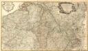
Frontieres de France et des Pais Bas
1 : 585000 Mollova mapová sbírka Fer, Nicolas de Fer, Nicolas de
Theatrum Belli Serenissimae Domus Austriacae
1 : 410000 Mollova mapová sbírka Oettinger, Johann Friedrich Seutter, Matthäus
Theatrum Belli Serenissimae Domus Austriacae
1 : 410000 Mollova mapová sbírka Oettinger, Johann Friedrich Seutter, Matthäus
Theatrum Belli Serenissimae Domus Austriacae
1 : 410000 Mollova mapová sbírka Oettinger, Johann Friedrich Seutter, Matthäus
Theatrum Belli Serenissimae Domus Austriacae
1 : 410000 Mollova mapová sbírka Oettinger, Johann Friedrich Seutter, Matthäus
Theatrum Belli Serenissimae Domus Austriacae
1 : 410000 Mollova mapová sbírka Oettinger, Johann Friedrich Seutter, Matthäus
Theatrum Belli Serenissimae Domus Austriacae
1 : 410000 Mollova mapová sbírka Oettinger, Johann Friedrich Seutter, Matthäus
Germania inferioris sive Belgii pars meridionalis exhibens X. provincias catholic. cum confiniis Galliae Germ. Hollandiae
Belgie Pinas, Carl Graf Vasquez Lotter, Tobias Conrad Tob. Conr. Lotter
Le Cours du Rhein
1 : 1100000 Mollova mapová sbírka Fer, Nicolas de Fer, Nicolas de
Leo Belgicus / Johan van Doetechum fecit
1 : 350000 Annotatie: Facs. van de uitg.: [Amsterdam] : C.J. Visscher excudit, 1650. - Het betreft de 3e staat van de kaart van J. van Doetechum uit 1598, bijgewerkt door C.J. Visscher; Uitg. t.g.v. de tentoonstelling "De wereld op papier", in het Amsterdams Historisch Museum, april 1967 Joannes van Doetecum de Oudere -1605; Visscher, Claes Jansz. [S.l. : s.n.]
Carte historique de la Belgique au moyen age / par Louis Delgeur
1 : 1135400 Delgeur, Louis [Bruxelles : Vandermaelen]
Zu den Feldzügen 1708 in den Niederlanden und am Rhein
Lille (Francie) Coxe, William K.k. Generalstabes
Niederlande und Belgien
Geographischer Atlas über alle Theile der Erde Ziegler, Jakob Melchior Verlag von Dietrich Reimer
Niederland und Belgien
Geographischer Atlas über alle Theile der Erde Ziegler, Jakob Melchior Verlag von Joh. Wurster um Comp.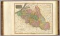
Belgium.
1 : 820000 Thomson, John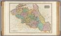
The Netherlands and the countries to the left bank of the Rhine.
1 : 655000 Pinkerton, John, 1758-1826
Schauplatz des dermahligen Krieges, 1793
1 : 2775000 Belgie Stöber, Joseph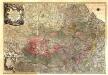
Theatrum Belli Serenissimae Domus Austriacae, Contra Gallos, Confine Limitibus Sacri Romani Imperii et Belgii
1 : 400000 Mollova mapová sbírka Oettinger, Johann Friedrich Lotter, Tobias Conrad Seutter, Matthäus
Holland And Belgium.
1 : 2100000 Tanner, Henry S.