Maps of Belgium

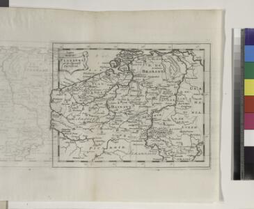
Flanders or the Spanish Provinces.
from A new systeme of the mathematicks: containing I. Arithmetick, as well natural and decimal, as in species, or the principles of algebra. II. Practical geometry, together with the first six books of Euclid's Elements, as also the eleventh and twelfth, symbo
Belgii XVII. Provintiarum. Universa Tabula Ad Usum Serenissimi Burgundiae Ducis
1 : 1000000 Mollova mapová sbírka Jaillot, Alexis-Hubert Jaillot, Alexis Hubert
Germaniae Cisrhenanae ut inter J. Caesaris et Trajani fuit imperia Scaldis item Mosae ac Rheni Ostiorum Antiqua descriptio.
1 : 2500000 [S.l.] : [s.n.]
Belgivm sive Inferior Germania
1 : 1500000 Mollova mapová sbírka Weigel, Christoph Goos, Abraham Weigel, Christoph I.
XVII. Provinciae Belgii sive Germaniae Inferioris
1 : 1100000 Mollova mapová sbírka Seutter, Matthäus Seutter, Matthäus
Tabula generalis totius Belgii qua provinciae XVII Infer. Germaniae olim sub S. R. I. circulo Burgundiae comprehensae nunc in Varias Potentias tum liberas utpote Prov. VII Foederatas, tum reliquas Hispaniae, et Galliae coronis subjectas, separata ostenduntur
1 : 1000000 Mollova mapová sbírka Homann, Johann Baptist Homann, Johann Baptista
Holland or the Seven United Provinces, and the Netherlands.
from Carey's general atlas, improved and enlarged : being a collection of maps of the world and quarters, their principal empires, kingdoms, &c.
Descriptio Germaniae Inferioris. [Karte], in: Theatrum orbis terrarum, S. 42.
1 Karte aus Atlas Ortelius, Abraham
[Recto], uit: Descriptio Germaniae Inferioris
1 : 1000000 Annotatie: Waarschijnlijk gegraveerd door F. Hogenberg; Uit: Theatrum Orbis Terrarm. - Antwerpen, 1570 Hogenberg, Franz [Antwerpen : Abraham Ortelius]
Descriptio Germaniae Inferioris. [Karte], in: Theatrum orbis terrarum, S. 162.
1 Karte aus Atlas Ortelius, Abraham Vrients, Jan Baptista
Nouvelle Carte du Royaume des Pays - Bas et Pays Limithropes...

67-68. North-East France, Belgium, Luxemburg. The World Atlas.
1 : 1250000 USSR (Union of Soviet Socialist Republics).
Unsere Westgrenze
1 : 1000000 Evropa západní Velhagen & Klasing
XVII provinciae Belgii sive Germaniae inferioris priscis temporib. circulo Burgundico S. R. I. annumeratae quarum X. hodie maximam partem Hispaniarum non nullae Galliae regis ditioni subjacent, VII vero sub nomine foederatarum provinciar libertate gaudent
1 : 1050000 Belgie Seutter, Matthäus Mathaei Seutteri
Belgii inferioris descriptio emendata cum circumiacentium regionum confiniis [Karte], in: Gerardi Mercatoris Atlas, sive, Cosmographicae meditationes de fabrica mundi et fabricati figura, S. 283.
1 Karte aus Atlas Mercator, Gerhard Montanus, Petrus
Belgica oder Nieder Teutschland
Belgie Baumgarten, Siegmund Jakob Johann Justinus Gebauer
Europe Centrale (Partie Occidentale).
1 : 1750000 Jouvet et Cie.
Homannův atlas světa
1 : 7000000
XVII Provinciae Belgii sive Germaniae Inferioris priscis temporibus circulo Burgundisco S.R.I. annumeratae quarum X hodie maximam partem Hispaniarum, non nullae Galliae regis ditioni subjacent, VII vero sub nomine Foederatarum Provinciarum Libertate gaudent
1 : 1250000 studio et opera Tobiae Conradi Lotter G. Rogg del. Augusta [Vindelicorum], : Tobiae Conradi Lotter
XVII Provinciae Belgii sive Germaniae Inferioris priscis temporibus Circulo Burgundico S. R. I. annumeratae, quarum X. hodie maximam partem Hispaniarum, non nullae Galliae Regis ditioni subiacent, VII. vero sub nomine Foederatarum Provinciar. libertate gaudent
1 : 1250000 studio et opera Matthaei Seutteri G. Rogg del. Augusta [Vind.] : Matthaeus Seutter

Nova mappa geographica Belgii universi seu Inferioris Germaniae quam XVII Provinciae, Austriaco, Gallico et Batavo sceptro parentes constituunt
1 : 1000000 cura et sum[p]tibus Joh: Michaelem Probst Aug. Vind. Aug. Vind : J.M. Probst
Leo Belgicus / Johan van Doetechum fecit
1 : 350000 Annotatie: Facs. van de uitg.: [Amsterdam] : C.J. Visscher excudit, 1650. - Het betreft de 3e staat van de kaart van J. van Doetechum uit 1598, bijgewerkt door C.J. Visscher; Uitg. t.g.v. de tentoonstelling "De wereld op papier", in het Amsterdams Historisch Museum, april 1967 Joannes van Doetecum de Oudere -1605; Visscher, Claes Jansz. [S.l. : s.n.]
The Spanish Netherlands.
from A system of geography, or, A new & accurate description of the earth in all its empires, kingdoms and states : illustrated with history and topography, and maps of every country : fairly engraven on copper, according to the latest discoveries and corrections / by Herman Moll.
Atlas für Handel und Industrie: Für Kaufleute, Fabrikante u. Gewerbetreibende, Handlungs- u. Gewerbe-Schulen


XVII provinciae Belgii sive Germaniae inferioris
1 : 1682000 Belgie Lotter, Tobias Conrad Rogg, Gottfried studio et opera Tobiae Conradi Lotter
XVII provinciae Belgii sive Germaniae inferioris
1 : 1682000 Belgie Lotter, Tobias Conrad Rogg, Gottfried opera Tobiae Conradi Lotter