Maps of Belgium

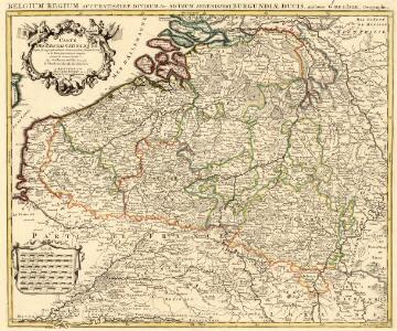
Belgium Regium Accuratissime Divisum. &c: Ad Usum Serenissimi Burgundiae Ducis. Authore G. de l'Isle, Geographe
1 : 710000 Mollova mapová sbírka Delisle, Guillaume Luchtenburg, Johannes van Covens, Johannes I
Des Burgundischen Creisses Südlicher theil oder Oesterreichissche Niederlande
1 : 2250000 Mollova mapová sbírka Weigel, Christoph Weigel, Christoph I. - dědici
Belgivm Regivm accuratissime descriptum
1 : 1200000 Mollova mapová sbírka Weigel, Christoph Kauffer, Michael Weigel, Christoph I.
BELGII REGII accuratissima Tabula
1 : 810000 Belgie Visscher, Nicolaus Nicolao Visscher
Arena Martis in Belgio
1 : 830000 Mollova mapová sbírka Homann, Johann Baptist
Belgii Pars Meridionalis
1 : 820000 Mollova mapová sbírka Visscher, Nicolaes Schenk, Pieter Schenk, Peter II
Germaniae inferioris sive Belgii pars meridionalis
1 : 853800 Belgie Lotter, Tobias Conrad M. Tob Conr. Lotter
Germaniae inferioris sive Belgii pars meridionalis
1 : 853800 Belgie Lotter, Tobias Conrad M. Tob Conr. Lotter
Belgii regii tabula
1 : 822000 Belgie Visscher, Nicolaes Jansz. per Nicolaum Visscher
Belgii Regii accuratissima Tabula. [Karte], in: Novus atlas absolutissimus, Bd. 3, S. 25.
1 Karte aus Atlas Janssonius Offizin
Arena martis in Belgio, qua provinciae X. catholicae inferioris Germaniae
1 : 850000 Belgie Homann, Johann Baptist J. B. Homann
Provinciae Belgii Regii Distinctae eo, quo Sunt hodie divisae modo Inter Regem Galiae, Hispaniae et Ordines Provinciarum Faederatarum
1 : 740000 Mollova mapová sbírka Danckerts, Justus Danckerts, Justus
Provinciae Belgii regii distinctae eo, quo sunt hodie divisae modo inter regem Galliae, Hispaniae et ordines provinciarum faederatarum tabula novissima et accuratissima
1 : 740000 1 Karte : Kupferdruck ; 49 x 56 cm Danckerts, Justus [Danckerts]
Circvlvs Bvrgvndicvs
1 : 732700 Belgie Mayer, Tobias Cassini de Thury Homannianis heredib.
Belgivm catholicvm seu Decem provinciae Germaniae inferioris
1 : 732700 Belgie Mayer, Tobias Cassini de Thury Homannianis heredib.
Netherlands or Low Countries.
1 : 980000 Bowen, Emanuel
Carte des Pais Bas Catholiqves ou des X Provinces de l'Allemagne Inferieure etc. dessinée au juste selon les exactes observations Astronimiques et Operations Geometriques des Mess. Cassini. Snelius. Muschenbrok etc. dresée par Sr. Tobias Maier. Mathematicien
1 : 725000 Mollova mapová sbírka Mayer, Tobias Homann, Johann Baptista - dědici
[104][107] Belgii Regii accuratissima tabula pluribus locis, uit: Atlas sive Descriptio terrarum orbis
Annotatie: Gedigitaliseerde versie. Amsterdam. Heiloo : Picturae (vervaardiger), 2015. tiff-bestand. Gedigitaliseerd: 07-01-2015; Origineel: Universiteitsbibliotheek Vrije Universiteit (XL.05127.-) ; Netherlands; Titelpagina ontbreekt Wit, Frederik de Amsterdam : Frederick de Wit

Belgique. Carte oro-hydrographique 1:500 000 = België oro-hydrografische kaart 1:500 000
1 : 500000 Ghellinck, A . de Turnhout : Brepols
Netherlands.
1 : 1670000 Seaman, James V.
Pay-Bas Autrichiens.
1 : 1020000 Clouet, J. B. L. (Jean-Baptiste Louis), b. 1730
(Les Pays-Bas autrichiens & francois)
1 : 5200000 Bruyset, Jean-Marie; Schneider, J. H.
Belgium Catholicum seu Decem Provinciae Germaniae Inferioris...

Provinciae Belgii regii
1 : 760000 Belgie Danckerts, Justus Iusto Danckerts
PROVINCIAE BELGII REGII
1 : 760000 Belgie Danckerts, Justus Iusto Danckerts
Les Provinces des Pays-Bas Catholiques [...] [Karte], in: Atlas nouveau, contenant toutes les parties du monde [...], Bd. 2, S. 20.
1 Karte aus Atlas Sanson, Nicolas Jaillot, Alexis Hubert und Mortier, Pieter
Nova totius Belgii regii tabula
1 : 762000 Belgie Wit, Frederick de Frederick de Wit