Maps of Belgium
Netherlands or Low Countries.
1 : 980000 Bowen, Emanuel
Des Burgundischen Creisses Südlicher theil oder Oesterreichissche Niederlande
1 : 2250000 Mollova mapová sbírka Weigel, Christoph Weigel, Christoph I. - dědici
Belgivm Regivm accuratissime descriptum
1 : 1200000 Mollova mapová sbírka Weigel, Christoph Kauffer, Michael Weigel, Christoph I.
Les Provinces des Pays-Bas Catholiques [...] [Karte], in: Atlas nouveau, contenant toutes les parties du monde [...], Bd. 2, S. 20.
1 Karte aus Atlas Sanson, Nicolas Jaillot, Alexis Hubert und Mortier, Pieter
Arena martis in Belgio, qua provinciae X. catholicae inferioris Germaniae
1 : 850000 Belgie Homann, Johann Baptist J. B. Homann
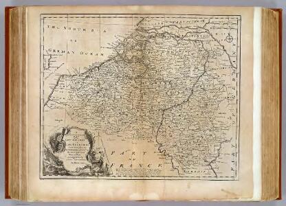
Les provinces des pays-bas Catholiques, ou a most exact map of Flanders or Austrian Netherlands &c.
from The world described, or, A new and correct sett of maps : shewing the kingdoms and states in all the known parts of the earth, with the principal cities, and most considerable towns in the world ... / ... by Herman Moll, geographer ...

The theatre of the present war in the Netherlands : being an improvement of a large map of the Low Countries by Mr. La Rouge : with the addition of the adjacent parts of England, Germany and the United Provinces
1 : 350000 Annotatie: Met plaatsnamenregister (met coördinaten en afstanden t.o.v. Londen, Parijs en Den Haag) London : printed for R. Wilkinson ... and Bowles & Carver
Arena Martis in Belgio
1 : 830000 Mollova mapová sbírka Homann, Johann Baptist
Provinciae Belgii regii
1 : 760000 Belgie Danckerts, Justus Iusto Danckerts
PROVINCIAE BELGII REGII
1 : 760000 Belgie Danckerts, Justus Iusto Danckerts
Provinciae Belgii Regii Distinctae eo, quo Sunt hodie divisae modo Inter Regem Galiae, Hispaniae et Ordines Provinciarum Faederatarum
1 : 740000 Mollova mapová sbírka Danckerts, Justus Danckerts, Justus
Provinciae Belgii regii distinctae eo, quo sunt hodie divisae modo inter regem Galliae, Hispaniae et ordines provinciarum faederatarum tabula novissima et accuratissima
1 : 740000 1 Karte : Kupferdruck ; 49 x 56 cm Danckerts, Justus [Danckerts]
Circvlvs Bvrgvndicvs
1 : 732700 Belgie Mayer, Tobias Cassini de Thury Homannianis heredib.
Belgivm catholicvm seu Decem provinciae Germaniae inferioris
1 : 732700 Belgie Mayer, Tobias Cassini de Thury Homannianis heredib.

Nieuwe en naukeurige kaart der tien catholijke Nederlanden, uit de beste autheuren en beroemste heedendaagsche kaarten opgemaakt, en volgens sterekundige waarnemingen in orde gebragt
1 : 850000 door Eman. Bowen verb. door W.A. Bachiene ; J. v. Jagen fecit, 1775 [Amsterdam] : [Matthijs Schalekamp]


Carte historique de la Belgique au moyen age / par Louis Delgeur
1 : 1135400 Delgeur, Louis [Bruxelles : Vandermaelen]
Belgium Catholicum seu Decem Provinciae Germaniae Inferioris...

Belgium Regium Accuratissime Divisum. &c: Ad Usum Serenissimi Burgundiae Ducis. Authore G. de l'Isle, Geographe
1 : 710000 Mollova mapová sbírka Delisle, Guillaume Luchtenburg, Johannes van Covens, Johannes I
Pays Bas meridionale.
1 : 970000 Janvier, Jean
Belgii Regii accuratissima Tabula. [Karte], in: Novus atlas absolutissimus, Bd. 3, S. 25.
1 Karte aus Atlas Janssonius Offizin
Belgique. Carte oro-hydrographique 1:500 000 = België oro-hydrografische kaart 1:500 000
1 : 500000 Ghellinck, A . de Turnhout : Brepols
Netherlands.
1 : 1670000 Seaman, James V.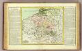
Pay-Bas Autrichiens.
1 : 1020000 Clouet, J. B. L. (Jean-Baptiste Louis), b. 1730
(Les Pays-Bas autrichiens & francois)
1 : 5200000 Bruyset, Jean-Marie; Schneider, J. H.
Germaniae inferioris sive Belgii pars meridionalis
1 : 853800 Belgie Lotter, Tobias Conrad M. Tob Conr. Lotter