Maps of Grand Est

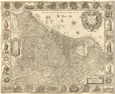
Belgii sive Germaniae accuratissima tabula
Mollova mapová sbírka Hondius, Henricus Janssonius, Johannes I
Neueste Generalkarte von Frankreich, 2
1 Blatt : 55 x 78 cm F.A. Schrämbl
Deuxieme feuille contenant la Flandre francoise, Picardie, Artois, Isle de France, Champagne, Lorraine et Alsace
1 Blatt : 39 x 57 cm Bourgoin
Flemmings Spezialkarte für den deutsch-französischen Krieg
1 : 600000 Evropa západní Carl Flemming
Skizze zur Orientirung ϋber den Feldzug 1807
Carte Physique et Militaire de la Frontiere du Nord-Est.
1 : 1000000 Jouvet et Cie.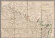
A map of the northern part of France to facilitate the knowledge of the operations carried out by the allied armies against the French Conventional troops
1 : 640000 London : William Faden
Théatre de la guerre actuelle, en Allemagne, en Pologne et en Turquie. n9
1 : 900000 Chanlaire, Pierre Grégoire 1758-1817 Paris : chez l'auteur P. G. Chanlaire
France Flle. N.E.
1 : 1000000 Vivien St Martin, L.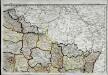
Carte de la république de France, no. 2
1 Blatt : 41 x 58 cm s.n.
Allgemeine Uebersicht des Kriegsschauplazes am Rhein, der Mosel, Maas, Marne, Seine, Schelde [et].c.c
1 Karte : Kupferdruck ; 48 x 58 cm Güssefeld bey d. Homann. Erben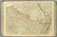
N. France.
1 : 680000 Faden, William, 1750?-1836
Paasche's Frontenkarte, Nr.13. Der Krieg gegen Russland

Zu den Feldzügen 1708 in den Niederlanden und am Rhein
Lille (Francie) Coxe, William K.k. Generalstabes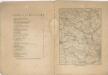
Kriegs Atlas 36 Karten von den Schauplätzen des Weltkrieges 1914/1915

Western Front. Front line on March 20th, Aug.16th, Sept. 18th 1918.
1 : 600000 First World War map of the Western Front. Front line on March 20th, Aug.16th, Sept. 18th 1918. Shows limits of German advance in 1918. War Office
[Nordostfrankreich]
1 Karte : Kupferdruck ; 37 x 56 cm Chanlaire chez l'auteur P. G. Chanlaire rue Geoffroy-Langevin no. 7

Einsatz der 1./Pz. Rgt. 2 im Westen vom 10. 5. - 6. 9. 1940
Francie Veit Carl Kaestner
The Western Front. June 1918.
1 : 600000 First World War map of the Western Front. June 1918. Front Line June 12th, June 5th and March 20th. War Office
France 2.
1 : 1774080 Letts, Son & Co.
Frankreich NO.
1 : 1700000 Berghaus, Heinrich; Flemming, Carl; Handtke, Friedrich H.; Sohr, Karl
[104][107] Belgii Regii accuratissima tabula pluribus locis, uit: Atlas sive Descriptio terrarum orbis
Annotatie: Gedigitaliseerde versie. Amsterdam. Heiloo : Picturae (vervaardiger), 2015. tiff-bestand. Gedigitaliseerd: 07-01-2015; Origineel: Universiteitsbibliotheek Vrije Universiteit (XL.05127.-) ; Netherlands; Titelpagina ontbreekt Wit, Frederik de Amsterdam : Frederick de Wit
Carte des Pays-Bas Autrichiens
1 : 800000 Belgie Mentelle, Edme Tardieu, Pierre François

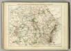
Karte von Frankreich in XVI Blättern, No. 3 und [No. 7]
2 Blätter : 53 x 34 cm Königl. Preuss. Academischen Kunst und Buchhandlung
Province de Cologne, dans la Gaule Belgicque de laquelle
1 : 875000 Mollova mapová sbírka Sanson, Nicolas Mariette, Pierre
1:500,000 Europe (Air) G.S.G.S. No. 4072, Paris
Sheet NE48-2 from the map series: 1:500,000 Europe (Air) G.S.G.S. No. 4072.