Maps of gmina Walim

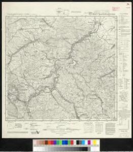
Meßtischblatt 3074, neue Nr. 5264 : Bad Charlottenbrunn, 1939
1 : 250000 Bad Charlottenbrunn. - Aufn. 1881, hrsg. 1883, bericht. 1937, redakt. Änd. [19]38. - 1:25000. - [Berlin]: Reichsamt für Landesaufnahme, 1939. - 1 Kt.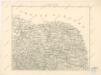
Podrobná místopisná mapa Království Českého

Podrobná mapa Království českého
1 : 100000 Broumov (Náchod, Česko : oblast) Srp, Jan Jaroslav Bursík
[Kartenblatt]
1 : 25000 Broumov (Náchod, Česko : oblast) Reichsamt für Landesaufnahme
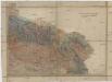
III. vojenské mapování 3757
1 : 75000
III. vojenské mapování 3757
1 : 75000
Šonov
1 : 75000 Čechy (Česko) Vojenský zeměpisný ústav
Sec. Waldenburg
1 : 100000 Königliches Lithographisches Institut (Berlin) Simon Schroppsche Landkartenhndl.
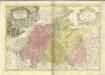
Das Fürstenthum Schweidnitz in Nieder-Schlesien
1 : 290000 Svídnice-oblast (Polsko) Wieland, Johann Wolfgang Schleuen, Johann David I.D. Schleuen
Das Fürstenthum Schweidnitz in Nieder Schlesien
1 : 300000 Mollova mapová sbírka Schleuen, Johann David Schleuen, Johann David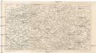
Krkonoše
Krkonoše (Česko a Polsko) Kohut, Josef Líčka, Josef nákladem Františka Řivnáče
Dvcatvs Silesiae Schwidnicensis
1 : 172500 Mollova mapová sbírka Kuhn, Friedrich Schenk, Peter I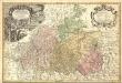
Principatvs Silesiae Schwidnicensis Secundum ejusdem Circvlos Schweidnitz, Striegav, Bolckenhain, Landeshut & Reichenbach divisi et Geometr.
1 : 125000 Mollova mapová sbírka Wieland, Johann Wolfgang Homann, Johann Baptista - dědici
133. Schweidnitz, uit: Topographische Uebersichtskarte des Deutschen Reiches / herausgegeben v. d. Kartogr. Abt. d. Königl. Preuß. Landesaufnahme
1 : 200000 titelvariant: Topogr. Übersichtskarte des Deutschen Reiches; Annotatie: Titel boven bladen ook: Topogr. Übersichtskarte des Deutschen Reiches; Annotatie geografische gegevens: Op elk blad twee maatstokken: 10 Kilometer = 5,5 cm; 1 geogr. Meile = 3,6 cm; Legenda onder op elk blad Königlich Preußische Landesaufnahme. Kartographische Abtheilung [S.l : Königlich Preußische Landesaufnahme, Kartographische Abtheilung]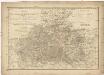
Das Fürstenthum Schweidnitz
1 : 130000 Slezsko Sotzmann, Daniel Friedrich Fembo, Christoph Christoph Fembo
[Nová Mapa království Českého]
1 : 200000 Krkonoše (Česko a Polsko) Kotyška, Václav Hanf, Norbert Bursík & Kohout
Nová Mapa království Českého
1 : 200000 Čechy severovýchodní (Česko) Kotyška, Václav Hanf, Norbert Bursík & Kohout

Comitatus Glatz [Karte], in: Novus Atlas, das ist, Weltbeschreibung, Bd. 1, S. 185.
1 Karte aus Atlas Blaeu, Joan Blaeu, Willem Janszoon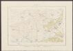
Comitatus Glatz [Karte], in: Theatrum orbis terrarum, sive, Atlas novus, Bd. 1, S. 150.
1 Karte aus Atlas Blaeu, Joan Blaeu, Willem Janszoon
DVCATVS | SILESIÆ | SCHWIDNICENSIS
Authore Friduico Kuhnovio | Bolco-lucano Silesio. [Amsterdam : Joan Blaeu]
Comitatus Glatz [Karte], in: Novus atlas absolutissimus, Bd. 2, S. 247.
1 Karte aus Atlas Janssonius Offizin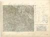
Generalkarte zum Kriegsspielplan von Trautenau
Landesdurchforschung von Böhmen
1 : 144000 Krkonoše-oblast (Česko a Polsko) Kořistka, Karel František Edvard
Generální mapa ČSR

[A. Bidschover und B. Königingratzer Kreis samt der Grafschaft Glatz]
1 : 175000 Hradec Králové-oblast (Česko) Franza, Petr Peter franza [sic]
A. Bidschover und B. Königingratzer Kreis samt der Grafschaft Glatz
1 : 175000 Hradec Králové-oblast (Česko)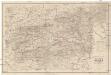
Special Karte der Grafschaft Glatz nebst angrenzenden Theilen von Böhmen und Mähren etc
1 : 150000 Kladsko-oblast (Polsko) Liebenow, W. Eduard Trewendt