Maps of powiat strzeliński

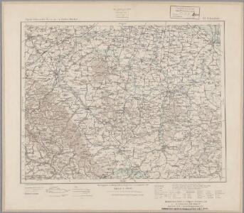
133. Schweidnitz, uit: Topographische Uebersichtskarte des Deutschen Reiches / herausgegeben v. d. Kartogr. Abt. d. Königl. Preuß. Landesaufnahme
1 : 200000 titelvariant: Topogr. Übersichtskarte des Deutschen Reiches; Annotatie: Titel boven bladen ook: Topogr. Übersichtskarte des Deutschen Reiches; Annotatie geografische gegevens: Op elk blad twee maatstokken: 10 Kilometer = 5,5 cm; 1 geogr. Meile = 3,6 cm; Legenda onder op elk blad Königlich Preußische Landesaufnahme. Kartographische Abtheilung [S.l : Königlich Preußische Landesaufnahme, Kartographische Abtheilung]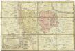
Principatvs Silesiae Mvnsterbergensis exactissima tabula geographica exhibens circulos ejusdem Mvnsterberg et Frankenstein una cum adjacentibus civitatibus Reichenstein et Silberberg ad principatum bregensem alias pertinentibus
1 : 100000 Slezsko Wieland, Johann Wolfgang Schubarth, Matthäus Homannianos Heredes
Broumov a Reichenbach i. Schles
1 : 75000 Broumov (Náchod, Česko : oblast) Vojenský zeměpisný ústav
Schönau bei Bhm. Braunau
1 : 75000 Broumov (Náchod, Česko : oblast) Bloschitz, R. K. u. k. Militärgeographisches Institut
Schönau bei B[ö]hm[isch] Branau
1 : 75000 Čechy (Česko) K. u. k. Militärgeographisches Institut
170 Glatz, uit: Topographische Special-Karte von Deutschland (von Central-Europa) / begründet von D.G. Reymann ; [entworfen und gezeichn. von Heinrich Berghaus... [et al.]]
1 : 200000 Annotatie: Lit.: Daniel Gottlob Reymann und die "Topographische Special-Karte von Deutschland" / von Wolfgang Scharfe, in: Kartographische Nachrichten, 39 (1989), Heft I, p. 1-10; Handgeschreven titel: Reymann's Deutschland : 24 Sectionen: Jena, Penig, Dresden, Zittau, Hirschberg, Breslau, Brieg, Andernach, Coblenz, Giessen, Fulda, Schleusingen, Plauen, Zwickau, Teplitz, Jung Bunzlau, Hohenelbe, Glatz, Neisse, Simmern, Prag, Luxemburg, Birkenfeld; Aanwezig: 23 bladen Reymann, Daniel Gottlob; Berghaus, Heinrich [Berlin : 2. Departement des Kriegsministeriums, Bureau für Plan- und Kartenzeichnung]
Schonau Bei Bhm. Braunau.
from Spezialkarte der osterreichisch-ungarischen Monarchie.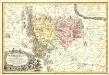
Principatvs Silesiae Mvnsterbregensis exactissima Tabula Geographica exhibens :
1 : 870000 Mollova mapová sbírka Wieland, Johann Wolfgang Homann, Johann Baptista - dědici
Special-Carte des Fürstenthums Grotkau oder Neisse in Ober-Schlesien, an den Böhmischen und Mährischen Grentzen
Mollova mapová sbírka Schleuen, Johann David Schleuen, Johann David
III. vojenské mapování 3757
1 : 75000
III. vojenské mapování 3757
1 : 75000
Šonov
1 : 75000 Čechy (Česko) Vojenský zeměpisný ústav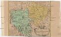
Das Fürstenthum Münsterberg in Nieder-Schlesien
1 : 170000 Dolní Slezsko Schleuen, Johann David I.D. Schleuen

Das Fürstenthum Münsterberg in Nieder-Schlesien
Mollova mapová sbírka Schleuen, Johann David
Geologische Übersichtskarte des Zobtengebietes
1 : 100000 Finckh, Ludwig. Preuß. Geol. Landesanstalt
Plaan der merkwrüdigen Stellung drey grossen Armeen
1 : 100000 Svídnice-oblast (Polsko) Mayer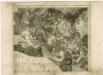
Müllerova mapa Čech V
1 : 132000
[Kartenblatt]
1 : 25000 Broumov (Náchod, Česko : oblast) Reichsamt für Landesaufnahme
[Kartenblatt]
1 : 25000 Božanov (Česko) Reichsamt für Landesaufnahme
[Schweidnitz und Umgebung]
1 : 100000 Svídnice (Polsko : oblast)
[Manoeuvre bey Ohlau]

Meßtischblatt 3192 : Lindenau, 1919
1 : 250000 Lindenau. - Aufn. 1883, kl. Nachtr. 1919. - 1:25000. - [Berlin]: Reichsamt für Landesaufnahme, 1919. - 1 Kt.
Meßtischblatt 3191 : Kamenz in Niederschlesien, 1936
1 : 250000 Kamenz in Niederschlesien. - Hrsg. 1884, einz. Nachtr. 1929, gedr. [19]36. - 1:25000. - [Berlin]: Reichsamt für Landesaufnahme, 1936. - 1 Kt.
Meßtischblatt 3189 : Neurode, 1934
1 : 250000 Neurode. - Aufn. 1929, hrsg. 1934. - 1:25000. - [Berlin]: Reichsamt für Landesaufnahme, 1934. - 1 Kt.
Meßtischblatt 3188 : Wünschelburg, 1937
1 : 250000 Wünschelburg. - Hrsg. 1936, einz. Nachtr. 1937. - 1:25000. - [Berlin]: Reichsamt für Landesaufnahme, 1937. - 1 Kt.
Meßtischblatt 3188 : Wünschelburg, 1919
1 : 250000 Wünschelburg. - Aufn. 1881, bericht. 1919. - 1:25000. - [Berlin]: Preuss. Landesaufnahme, 1919. - 1 Kt.
Meßtischblatt 3188 : Wünschelburg, 1883
1 : 250000 Wünschelburg. - Aufn. 1881. - 1:25000. - [Berlin]: Kgl. Preuss. Landesaufnahme, 1883. - 1 Kt.
Meßtischblatt 5469 : Bechau, 1938
1 : 250000 Bechau. - Aufn. 1883, hrsg. 1884, bericht. 1938. - 1:25000. - [Berlin]: Reichsamt für Landesaufnahme, 1938. - 1 Kt.