Maps of Czerwieńczyce

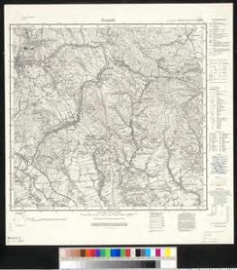
Meßtischblatt 3189 : Neurode, 1934
1 : 250000 Neurode. - Aufn. 1929, hrsg. 1934. - 1:25000. - [Berlin]: Reichsamt für Landesaufnahme, 1934. - 1 Kt.
[Kartenblatt]
1 : 25000 Božanov (Česko) Reichsamt für Landesaufnahme
III. vojenské mapování 3757
1 : 75000
III. vojenské mapování 3757
1 : 75000
Schönau bei Bhm. Braunau
1 : 75000 Broumov (Náchod, Česko : oblast) Bloschitz, R. K. u. k. Militärgeographisches Institut
Schönau bei B[ö]hm[isch] Branau
1 : 75000 Čechy (Česko) K. u. k. Militärgeographisches Institut
Schonau Bei Bhm. Braunau.
from Spezialkarte der osterreichisch-ungarischen Monarchie.
Broumov a Reichenbach i. Schles
1 : 75000 Broumov (Náchod, Česko : oblast) Vojenský zeměpisný ústav
Šonov
1 : 75000 Čechy (Česko) Vojenský zeměpisný ústav
Generalkarte der Bezirkshauptmannschaft Braunau
1 : 220000 Broumov-oblast (Náchod, Česko) Wagner, Jan Eduard F. Kytka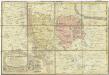
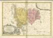
Principatvs Silesiae Mvnsterbergensis exactissima tabula geographica exhibens circulos ejusdem Mvnsterberg et Frankenstein una cum adjacentibus civitatibus Reichenstein et Silberberg ad principatum bregensem alias pertinentibus
1 : 100000 Slezsko Wieland, Johann Wolfgang Schubarth, Matthäus Homannianos Heredes
170 Glatz, uit: Topographische Special-Karte von Deutschland (von Central-Europa) / begründet von D.G. Reymann ; [entworfen und gezeichn. von Heinrich Berghaus... [et al.]]
1 : 200000 Annotatie: Lit.: Daniel Gottlob Reymann und die "Topographische Special-Karte von Deutschland" / von Wolfgang Scharfe, in: Kartographische Nachrichten, 39 (1989), Heft I, p. 1-10; Handgeschreven titel: Reymann's Deutschland : 24 Sectionen: Jena, Penig, Dresden, Zittau, Hirschberg, Breslau, Brieg, Andernach, Coblenz, Giessen, Fulda, Schleusingen, Plauen, Zwickau, Teplitz, Jung Bunzlau, Hohenelbe, Glatz, Neisse, Simmern, Prag, Luxemburg, Birkenfeld; Aanwezig: 23 bladen Reymann, Daniel Gottlob; Berghaus, Heinrich [Berlin : 2. Departement des Kriegsministeriums, Bureau für Plan- und Kartenzeichnung]
Die Grafschaft Glatz
1 : 460000 Kladsko (Polsko : oblast) Schreiber, Johann Georg J.G. Schreibern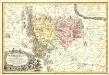
Principatvs Silesiae Mvnsterbregensis exactissima Tabula Geographica exhibens :
1 : 870000 Mollova mapová sbírka Wieland, Johann Wolfgang Homann, Johann Baptista - dědici
Die souveraine Graffschaft Glatz an der Schlesischen Gräntze
Kladsko-oblast (Polsko) Schleuen, Johann David I.D. Schleuen
133. Schweidnitz, uit: Topographische Uebersichtskarte des Deutschen Reiches / herausgegeben v. d. Kartogr. Abt. d. Königl. Preuß. Landesaufnahme
1 : 200000 titelvariant: Topogr. Übersichtskarte des Deutschen Reiches; Annotatie: Titel boven bladen ook: Topogr. Übersichtskarte des Deutschen Reiches; Annotatie geografische gegevens: Op elk blad twee maatstokken: 10 Kilometer = 5,5 cm; 1 geogr. Meile = 3,6 cm; Legenda onder op elk blad Königlich Preußische Landesaufnahme. Kartographische Abtheilung [S.l : Königlich Preußische Landesaufnahme, Kartographische Abtheilung]

Monumenta Cartographica Bohemiae II.: Müllerova mapa

Kladsko
1 : 200000 Kladsko-oblast (Polsko) Service cartogr. de l ́Armee Tcheco-Sl.
COMITATVS | GLATZ
Authore Jona Sculteto. [Amsterdam : Joan Blaeu]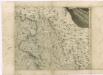
Müllerova mapa Čech
1 : 132000
Comitatus Glacensis
Kladsko-oblast (Polsko) Glocksperger, Johannes per Johannem Glocksperger
[Glatz]
Kladsko-oblast (Polsko) Kreibich, František Jakub Jindřich

Comitatus Glaciensis tabula geogr
1 : 160000 Kladsko-oblast (Polsko) Mayer, Tobias edentibus Homannianis Heredibus
Comitatus Glaciensis tabula geogr
1 : 150000 Kladsko-oblast (Polsko) Mayer, Tobias Homannianos Heredes
Comitatus Glaciensis tabula geogr
1 : 160000 Kladsko-oblast (Polsko) Mayer, Tobias edentibus Homannianis Heredibus