Maps of gmina Nowa Ruda

Šonov
1 : 75000 Čechy (Česko) Vojenský zeměpisný ústav
III. vojenské mapování 3757
1 : 75000
III. vojenské mapování 3757
1 : 75000
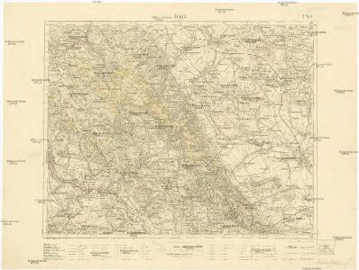
Schönau bei Bhm. Braunau
1 : 75000 Broumov (Náchod, Česko : oblast) Bloschitz, R. K. u. k. Militärgeographisches Institut
Schönau bei B[ö]hm[isch] Branau
1 : 75000 Čechy (Česko) K. u. k. Militärgeographisches Institut
Broumov a Reichenbach i. Schles
1 : 75000 Broumov (Náchod, Česko : oblast) Vojenský zeměpisný ústav
[Kartenblatt]
1 : 25000 Broumov (Náchod, Česko : oblast) Reichsamt für Landesaufnahme
[Kartenblatt]
1 : 25000 Božanov (Česko) Reichsamt für Landesaufnahme
Meßtischblatt 5365 : Langenbielau, 1937
1 : 250000 Langenbielau. - Aufn. 1928/29, hrsg. 1936, einz. Nachtr. 1937. - 1:25000. - [Berlin]: Reichsamt für Landesaufnahme, 1937. - 1 Kt.
Meßtischblatt 5364 : Wüstegiersdorf, 1937
1 : 250000 Wüstegiersdorf. - Aufn. 1930, hrsg. 1934, einz. Nachtr. 1937. - 1:25000. - [Berlin]: Reichsamt für Landesaufnahme, 1937. - 1 Kt.
Meßtischblatt 3189 : Neurode, 1934
1 : 250000 Neurode. - Aufn. 1929, hrsg. 1934. - 1:25000. - [Berlin]: Reichsamt für Landesaufnahme, 1934. - 1 Kt.
Meßtischblatt 3188 : Wünschelburg, 1937
1 : 250000 Wünschelburg. - Hrsg. 1936, einz. Nachtr. 1937. - 1:25000. - [Berlin]: Reichsamt für Landesaufnahme, 1937. - 1 Kt.
Meßtischblatt 3188 : Wünschelburg, 1919
1 : 250000 Wünschelburg. - Aufn. 1881, bericht. 1919. - 1:25000. - [Berlin]: Preuss. Landesaufnahme, 1919. - 1 Kt.
Meßtischblatt 3188 : Wünschelburg, 1883
1 : 250000 Wünschelburg. - Aufn. 1881. - 1:25000. - [Berlin]: Kgl. Preuss. Landesaufnahme, 1883. - 1 Kt.
III. vojenské mapování 3757/3
1 : 25000
[Gradkartenblatt]
1 : 25000 Broumov-oblast (Náchod, Česko) Vojenský zeměpisný ústav
Meßtischblatt 3135 : Gnadenfrei, 1933
1 : 250000 Gnadenfrei. - Hrsg. 1883, bericht. 1926, gedr. [19]33. - 1:25000. - [Berlin]: Reichsamt für Landesaufnahme, 1933. - 1 Kt.
Meßtischblatt 3190 : Frankenstein, 1932
1 : 250000 Frankenstein. - Hrsg. 1883, bericht. 1919, einz. Nachtr. 1926, gedr. [19]32. - 1:25000. - [Berlin]: Reichsamt für Landesaufnahme, 1932. - 1 Kt.
Meßtischblatt 3190 : Frankenstein, 1919
1 : 250000 Frankenstein. - Aufn. 1881, bericht. 1919. - 1:25000. - [Berlin]: Preuss. Landesaufnahme, 1919. - 1 Kt.
Schönau (Ssonow) - c7754-1-002 - Kaiserpflichtexemplar der Landkarten des stabilen Katasters
1 : 2880
Schönau (Ssonow) - c7754-1-011 - Kaiserpflichtexemplar der Landkarten des stabilen Katasters
1 : 2880
Schönau (Ssonow) - c7754-1-006 - Kaiserpflichtexemplar der Landkarten des stabilen Katasters
1 : 2880
Schönau (Ssonow) - c7754-1-001 - Kaiserpflichtexemplar der Landkarten des stabilen Katasters
1 : 2880
Schönau (Ssonow) - c7754-1-005 - Kaiserpflichtexemplar der Landkarten des stabilen Katasters
1 : 2880
Schönau (Ssonow) - c7754-1-008 - Kaiserpflichtexemplar der Landkarten des stabilen Katasters
1 : 2880
Schönau (Ssonow) - c7754-1-007 - Kaiserpflichtexemplar der Landkarten des stabilen Katasters
1 : 2880
Schönau (Ssonow) - c7754-1-004 - Kaiserpflichtexemplar der Landkarten des stabilen Katasters
1 : 2880
Schönau (Ssonow) - c7754-1-010 - Kaiserpflichtexemplar der Landkarten des stabilen Katasters
1 : 2880
Schönau (Ssonow) - c7754-1-003 - Kaiserpflichtexemplar der Landkarten des stabilen Katasters
1 : 2880