Maps of powiat świdnicki

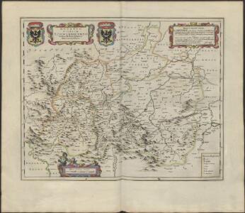
DVCATVS | SILESIÆ | SCHWIDNICENSIS
Authore Friduico Kuhnovio | Bolco-lucano Silesio. [Amsterdam : Joan Blaeu]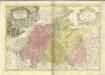

Principatvs Silesiae Schwidnicensis Secundum ejusdem Circvlos Schweidnitz, Striegav, Bolckenhain, Landeshut & Reichenbach divisi et Geometr.
1 : 125000 Mollova mapová sbírka Wieland, Johann Wolfgang Homann, Johann Baptista - dědici
Dvcatvs Silesiae Schwidnicensis
1 : 172500 Mollova mapová sbírka Kuhn, Friedrich Schenk, Peter I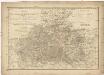
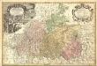
Das Fürstenthum Schweidnitz
1 : 130000 Slezsko Sotzmann, Daniel Friedrich Fembo, Christoph Christoph Fembo
Generální mapa ČSR

Das Fürstenthum Schweidnitz in Nieder Schlesien
1 : 300000 Mollova mapová sbírka Schleuen, Johann David Schleuen, Johann David
Das Fürstenthum Schweidnitz in Nieder-Schlesien
1 : 290000 Svídnice-oblast (Polsko) Wieland, Johann Wolfgang Schleuen, Johann David I.D. Schleuen
Sec. Waldenburg
1 : 100000 Königliches Lithographisches Institut (Berlin) Simon Schroppsche Landkartenhndl.
151 Breslau, uit: Topographische Special-Karte von Deutschland (von Central-Europa) / begründet von D.G. Reymann ; [entworfen und gezeichn. von Heinrich Berghaus... [et al.]]
1 : 200000 Annotatie: Lit.: Daniel Gottlob Reymann und die "Topographische Special-Karte von Deutschland" / von Wolfgang Scharfe, in: Kartographische Nachrichten, 39 (1989), Heft I, p. 1-10; Handgeschreven titel: Reymann's Deutschland : 24 Sectionen: Jena, Penig, Dresden, Zittau, Hirschberg, Breslau, Brieg, Andernach, Coblenz, Giessen, Fulda, Schleusingen, Plauen, Zwickau, Teplitz, Jung Bunzlau, Hohenelbe, Glatz, Neisse, Simmern, Prag, Luxemburg, Birkenfeld; Aanwezig: 23 bladen Reymann, Daniel Gottlob; Berghaus, Heinrich [Berlin : 2. Departement des Kriegsministeriums, Bureau für Plan- und Kartenzeichnung]
Grundriß der schlesischen Hauptstadt Bresslau
1 : 142000 Vratislav-oblast (Polsko) Trattner, Johann Thomas Johann Thomas Trattner
Liegnitz-Hirschberg (Riesengebirge)
1 : 100000 Jelení Hora-oblast (Polsko) Reichsamt für Landesaufnahme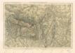
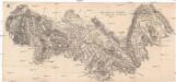
Riesengebirge
Müllerova mapa Čech V
1 : 132000
Specialkarte des Riesengebirges
1 : 75000 Krkonoše (Česko a Polsko : pohoří : oblast) Section Riesengebirge des Gebirgvereines für Böhmen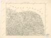
Podrobná místopisná mapa Království Českého

Östliche Riesengebirge und die Adersbach-Wekelsdorfer Felsen
1 : 100000 Adršpašsko-teplické skály (Česko) G. Freytag & Berndt
Gegend zwischen Schatzlar Golden-Else und Wekelsdorf
Žacléř-oblast (Česko)
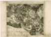
Plaan der merkwrüdigen Stellung drey grossen Armeen
1 : 100000 Svídnice-oblast (Polsko) Mayer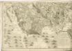
Topographische und Militairische Carte desienigen Theils von Boehmen...

Podrobná mapa Království českého
1 : 100000 Broumov (Náchod, Česko : oblast) Srp, Jan Jaroslav Bursík
Vilímkovy místopisné mapy zemí Koruny české
1 : 100000 Broumov (Náchod, Česko : oblast) Srp, Jan Jos. R. Vilímek
Generalkarte der Bezirkshauptmannschaft Braunau
1 : 220000 Broumov-oblast (Náchod, Česko) Wagner, Jan Eduard F. Kytka
Schonau Bei Bhm. Braunau.
from Spezialkarte der osterreichisch-ungarischen Monarchie.
Trautenau und Politz.
from Spezialkarte der osterreichisch-ungarischen Monarchie.
Trautenau und Politz
1 : 75000 Broumov (Náchod, Česko : oblast) Fenzl K. u. k. Militärgeographisches Institut
Trautenau und Politz
1 : 75000 Police nad Metují (Česko : oblast) K. u. k. Militärgeographisches Institut