Maps of powiat świdnicki

Principatvs Silesiae Schwidnicensis Secundum ejusdem Circvlos Schweidnitz, Striegav, Bolckenhain, Landeshut & Reichenbach divisi et Geometr.
1 : 125000 Mollova mapová sbírka Wieland, Johann Wolfgang Homann, Johann Baptista - dědici
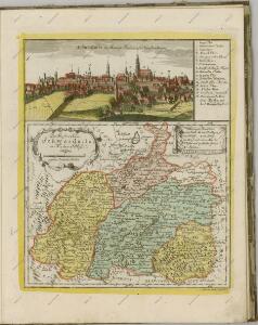
DVCATVS | SILESIÆ | SCHWIDNICENSIS
Authore Friduico Kuhnovio | Bolco-lucano Silesio. [Amsterdam : Joan Blaeu]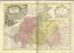

Generální mapa ČSR

Dvcatvs Silesiae Schwidnicensis
1 : 172500 Mollova mapová sbírka Kuhn, Friedrich Schenk, Peter I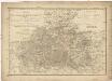
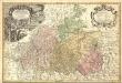
Das Fürstenthum Schweidnitz
1 : 130000 Slezsko Sotzmann, Daniel Friedrich Fembo, Christoph Christoph Fembo
Das Fürstenthum Schweidnitz in Nieder Schlesien
1 : 300000 Mollova mapová sbírka Schleuen, Johann David Schleuen, Johann David
Das Fürstenthum Schweidnitz in Nieder-Schlesien
1 : 290000 Svídnice-oblast (Polsko) Wieland, Johann Wolfgang Schleuen, Johann David I.D. Schleuen
151 Breslau, uit: Topographische Special-Karte von Deutschland (von Central-Europa) / begründet von D.G. Reymann ; [entworfen und gezeichn. von Heinrich Berghaus... [et al.]]
1 : 200000 Annotatie: Lit.: Daniel Gottlob Reymann und die "Topographische Special-Karte von Deutschland" / von Wolfgang Scharfe, in: Kartographische Nachrichten, 39 (1989), Heft I, p. 1-10; Handgeschreven titel: Reymann's Deutschland : 24 Sectionen: Jena, Penig, Dresden, Zittau, Hirschberg, Breslau, Brieg, Andernach, Coblenz, Giessen, Fulda, Schleusingen, Plauen, Zwickau, Teplitz, Jung Bunzlau, Hohenelbe, Glatz, Neisse, Simmern, Prag, Luxemburg, Birkenfeld; Aanwezig: 23 bladen Reymann, Daniel Gottlob; Berghaus, Heinrich [Berlin : 2. Departement des Kriegsministeriums, Bureau für Plan- und Kartenzeichnung]
Sec. Waldenburg
1 : 100000 Königliches Lithographisches Institut (Berlin) Simon Schroppsche Landkartenhndl.
Grundriß der schlesischen Hauptstadt Bresslau
1 : 142000 Vratislav-oblast (Polsko) Trattner, Johann Thomas Johann Thomas Trattner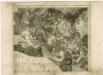
Müllerova mapa Čech V
1 : 132000

Specialkarte des Riesengebirges
1 : 75000 Krkonoše (Česko a Polsko : pohoří : oblast) Section Riesengebirge des Gebirgvereines für Böhmen
Plaan der merkwrüdigen Stellung drey grossen Armeen
1 : 100000 Svídnice-oblast (Polsko) Mayer
Podrobná místopisná mapa Království Českého

Geologische Übersichtskarte des Zobtengebietes
1 : 100000 Finckh, Ludwig. Preuß. Geol. Landesanstalt
[Kartenblatt]
1 : 25000 Adršpach (Česko : oblast) Reichsamt für Landesaufnahme
[Kartenblatt]
1 : 25000 Adršpach (Česko : oblast) Reichsamt für Landesaufnahme
[Gradkartenblatt]
1 : 25000 Krkonoše (Česko a Polsko) Vojenský zeměpisný ústav
Conradvs Ernest Maximilianvs S.R.I. Comes de Hochberg Liber Baro in et de Fürstenstein Dynasta Dynastiarvm Fürstenstein et Friedland
Mollova mapová sbírka Spanninger, J. G. V. Tscherning, Jan
Östliche Riesengebirge und die Adersbach-Wekelsdorfer Felsen
1 : 100000 Adršpašsko-teplické skály (Česko) G. Freytag & Berndt
Podrobná mapa Království českého
1 : 100000 Broumov (Náchod, Česko : oblast) Srp, Jan Jaroslav Bursík
Topographische und Militairische Carte desienigen Theils von Boehmen...

Vilímkovy místopisné mapy zemí Koruny české
1 : 100000 Broumov (Náchod, Česko : oblast) Srp, Jan Jos. R. Vilímek
III. vojenské mapování 3757
1 : 75000
Trautenau und Politz
1 : 75000 Broumov (Náchod, Česko : oblast) Fenzl K. u. k. Militärgeographisches Institut
Trautenau und Politz
1 : 75000 Police nad Metují (Česko : oblast) K. u. k. Militärgeographisches Institut