Maps of gmina Mieroszów

Podrobná mapa Království českého
1 : 100000 Broumov (Náchod, Česko : oblast) Srp, Jan Jaroslav Bursík
Topographische und Militairische Carte desienigen Theils von Boehmen...

Vilímkovy místopisné mapy zemí Koruny české
1 : 100000 Broumov (Náchod, Česko : oblast) Srp, Jan Jos. R. Vilímek
Podrobná místopisná mapa Království Českého

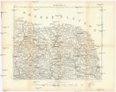
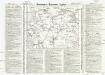
Mapa okresního hejtmanství Broumovského

Mapa okresního hejtmanství Broumovského

Karte der Bezirkshauptmannschaft Braunau
1 : 100000 Broumov-oblast (Náchod, Česko) Erben, Josef Karl Janský
Trautenau und Politz
1 : 75000 Broumov (Náchod, Česko : oblast) Fenzl K. u. k. Militärgeographisches Institut
Trautenau und Politz
1 : 75000 Police nad Metují (Česko : oblast) K. u. k. Militärgeographisches Institut
Karte der Bezirkshauptmannschaft Braunau
1 : 75000 Broumov-oblast (Náchod, Česko) Stelzig, Heinrich Heinrich Stelzig
Trutnov
1 : 75000 Trutnov (Česko : oblast) Vojenský zeměpisný ústav
Trutnov
1 : 75000 Trutnov-oblast (Česko) Vojenský zeměpisný ústav
Trutnov
1 : 75000 Trutnov (Česko : oblast) Vojenský zeměpisný ústav
[Kartenblatt]
1 : 25000 Adršpach (Česko : oblast) Reichsamt für Landesaufnahme
[Kartenblatt]
1 : 25000 Adršpach (Česko : oblast) Reichsamt für Landesaufnahme

Broumov-Úpice
1 : 74000 Broumov (Náchod, Česko : oblast) Weber-Ostwalden
Geologická mapa žacléřsko-svatoňovicko-žďáreckého uhelného revíru
1 : 75000 Žacléř-oblast (Česko) Sandtner, Boh. Hornicko-hutnické nakladatelství Prometheus

[Kartenblatt]
1 : 25000 Broumov (Náchod, Česko : oblast) Reichsamt für Landesaufnahme
[Gradkartenblatt]
1 : 25000 Broumov-oblast (Náchod, Česko) Vojenský zeměpisný ústav
III. vojenské mapování 3756/4
1 : 25000
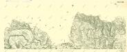
Meßtischblatt 5364 : Wüstegiersdorf, 1937
1 : 250000 Wüstegiersdorf. - Aufn. 1930, hrsg. 1934, einz. Nachtr. 1937. - 1:25000. - [Berlin]: Reichsamt für Landesaufnahme, 1937. - 1 Kt.
Meßtischblatt 3131 : Schömberg, 1936
1 : 250000 Schömberg. - Hrsg. 1886, bericht. 1925, gedr. [19]36. - 1:25000. - [Berlin]: Reichsamt für Landesaufnahme, 1936. - 1 Kt.
Meßtischblatt 3132 : Friedland in Schlesien, 1936
1 : 250000 Friedland in Schlesien. - Hrsg. 1884, bericht. 1925, gedr. [19]36. - 1:25000. - [Berlin]: Reichsamt für Landesaufnahme, 1936. - 1 Kt.
Meßtischblatt 3132 : Friedland in Schlesien, 1913
1 : 250000 Friedland in Schlesien. - Aufn. 1894, hrsg. 1896, Aufl.-dr. 1913. - 1:25000. - [Berlin]: Reichsamt für Landesaufnahme, 1913. - 1 Kt.
Meßtischblatt 3132 : Friedland (Bei Waldenburg), 1896
1 : 250000 Friedland (Bei Waldenburg). - Aufn. 1894. - 1:25000. - [Berlin]: Kgl. Preuss. Landesaufnahme, 1896. - 1 Kt.
[Kartenblatt]
1 : 25000 Broumov (Náchod, Česko : oblast) Reichsamt für Landesaufnahme