Maps of powiat kłodzki
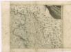
Special Karte der Grafschaft Glatz nebst angrenzenden Theilen von Böhmen und Mähren etc
1 : 150000 Kladsko-oblast (Polsko) Liebenow, W. Eduard Trewendt
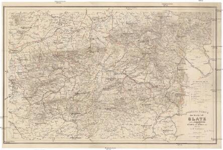
Karte der Umgegend von Gräfenberg
1 : 110000 Lázně Jeseník (Česko) Hennings, Th. Th. Hennings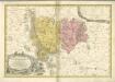

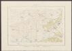
Sbírka map a diagramů použitých na mírových konferencích v Paříži v letech 1919 - 1920
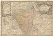
Principatvs Silesiae Grotkani exactissima tabula geographica exhibens terram Nissensem simul ac circulos Grotkau, Ottmuchau, et Ziegenhals
1 : 154000 Gródkow (Polsko) Wieland, Johann Wolfgang Schubarth, Matthäus ab Haeredibus Homannianis
Principatvs Silesiae Grotkani exactissima tabula geographica exhibens terram Nissensem simul ac circulos Grotkau Ottmuchau, et Ziegenhals
1 : 154000 Gródkow (Polsko) Wieland, Johann Wolfgang Schubarth, Matthäus Homannianos Heredes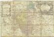
Principatvs Silesiae Grotkani exactissima tabula geographica exhibens terram Nissensem simul ac circulos Grotkau Ottmuchau, et Ziegenhals
1 : 154000 Gródkow (Polsko) Wieland, Johann Wolfgang Schubarth, Matthäus Haeredibus Homannianis
Comitatus Glatz [Karte], in: Novus atlas absolutissimus, Bd. 2, S. 247.
1 Karte aus Atlas Janssonius Offizin
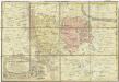
Comitatus Glaciensis
Comitatus Glatz [Karte], in: Theatrum orbis terrarum, sive, Atlas novus, Bd. 1, S. 150.
1 Karte aus Atlas Blaeu, Joan Blaeu, Willem Janszoon
Comitatus Glatz [Karte], in: Novus Atlas, das ist, Weltbeschreibung, Bd. 1, S. 185.
1 Karte aus Atlas Blaeu, Joan Blaeu, Willem Janszoon
Ducatus Silesiae Grotganus cum Districtu Episcopali Nissensi [Karte], in: Novus atlas absolutissimus, Bd. 2, S. 270.
1 Karte aus Atlas Janssonius Offizin
DVCATVS SILESIÆ | GROTGANVS | cum Districtu Episcopali | NISSENSI
Amstelædami J. Blaeu excudit
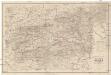
145. Glatz, uit: Topographische Uebersichtskarte des Deutschen Reiches / herausgegeben v. d. Kartogr. Abt. d. Königl. Preuß. Landesaufnahme
1 : 200000 titelvariant: Topogr. Übersichtskarte des Deutschen Reiches; Annotatie: Titel boven bladen ook: Topogr. Übersichtskarte des Deutschen Reiches; Annotatie geografische gegevens: Op elk blad twee maatstokken: 10 Kilometer = 5,5 cm; 1 geogr. Meile = 3,6 cm; Legenda onder op elk blad Königlich Preußische Landesaufnahme. Kartographische Abtheilung [S.l : Königlich Preußische Landesaufnahme, Kartographische Abtheilung]
Comitatus Glacensis
Kladsko-oblast (Polsko) Glocksperger, Johannes per Johannem Glocksperger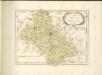

Comitatus Glatz [Karte], in: Le théâtre du monde, ou, Nouvel atlas contenant les chartes et descriptions de tous les païs de la terre, Bd. 1, S. 216.
1 Karte aus Atlas Blaeu, Willem Janszoon und Blaeu, Joan Blaeu, Willem Janszoon
[Glatz]
Kladsko-oblast (Polsko) Kreibich, František Jakub Jindřich
Comitatus Glaciensis tabula geogr
1 : 160000 Kladsko-oblast (Polsko) Mayer, Tobias edentibus Homannianis Heredibus
Comitatus Glaciensis tabula geogr
1 : 150000 Kladsko-oblast (Polsko) Mayer, Tobias Homannianos Heredes
Comitatus Glaciensis tabula geogr
1 : 160000 Kladsko-oblast (Polsko) Mayer, Tobias edentibus Homannianis Heredibus
Carte von der Grafschaft Glatz, und dem glücklichen Unternehmen der k. k. Truppen auf Habelschwerd und das Blockhaus zu Oberschwedeldorf, unter dem Kommando des tapfern Hr. Hr. Generalfeldmarschallieut. Grafen v. Wurmser den 18 Jaener 1779
1 : 137000 Kladsko-oblast (Polsko)
Kladsko
1 : 200000 Kladsko-oblast (Polsko) Service cartogr. de l ́Armee Tcheco-Sl.


COMITATVS | GLATZ
Authore Jona Sculteto. [Amsterdam : Joan Blaeu]
Sbírka map a diagramů použitých na mírových konferencích v Paříži v letech 1919 - 1920
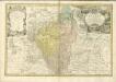
Principatvs Silesiae Mvnsterbergensis exactissima tabula geographica exhibens circulos ejusdem Mvnsterberg et Frankenstein una cum adjacentibus civitatibus Reichenstein et Silberberg ad principatum bregensem alias pertinentibus
1 : 100000 Slezsko Wieland, Johann Wolfgang Schubarth, Matthäus Homannianos Heredes