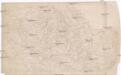
Maps of powiat kłodzki

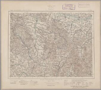
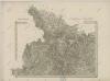
145. Glatz, uit: Topographische Uebersichtskarte des Deutschen Reiches / herausgegeben v. d. Kartogr. Abt. d. Königl. Preuß. Landesaufnahme
1 : 200000 titelvariant: Topogr. Übersichtskarte des Deutschen Reiches; Annotatie: Titel boven bladen ook: Topogr. Übersichtskarte des Deutschen Reiches; Annotatie geografische gegevens: Op elk blad twee maatstokken: 10 Kilometer = 5,5 cm; 1 geogr. Meile = 3,6 cm; Legenda onder op elk blad Königlich Preußische Landesaufnahme. Kartographische Abtheilung [S.l : Königlich Preußische Landesaufnahme, Kartographische Abtheilung]
Blatt I, uit: Geologisch-hydrographische Beschreibung des Niederschlagsgebietes der Glatzer-Neisse (oberhalb der Steinemündung) / A. Leppla ; hrsg. von der Königl. Preussischen geologischen Landesanstalt u. Bergakademie
Annotatie: Omslagtitel Königl. Preussische geologische Landesanstalt u. Bergakademie Berlin : Schropp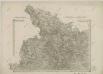
II. vojenské mapování 1
1 : 144000
Comitatus Glacensis
Kladsko-oblast (Polsko) Glocksperger, Johannes per Johannem Glocksperger
Special - Karte der Markgrafschaft Maehren und des Herzogthums Schlesien
II. vojenské mapování 1
1 : 144000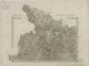
II. vojenské mapování 1
1 : 144000
II. vojenské mapování - speciální mapa Markrabství moravského s částí Slezského vévodství 1
1 : 144000
Jeseníky

Blatt VII, uit: Geologisch-hydrographische Beschreibung des Niederschlagsgebietes der Glatzer-Neisse (oberhalb der Steinemündung) / A. Leppla ; hrsg. von der Königl. Preussischen geologischen Landesanstalt u. Bergakademie
Annotatie: Omslagtitel Königl. Preussische geologische Landesanstalt u. Bergakademie Berlin : Schropp
Umgebungen von Friedberg und Freywaldau
Jeseník-oblast (Česko)
Umgebungen von Friedberg und Freywaldau
1 : 144000 K.K. Militärisches Geographisches Institut
Podrobná mapa Markrabství moravského a Vévodství slezkého
1 : 100000 Králíky (Ústí nad Orlicí, Česko : oblast) Srp, Jan Jos. R. Vilímek
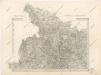
Die Grafschaft Glatz
1 : 460000 Kladsko (Polsko : oblast) Schreiber, Johann Georg J.G. Schreibern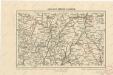
Kralický sněžník a Jeseníky

Jauernig und Weidenau.
from Spezialkarte der osterreichisch-ungarischen Monarchie.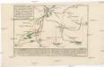
Plan des Angriffs, welcher unter dem ober Comando des kays. könig. Herrn Feldmarschall Lieutenants Grafen v. Wurmser, auf Habelschwerd, u. dem Blokhaus zu Oberschwedeldorffen in der Grafschafft Glaz den 18 Ien[n]er 1779 glücklich vollzogen worden
Kladská Bystřice (Polsko) Marinville, de Will, Johann Martin Ioh. Martin Will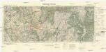
Mittelwalde-Kamnitz
1 : 100000 Międzylesie (Polsko : oblast) Reichsamt für Landesaufnahme-Reichskartenstelle
Javorník a Ottmachau
1 : 75000 Javorník (Jeseník, Česko : oblast) Vojenský zeměpisný ústav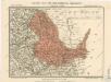
Generální mapa okresních hejtmanství

Žamberk
1 : 75000 Žamberk (Česko : oblast) Vojenský zeměpisný ústav
Žamberk
1 : 75000 Žamberk (Česko : oblast) Vojenský zeměpisný ústav
Freiwaldau
1 : 75000 Jeseník (Česko : oblast) Richter K. u. k. Militärgeographisches Institut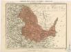
Generální mapa okresních hejtmanství

III. vojenské mapování 3857
1 : 75000
Kunštát a Glatz
1 : 75000 Kladsko (Polsko : oblast) Vojenský zeměpisný ústav
Jeseníky
[Reichenau und Umgebung]
1 : 144000 Rychnov nad Kněžnou-oblast (Česko) Kořistka, Karel František Edvard