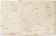
Maps of okres Jeseník

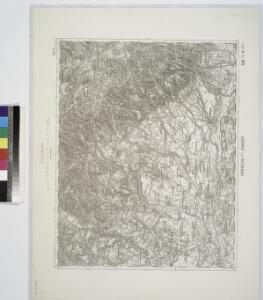
Jauernig und Weidenau.
from Spezialkarte der osterreichisch-ungarischen Monarchie.
Javorník a Ottmachau
1 : 75000 Javorník (Jeseník, Česko : oblast) Vojenský zeměpisný ústav
III. vojenské mapování 3858
1 : 75000
III. vojenské mapování 3858
1 : 75000
Javorník a Ottmachau
1 : 75000 Javorník (Jeseník, Česko : oblast) Vojenský zeměpisný ústav
Javorník
1 : 75000 Javorník (Jeseník, Česko) Vojenský zeměpisný ústav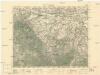
Javorník
1 : 75000 Javorník (Jeseník, Česko : oblast) Vojenský zeměpisný ústav
Cukmantl a Neustadt i. O. Schles
1 : 75000 Polsko Vojenský zeměpisný ústav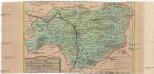
Special-Carte des Fürstenthums Grotkau oder Neisse, in Ober-Schlesien, an den böhmischen und mährische[n] Grentzen
1 : 300000 Grodków-oblast (Polsko) Wieland, Johann Wolfgang Schleuen, Johann David I.D. Schleuen


Podrobná mapa Markrabství moravského a Vévodství slezkého
1 : 100000 Javorník (Jeseník, Česko : oblast) Srp, Jan Jos. R. Vilímek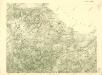
III. vojenské mapování 3858/4
1 : 25000
[Kartenblatt]
1 : 25000 Lądek Zdrój (Polsko) Reichsamt für Landesaufnahme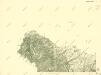
III. vojenské mapování 3858/1
1 : 25000

III. vojenské mapování 3858/4
1 : 25000
[Kartenblatt]
1 : 25000 Javorník (Jeseník, Česko : oblast) Reichsamt für Landesaufnahme
[Kartenblatt]
1 : 25000 Jeseníky (Česko : pohoří) Reichsamt für Landesaufnahme
[Kartenblatt]
1 : 25000 Bernartice (Jeseník, Česko) Reichsamt für Landesaufnahme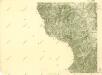
III. vojenské mapování 3858/3
1 : 25000
III. vojenské mapování 3858/1
1 : 25000

III. vojenské mapování 3858/3
1 : 25000
Gradabtheilung 51/50 der Breite 34/35 der Länge
Kořistka, Karel František Edvard
Meßtischblatt 3343 : Bielendorf, 1936
1 : 250000 Bielendorf. - Hrsg. 1883, Nachtr. 1912, gedr. [19]36. - 1:25000. - [Berlin]: Reichsamt für Landesaufnahme, 1936. - 1 Kt.
Meßtischblatt 3342 : Wilhelmsthal, 1912
1 : 250000 Wilhelmsthal. - Hrsg. 1883, Nachtr. 1912. - 1:25000. - [Berlin]: Preuss. Landesaufnahme, 1912. - 1 Kt.
Meßtischblatt 5668 : Ober Hermsdorf, 1936
1 : 250000 Ober Hermsdorf. - Hrsg. 1883, kl. Nachtr. 1913. - 1:25000. - [Berlin]: Reichsamt für Landesaufnahme, 1936. - 1 Kt.