Maps of gmina Stronie Śląskie

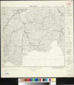
Meßtischblatt 3342 : Wilhelmsthal, 1912
1 : 250000 Wilhelmsthal. - Hrsg. 1883, Nachtr. 1912. - 1:25000. - [Berlin]: Preuss. Landesaufnahme, 1912. - 1 Kt.
Gradabtheilung 51/50 der Breite 34/35 der Länge
Kořistka, Karel František Edvard
Kunzendorf (Kunczicze) - m1423-1-001 - Kaiserpflichtexemplar der Landkarten des stabilen Katasters
1 : 2880
Kunzendorf (Kunczicze) - m1423-1-010 - Kaiserpflichtexemplar der Landkarten des stabilen Katasters
1 : 2880
Kunzendorf (Kunczicze) - m1423-1-006 - Kaiserpflichtexemplar der Landkarten des stabilen Katasters
1 : 2880
Kunzendorf (Kunczicze) - m1423-1-008 - Kaiserpflichtexemplar der Landkarten des stabilen Katasters
1 : 2880
Kunzendorf (Kunczicze) - m1423-1-011 - Kaiserpflichtexemplar der Landkarten des stabilen Katasters
1 : 2880
Kunzendorf (Kunczicze) - m1423-1-007 - Kaiserpflichtexemplar der Landkarten des stabilen Katasters
1 : 2880
Kunzendorf (Kunczicze) - m1423-1-002 - Kaiserpflichtexemplar der Landkarten des stabilen Katasters
1 : 2880
Kunzendorf (Kunczicze) - m1423-1-004 - Kaiserpflichtexemplar der Landkarten des stabilen Katasters
1 : 2880
Kunzendorf (Kunczicze) - m1423-1-005 - Kaiserpflichtexemplar der Landkarten des stabilen Katasters
1 : 2880
Kunzendorf (Kunczicze) - m1423-1-003 - Kaiserpflichtexemplar der Landkarten des stabilen Katasters
1 : 2880
Kunzendorf (Kunczicze) - m1423-1-009 - Kaiserpflichtexemplar der Landkarten des stabilen Katasters
1 : 2880
Spiglitz - m2023-2-003 - Kaiserpflichtexemplar der Landkarten des stabilen Katasters
1 : 2880
Spiglitz - m2023-2-004 - Kaiserpflichtexemplar der Landkarten des stabilen Katasters
1 : 2880
Spiglitz - m2023-2-006 - Kaiserpflichtexemplar der Landkarten des stabilen Katasters
1 : 2880
Spiglitz - m2023-2-001 - Kaiserpflichtexemplar der Landkarten des stabilen Katasters
1 : 2880
Spiglitz - m2023-2-002 - Kaiserpflichtexemplar der Landkarten des stabilen Katasters
1 : 2880
Spiglitz - m2023-2-005 - Kaiserpflichtexemplar der Landkarten des stabilen Katasters
1 : 2880
[Kartenblatt]
1 : 25000 Králický Sněžník (Česko a Polsko : pohoří) Reichsamt für Landesaufnahme
III. vojenské mapování 3958/1
1 : 25000
III. vojenské mapování 3958/1
1 : 25000

Jauernig und Weidenau.
from Spezialkarte der osterreichisch-ungarischen Monarchie.

Freiwaldau
1 : 75000 Jeseník (Česko : oblast) Richter K. u. k. Militärgeographisches Institut
Javorník a Ottmachau
1 : 75000 Javorník (Jeseník, Česko : oblast) Vojenský zeměpisný ústav
[Kartenblatt]
1 : 25000 Lądek Zdrój (Polsko) Reichsamt für Landesaufnahme
Podrobná mapa Markrabství moravského a Vévodství slezkého
1 : 100000 Javorník (Jeseník, Česko : oblast) Srp, Jan Jos. R. Vilímek