Maps of powiat świdnicki

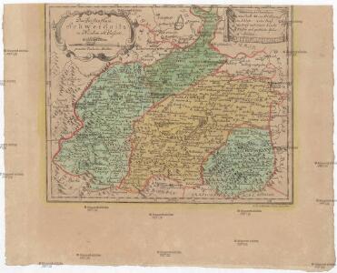
Das Fürstenthum Schweidnitz in Nieder-Schlesien
1 : 290000 Svídnice-oblast (Polsko) Wieland, Johann Wolfgang Schleuen, Johann David I.D. Schleuen
Dvcatvs Silesiae Schwidnicensis
1 : 172500 Mollova mapová sbírka Kuhn, Friedrich Schenk, Peter I
Principatvs Silesiae Schwidnicensis Secundum ejusdem Circvlos Schweidnitz, Striegav, Bolckenhain, Landeshut & Reichenbach divisi et Geometr.
1 : 125000 Mollova mapová sbírka Wieland, Johann Wolfgang Homann, Johann Baptista - dědici
Das Fürstenthum Schweidnitz in Nieder Schlesien
1 : 300000 Mollova mapová sbírka Schleuen, Johann David Schleuen, Johann David
Das Fürstenthum Schweidnitz
1 : 130000 Slezsko Sotzmann, Daniel Friedrich Fembo, Christoph Christoph Fembo
Müllerova mapa Čech V
1 : 132000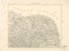
Podrobná místopisná mapa Království Českého

Plaan der merkwrüdigen Stellung drey grossen Armeen
1 : 100000 Svídnice-oblast (Polsko) Mayer
Geologische Übersichtskarte des Zobtengebietes
1 : 100000 Finckh, Ludwig. Preuß. Geol. Landesanstalt

Entwurff der bey Landshut in Schlesien den 13.ten u. 14.ten Augusti Ao 1757 vorgefallen Action unter Com[m]ando des Herrn Obristen Baron von Jahnus
Slezsko (Polsko) Salzer, Ignác
Conradvs Ernest Maximilianvs S.R.I. Comes de Hochberg Liber Baro in et de Fürstenstein Dynasta Dynastiarvm Fürstenstein et Friedland
Mollova mapová sbírka Spanninger, J. G. V. Tscherning, Jan
[Kartenblatt]
1 : 25000 Adršpach (Česko : oblast) Reichsamt für Landesaufnahme
[Kartenblatt]
1 : 25000 Adršpach (Česko : oblast) Reichsamt für Landesaufnahme
[Schweidnitz und Umgebung]
1 : 100000 Svídnice (Polsko : oblast)
Meßtischblatt 3075 : Reichenbach, Eulengebirge, 1932
1 : 250000 Reichenbach, Eulengebirge. - Hrsg. 1883, bericht. 1926, einz. Nachtr. 1932. - 1:25000. - [Berlin]: Reichsamt für Landesaufnahme, 1932. - 1 Kt.
Meßtischblatt 3074, neue Nr. 5264 : Bad Charlottenbrunn, 1939
1 : 250000 Bad Charlottenbrunn. - Aufn. 1881, hrsg. 1883, bericht. 1937, redakt. Änd. [19]38. - 1:25000. - [Berlin]: Reichsamt für Landesaufnahme, 1939. - 1 Kt.
Meßtischblatt 5262 : Landeshut, 1939
1 : 250000 Landeshut. - Aufn. 1884, hrsg. 1886, bericht. 1936/37. - 1:25000. - [Berlin]: Reichsamt für Landesaufnahme, 1939. - 1 Kt.
Meßtischblatt 3072 : Landeshut, 1930
1 : 250000 Landeshut. - Hrsg. 1886, bericht. 1925, einz. Nachtr. 1930. - 1:25000. - [Berlin]: Reichsamt für Landesaufnahme, 1930. - 1 Kt.
Meßtischblatt 5266 : Lauterbach, Schlesien, 1938
1 : 250000 Lauterbach, Schlesien. - Aufn. 1881, hrsg. 1883, bericht. 1926/37/38, letzte Nachtr. 1932, Ausg. 1938. - 1:25000. - [Berlin]: Reichsamt für Landesaufnahme, 1938. - 1 Kt.
Meßtischblatt 3073 : Waldenburg in Niederschlesien, 1934
1 : 250000 Waldenburg in Niederschlesien. - Hrsg. 1884, bericht. 1925, einz. Nachtr. 1930, gedr. [19]34. - 1:25000. - [Berlin]: Reichsamt für Landesaufnahme, 1934. - 1 Kt.
Meßtischblatt 3073 : Waldenburg in Niederschlesien, 1907
1 : 250000 Waldenburg in Niederschlesien. - Aufn. 1884, hrsg. 1886, bericht. 1907. - 1:25000. - [Berlin]: Kgl. Preuss. Landesaufnahme, 1907. - 1 Kt.
Meßtischblatt 3012 : Freiburg in Schlesien, 1907
1 : 250000 Freiburg in Schlesien. - Aufn. 1884, hrsg. 1886, bericht. 1907. - 1:25000. - [Berlin]: Kgl. Preuss. Landesaufnahme, 1907. - 1 Kt.
Meßtischblatt 3014 : Weizenrodau, 1932
1 : 250000 Weizenrodau. - Hrsg. 1881, bericht. 1925, einz. Nachtr. 1932. - 1:25000. - [Berlin]: Reichsamt für Landesaufnahme, 1932. - 1 Kt.
Meßtischblatt 3013 : Schweidnitz, 1932
1 : 250000 Schweidnitz. - Hrsg. 1883, bericht. 1925, einz. Nachtr. 1932. - 1:25000. - [Berlin]: Reichsamt für Landesaufnahme, 1932. - 1 Kt.
Meßtischblatt 3011 : Ruhbank, 1936
1 : 250000 Ruhbank. - Hrsg. 1886, bericht. 1936. - 1:25000. - [Berlin]: Reichsamt für Landesaufnahme, 1936. - 1 Kt.
Meßtischblatt 3011 : Ruhbank, 1933
1 : 250000 Ruhbank. - Hrsg. 1886, bericht. 1925, gedr. [19]33. - 1:25000. - [Berlin]: Reichsamt für Landesaufnahme, 1933. - 1 Kt.
Meßtischblatt 3015 : Zobten, 1883
1 : 250000 Zobten. - Aufn. 1881, hrsg. 1883, einz. Nachtr. 1883. - 1:25000. - [Berlin]: Kgl. Preuss. Landesaufnahme, 1883. - 1 Kt.
Meßtischblatt 3012 : Freiburg in Niederschlesien, 1934
1 : 250000 Freiburg in Niederschlesien. - Hrsg. 1886, bericht. 1925, einz. Nachtr. 1930, gedr. [19]34. - 1:25000. - [Berlin]: Reichsamt für Landesaufnahme, 1934. - 1 Kt.