Maps of Bayern
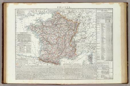
Francia.
1 : 3000000 Marzolla, Benedetto
Le Cours du Danube
1 : 1800000 Mollova mapová sbírka Placide de Sainte-Hélène Inselin, Charles
Carte itinéraire indiquant la marche des armées Françaises en Allemagne et en Italie : faisant suite à la carte en 8 feuilles de L. Capitaine ... / par P.C. Chanlaire
1 : 850000 Annotatie: Overige bl. niet aanwezig Chanlaire, P. C Paris : Dépot de Géographie
Germany (Deutschland)
1 : 1750000 Bavorsko (Německo) Baldwin & Cradock
Suisse
1 : 3500000 1 Karte [Alain Manesson Mallet] [in verlegung Johann David Zunners], [Franckfurt am Mayn]
<<Les>> 13 cantons suisses et leurs alliéz
1 : 3500000 1 Karte [Alain Manesson Mallet] [chez Denys Thierry?], [Paris]
<<La>> Suisse
1 : 5000000 1 Karte [von S.L. Hegrad] [bey Sebastian Hartl in der Singerstrasse], [Wien]
Germany. Deutschland III.
1 : 1760000 Society for the Diffusion of Useful Knowledge (Great Britain)
<<[Die>> Schweitz]
1 : 4000000 1 Karte [Johann Ulrich Müller] [Andrea], [Frankfurt a. M.]
German Empire 3.
1 : 1774080 Letts, Son & Co.
Raetiae veteris exterae et hodiernae una cum regionibus ei guondam [i.e. quondam] adnumeratis & finitimarum regionum limitibus tabula generalis
1 : 1100000 1 Karte Matth. Hirtzg. ; Leo. Scherer [Joh. Rodolff Wolffen], [Zürich]
Karte von Deutschland in IV Blättern
1 : 825000 Südwest-Blatt Sotzmann, Daniel Friedrich im Verlage der A. G. Schneider und Weigels
Carte de Suisse suivant sa nouvelle division en XVIII cantons formant la république helvétique
1 Karte in 2 Teilen auf 1 Bl. dressée par H. Mallet ; Emery sc. [chez F. Monty], [Genève]
Totivs Sveviæ novissima tabvla
1 Karte : Kupferdruck ; 37 x 47 cm Janssonius ex officina Ioannis Ianssonii
Svevia
1 Karte : Kupferdruck ; 26 x 34 cm Merian Merian
Souabe, Baviere.
1 : 2900000 Clouet, J. B. L. (Jean-Baptiste Louis), b. 1730
Le royaume de France, 6
1 Blatt : 48 x 46 cm Jaillot
Circvli Avstriaci Pars alterior comprehendens Comit. Tirolensem et Territoria Suevica
1 : 2600000 Mollova mapová sbírka Franz, Johann Michael Homann, Johann Baptista - dědici
Das Königreich Baiern
Allgemeiner Atlas [Walch, Johannes] im Verlag bei Johannes Walch
Neueste Karte von Bayern, Tirol mit dem grösten Theil von Schwaben und angränzenden österreichischen Provinzen
1 : 790000 Bavorsko (Německo) Sotzmann, Daniel Friedrich Artaria
Italie Septentrionale.
1 : 1500000 Clouet, J. B. L. (Jean-Baptiste Louis), b. 1730
Vindelicien Rhetien und Noricvm
Noricum Baumgarten, Siegmund Jakob Johann Justinus Gebauer
Padi Fluvii Tractvs integer
1 : 2000000 Mollova mapová sbírka
Societas Iesu Provinciae Germaniae Superioris in sua Collegia distributae
Mollova mapová sbírka Herz, Johann Daniel Herz, Johann Daniel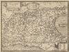
Italia Gallica, Sive Gallia Cisalpina. [Karte], in: Theatrum orbis terrarum, S. 490.
1 Karte aus Atlas Ortelius, Abraham Vrients, Jan Baptista
Die Staaten von Ober Italien
Itálie severní Stanich, Eugen Rothenburg, R. von Verlag der geographischen Anstalt des Bibliographischen Instituts
De Stoel des Oorlogs in Italien
1 : 750000 Mollova mapová sbírka Visscher, Nicolaes Anse, Luggert van Schenk, Peter II
The south west part of Germany.
1 : 2400000 Moll, Herman, d. 1732
[Italien, Blatt 1]
Adolf Stieler's Handatlas über alle Theile der Erde und über das Weltgebäude Stieler, Adolf Justus Perthes