Maps of Tuscany

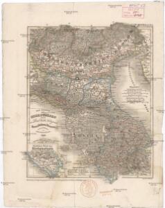
Die Staaten von Ober Italien
Itálie severní Stanich, Eugen Rothenburg, R. von Verlag der geographischen Anstalt des Bibliographischen Instituts
Le royaume de France, 6
1 Blatt : 48 x 46 cm Jaillot
Tableau l'historie des Duches de Toscane, Parma, Modene, Lucques, et du Royme. Lombard-Venetien.
1 : 3100000 Duval, Henri
Die Staaten von Oberitalien

Carte itinéraire indiquant la marche des armées Françaises en Allemagne et en Italie : faisant suite à la carte en 8 feuilles de L. Capitaine ... / par P.C. Chanlaire
1 : 850000 Annotatie: Overige bl. niet aanwezig Chanlaire, P. C Paris : Dépot de Géographie
Italien 1.
1 : 1800000 Flemming, Carl
Italy. North Part.
1 : 2500000 Mitchell, Samuel Augustus
Italien
1 : 2500000 Itálie severní Bibliographisches Institut
Flemming's neueste Karte des Kriegsschauplatzes in Italien
1 : 618000 Itálie severní C. Flemming
Uibersichts-Carte der Staaten Toscana, Modena u. Parma mit ihrer neuen Gränzbestim[m]ung
Modena (Itálie)
Italy middle, upper.
1 : 1100000 Robert Laurie & James Whittle
Northern Italy.
1 : 3168000 Tallis, J. & F.
Italy. North Part.
1 : 2450000 Tanner, Henry S.
Italy North Part.
1 : 2450000 Tanner, Henry S.
Nördliches Jtalien
Stieler's Hand-Atlas Stieler, Adolf bei Justus Perthes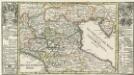
Die Niedere oder Oostliche Lombardia.
1 : 2900000 Mollova mapová sbírka Bodenehr, Gabriel Bodenehr, Gabriel
Composite XI, XII, XVI, XVII: Karte Des Oesterreichischen Kaiserstaates.
1 : 576000 Scheda, Josef
Specielle Reise-Karte vom Bayerischen Hochland, Nord-Tyrol, Salzburg, und Salzkammergut : mit einer Vergleichenden Höhendarstellung nach den neuesten amtlichen Vermessungen
1 : 500000 Mayr, [Johann] Georg Mayr
Italien. Nördliche Hälfte

76-77. Italy, North. The World Atlas.
1 : 1250000 USSR (Union of Soviet Socialist Republics).
N. Italy, Alps, Apennines.
1 : 1250000 Arrowsmith, John
Delineatio Regni Italici seu potius reliquiarum Regni Longobardici, quae hodie Longobardia seu Italis Lombardia dicuntur, finibus Franciae, Helvetiae, Germaniae, Dom. Veneti et St. Ecclesiae accurate distinctis
1 : 4600000 Mollova mapová sbírka Franz, Johann Michael Homann, Johann Baptista - dědici
Florenz
1 : 1500000 Itálie severní K. u. k. Militärgeograph. Institute
Northern Italy.
1 : 1090000 Pinkerton, John, 1758-1826
The upper part of Italy.
1 : 2700000 Moll, Herman, d. 1732
Italy, North Part.
1 : 2500000 Tanner, Henry S.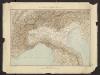
Géographie. croquis n1, Italie continentale
1 : 1000000 Messain, Capitaine 18..-.... [Paris] : Service Géographique de l'Armée
Northern Italy.
1 : 1270000 Mitchell, Samuel Augustus