Maps of Switzerland

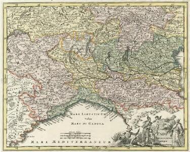
Padi Fluvii Tractvs integer
1 : 2000000 Mollova mapová sbírka
<<[Die>> Schweitz]
1 : 4000000 1 Karte [Johann Ulrich Müller] [Andrea], [Frankfurt a. M.]
Les montagnes des Alpes ou sont remarqués les passages de France en Italie, le Duché de Milan, et les estats du duc de Savoye &c. / dressé sur les memoires les plus nouveaux par le Sr. Sanson ...
1 : 600000 Annotatie: Titel boven de kaart: Les montagnes des Alpes, ou sont remarqués les passages de France en Italie, le Duché de Milan, et les estats du duc de Savoye qui cõpreñent le Duché de Savoye et la Principauté de Piemont, &c; Avec privilège du Roy, pour 20 ans, 1676; Origineel is Blad 152 in atlas factice; Annotatie geografische gegevens: Met 6 schaalstokken A Paris : chez H. Iaillot
<<La>> Suisse
1 : 5000000 1 Karte [von S.L. Hegrad] [bey Sebastian Hartl in der Singerstrasse], [Wien]
Le Cours du Danube
1 : 1800000 Mollova mapová sbírka Placide de Sainte-Hélène Inselin, Charles
Schweizerische Eidsgenossenschaft
1 : 1250000 1 Karte [Verlag nicht ermittelbar], [St. Gallen]
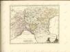
Carte dell'Italia superiore e di parte degli stati limitrofi
1 : 1000000 Itálie severní Bacler Dalbe, Louis Albert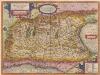
Italia Gallica, Sive Gallia Cisalpina. [Karte], in: Theatrum orbis terrarum, S. 389.
1 Karte aus Atlas Ortelius, Abraham
Fo. 1, uit: Carta geologica d'Italia
1 : 1000000 Rome : R. Ufficio Geologico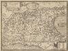
Italia Gallica, Sive Gallia Cisalpina. [Karte], in: Theatrum orbis terrarum, S. 490.
1 Karte aus Atlas Ortelius, Abraham Vrients, Jan Baptista
Postkarte von Ober Italien
Itálie severní Stenger, Johann im von Reillyschen Landkarten und Kunstwerke Verschleiss Komptoir
Karte von Ober-Italien
1 : 900000 Leuzinger, Rudolf J. Wurster & Cie.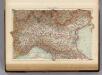
Italy North.
1 : 1500000 Andree, Richard; Times (London, England)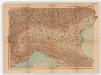
Norditalien. Sonderkarte 3
1 : 1000000 Geographische Anstalt von Velhagen & Klasing (Lipsko) Leipzig : Velhagen & Klasing
Geognostische Karte der Alpen in Savoyen und der Schweitz in einem Theile von Deutschland, Frankreich, Piemont und der Lombardei
1 : 1300000 1 Karte gez. von F. Schoedinger ; gest. von J. Scheurman [Orell, Füssli und Compagnie], [Zürich]
Geognostische Karte der Alpen in Savoyen und der Schweitz in einem Theile von Deutschland, Frankreich, Piemont und der Lombardei
1 : 1300000 1 Karte gez. von F. Schoedinger ; gest. von J. Scheurmann [Orell, Füssli und Compagnie?], [Zürich?]
Carta d'Italia alla scala di 1 a 1 000 000
1 : 1000000 Nordwest-Blatt Istituto Geografico Militare (Firenze) Istituto Geografico Militare
Carte de Suisse suivant sa nouvelle division en XVIII cantons formant la république helvétique
1 Karte in 2 Teilen auf 1 Bl. dressée par H. Mallet ; Emery sc. [chez F. Monty], [Genève]
Ancient Italy I.
1 : 1770000 Society for the Diffusion of Useful Knowledge (Great Britain)
Italy I.
1 : 1770000 Society for the Diffusion of Useful Knowledge (Great Britain)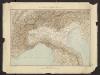
Géographie. croquis n1, Italie continentale
1 : 1000000 Messain, Capitaine 18..-.... [Paris] : Service Géographique de l'Armée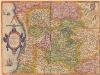
Ducatus Mediolanensis, Finitimarumque Regionum Descriptio [Karte], in: Theatrum orbis terrarum, S. 198.
1 Karte aus Atlas Ortelius, Abraham
N. parts of Italy.
1 : 2750000 Bowen, Emanuel
Geognostische Karte der Alpen in Savoyen und der Schweitz
1 : 1300000 1 Karte gez. von F. Schoedinger ; gest. von J. Scheurmann [Orell, Füssli und Compagnie?], [Zürich?]
Switzerland
1 : 850000 1 Karte engraved by George Philip & Son Philip & Son, Liverpool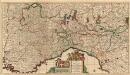
Sedes Belli in Italiâ
1 : 870000 Mollova mapová sbírka Danckerts, Justus Danckerts, Justus
Swisserland
1 : 770000 1 Karte [by John Thomson] ; T. Clerk sculpt. [Ramsay?], [Edinburgh]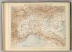
Carte Physique et Militaire des Alpes et du Po.
1 : 970000 Jouvet et Cie.