Maps of Alps

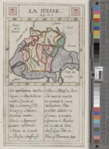
<<La>> Suisse
1 : 5000000 1 Karte [von S.L. Hegrad] [bey Sebastian Hartl in der Singerstrasse], [Wien]
<<A>> new & accurate map of Switzerland with its allies and subjects
1 : 1700000 1 Karte composed from ey. most approv'd maps &c and regulated by astronom. observat. by Emanl. Bowen [printed for William Innys ...], [London]
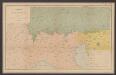
Geognostische Karte der Alpen in Savoyen und der Schweitz in einem Theile von Deutschland, Frankreich, Piemont und der Lombardei
1 : 1300000 1 Karte gez. von F. Schoedinger ; gest. von J. Scheurman [Orell, Füssli und Compagnie], [Zürich]
Geognostische Karte der Alpen in Savoyen und der Schweitz in einem Theile von Deutschland, Frankreich, Piemont und der Lombardei
1 : 1300000 1 Karte gez. von F. Schoedinger ; gest. von J. Scheurman [Orell, Füssli und Compagnie], [Zürich]
Geognostische Karte der Alpen in Savoyen und der Schweitz in einem Theile von Deutschland, Frankreich, Piemont und der Lombardei
1 : 1300000 1 Karte gez. von F. Schoedinger ; gest. von J. Scheurmann [Orell, Füssli und Compagnie?], [Zürich?]
Geognostische Karte der Alpen in Savoyen und der Schweitz in einem Theile von Deutschland, Frankreich, Piemont und der Lombardei
1 : 1300000 1 Karte gez. von F. Schoedinger ; gest. von J. Scheurman [Orell, Füssli und Compagnie], [Zürich]
Le Cours du Danube
1 : 1800000 Mollova mapová sbírka Placide de Sainte-Hélène Inselin, Charles
Carte de Suisse suivant sa nouvelle division en XVIII cantons formant la république helvétique
1 Karte in 2 Teilen auf 1 Bl. dressée par H. Mallet ; Emery sc. [chez F. Monty], [Genève]
Switzerland
1 : 850000 1 Karte engraved by George Philip & Son Philip & Son, Liverpool
[Helvetien]
1 : 3100000 1 Karte entworfen von F.L. Güssefeld ; gestochen von C. Westermayr [im Verlage des Industrie Comptoirs], [Weimar]
<<[Die>> Schweitz]
1 : 4000000 1 Karte [Johann Ulrich Müller] [Andrea], [Frankfurt a. M.]
Geologische Übersichtskarte der Alpen
1 : 1000000 Alpy (pohoří) Noe, Franz Suess, Eduard Ed. Hölzel's geographisches Institut
Helvetia
1 : 2500000 1 Karte [ed.: Alphons Lasor a Varea] [Verlag nicht ermittelbar], [Patavii]
Helvetia
1 : 2500000 1 Karte [ed.: Giovanni Antonio Magini] [Petrus Keschedt], [In celeberrima Agrippinensium Colonia]
Swisserland
1 : 770000 1 Karte [by John Thomson] ; T. Clerk sculpt. [Ramsay?], [Edinburgh]
<<Les>> 13 cantons suisses et leurs alliéz
1 : 3500000 1 Karte [Alain Manesson Mallet] [chez Denys Thierry?], [Paris]
[Helvetien]
1 : 3100000 1 Karte entworfen von F.L. Güssefeld ; gestochen von J.C. Müller [im Verlage des Industrie Comptoirs], [Weimar]
Ed. Hölzels große Handkarte der Grenzländer Österreich-Ungarn Italien
1 : 1000000 Itálie Hölzel, Eduard Ed. Hölzel
Geognostische Karte der Alpen in Savoyen und der Schweitz
1 : 1300000 1 Karte gez. von F. Schoedinger ; gest. von J. Scheurmann [Orell, Füssli und Compagnie?], [Zürich?]
Höhenschichtenkarte der Alpen
Sprachkarte der Alpen
1 : 2000000 Wäber, Adolf ; Leuzinger, Rudolf [Verlag der Expedition des Jahrbuches des S.A.C.]
General-Carte der Schweiz
1 : 1200000 1 Karte entworfen und gestochen von J. Scheurmann bey Orell Füssli & Compagnie, Zürich
Helvetiae descriptio
1 Karte Aegidio Tschudo auct. ; [Abraham Ortelius fecit] [en la emprenta de Roberto Bruneau?], [Anveres]
[Helvetia]
1 : 700000 1 Karte auf 2 Bl. Paulus de Forlanis [Forlani], Venetij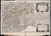
Les montagnes des Alpes ou sont remarqués les passages de France en Italie, le Duché de Milan, et les estats du duc de Savoye &c. / dressé sur les memoires les plus nouveaux par le Sr. Sanson ...
1 : 600000 Annotatie: Titel boven de kaart: Les montagnes des Alpes, ou sont remarqués les passages de France en Italie, le Duché de Milan, et les estats du duc de Savoye qui cõpreñent le Duché de Savoye et la Principauté de Piemont, &c; Avec privilège du Roy, pour 20 ans, 1676; Origineel is Blad 152 in atlas factice; Annotatie geografische gegevens: Met 6 schaalstokken A Paris : chez H. Iaillot
Helvetia
1 : 2500000 1 Karte [appresso P. & F. Galignani], [Padova]
Nova Rhaetiae atque totius Helvetiae descriptio
1 : 350000 1 Karte auf 10 Bl. per Aegidium Tschudum Glaronensem Hofer & Burger, Zürich
Schweizerische Eidsgenossenschaft
1 : 1250000 1 Karte [Verlag nicht ermittelbar], [St. Gallen]
<<Les>> Suisses, les alliés des Suisses et leurs sujets
1 Karte par N. Sanson d'Abbeville ; R. Cordier sculp. [Verlag nicht ermittelbar], [Erscheinungsort nicht ermittelbar]