Maps of Alps

Helvetiae descriptio
1 Karte Aegidio Tschudo auct. ; [Abraham Ortelius fecit] [en la emprenta de Roberto Bruneau?], [Anveres]
Carte de Suisse suivant sa nouvelle division en XVIII cantons formant la république helvétique
1 Karte in 2 Teilen auf 1 Bl. dressée par H. Mallet ; Emery sc. [chez F. Monty], [Genève]
[Helvetia]
1 : 700000 1 Karte auf 2 Bl. Paulus de Forlanis [Forlani], Venetij
<<A>> new & accurate map of Switzerland with its allies and subjects
1 : 1700000 1 Karte composed from ey. most approv'd maps &c and regulated by astronom. observat. by Emanl. Bowen [printed for William Innys ...], [London]
[Helvetien]
1 : 3100000 1 Karte entworfen von F.L. Güssefeld ; gestochen von J.C. Müller [im Verlage des Industrie Comptoirs], [Weimar]
[Helvetien]
1 : 3100000 1 Karte entworfen von F.L. Güssefeld ; gestochen von C. Westermayr [im Verlage des Industrie Comptoirs], [Weimar]
Helvetia
1 : 2500000 1 Karte [ed.: Giovanni Antonio Magini] [Petrus Keschedt], [In celeberrima Agrippinensium Colonia]
Geognostische Karte der Alpen in Savoyen und der Schweitz in einem Theile von Deutschland, Frankreich, Piemont und der Lombardei
1 : 1300000 1 Karte gez. von F. Schoedinger ; gest. von J. Scheurman [Orell, Füssli und Compagnie], [Zürich]
Geognostische Karte der Alpen in Savoyen und der Schweitz in einem Theile von Deutschland, Frankreich, Piemont und der Lombardei
1 : 1300000 1 Karte gez. von F. Schoedinger ; gest. von J. Scheurman [Orell, Füssli und Compagnie], [Zürich]
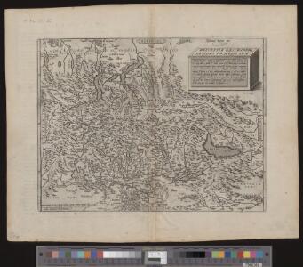
Nova Rhaetiae atque totius Helvetiae descriptio
1 : 350000 1 Karte auf 10 Bl. per Aegidium Tschudum Glaronensem Hofer & Burger, Zürich
<<Les>> 13 cantons suisses et leurs alliéz
1 : 3500000 1 Karte [Alain Manesson Mallet] [chez Denys Thierry?], [Paris]
Geognostische Karte der Alpen in Savoyen und der Schweitz in einem Theile von Deutschland, Frankreich, Piemont und der Lombardei
1 : 1300000 1 Karte gez. von F. Schoedinger ; gest. von J. Scheurmann [Orell, Füssli und Compagnie?], [Zürich?]
Geognostische Karte der Alpen in Savoyen und der Schweitz in einem Theile von Deutschland, Frankreich, Piemont und der Lombardei
1 : 1300000 1 Karte gez. von F. Schoedinger ; gest. von J. Scheurman [Orell, Füssli und Compagnie], [Zürich]
General-Carte der Schweiz
1 : 1200000 1 Karte entworfen und gestochen von J. Scheurmann bey Orell Füssli & Compagnie, Zürich
Switzerland
1 : 850000 1 Karte engraved by George Philip & Son Philip & Son, Liverpool
Helvetia
1 : 4200000 1 Karte Aegidio Tschudo auctore [de l'Imprimérie de Christofle Plantin], [Anvers]
<<La>> Suisse avec les distances en lieues
1 : 2000000 1 Karte bey Hrch. Keller, Zürich
Helvetia, Rhaetia, Valesia
1 : 580000 1 Karte labore et studio Henrici Ludovici Muoss bei dem Author, Zug
Erste Post- & Dampfschifffahrt Reise Carte der Schweiz
1 : 750000 1 Karte entworfen, bearb. und einer hochloblichen Post-Commission der Stadt Basel ergebenst gewidmet von Hiers. Rumpf ; auf Stein gestochen von C. Bruder E. Hindermann's Witwe, Basel
Helvetia
1 : 2500000 1 Karte [ed.: Alphons Lasor a Varea] [Verlag nicht ermittelbar], [Patavii]
Helvetia
1 : 2500000 1 Karte [appresso P. & F. Galignani], [Padova]
Geognostische Karte der Alpen in Savoyen und der Schweitz
1 : 1300000 1 Karte gez. von F. Schoedinger ; gest. von J. Scheurmann [Orell, Füssli und Compagnie?], [Zürich?]
Bonaparte's Route from Elba to Paris.
1 : 2500000 Melish, John
Helvetia
1 : 2500000 1 Karte [Giovanni Antonio Magini aut.] ; [Girolamo Porro sculp.] [Haeredes Simones Galignani], [Venezia]
Suisse, or, Switzerland together with their allies & subjects etc
1 : 1500000 1 Karte by H. Moll [Verlag nicht ermittelbar], [London]
Elvezia, o, Paese de'Svizzeri
1 : 1500000 1 Karte Giovanni di Pietro incise [Batelli e Fanfani], [Milano]
Helvetia
1 : 4200000 1 Karte Aegidio Tschudo auctore [Compagnia Bresciana], [Brescia]
Uebersichtskarte der Schweiz mit ihren Grenzgebieten
1 : 1000000 Leuzinger, Rudolf ; Hoven, Georg Christian von Eidg. Stabsbureau
Assemblage de l' atlas Suisse.
From Atlas Suisse. Levé et dessiné par J. H. Weiss aux fraix de J. R. Meyer á Aarau dans les années 1786 á 1802. Gravée par Guerin, Eichler, et Scheurmann.