Maps of Netherlands

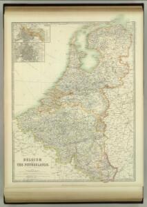
Belgium and the Netherlands
1 : 789237 Johnston, W. & A.K.
Niederlande, Belgien, Luxemburg
Hand-Atlas über alle Theile der Erde nach dem neuesten Zustande und über das Weltgebäude Stieler, Adolf bei Justus Perthes
Niederlande und Belgien
Handatlas über alle Theile der Erde und über das Weltgebäude Stieler, Adolf Justus Perthes
Holland, Belgium, and Switzerland.
1 : 1360000 Johnson, A.J.
[Niederlande, Belgien, Luxemburg]
Hand-Atlas über alle Theile der Erde nach dem neuesten Zustande und über das Weltgebäude Stieler, Adolf bei Justus Perthes
Niederlande und Belgien
Hand-Atlas über alle Theile der Erde und über das Weltgebäude Stieler, Adolf Justus Perthes
Hollande et Belgique.
1 : 1330000 Monin, C.V.
Holland and Belgium.
1 : 1290000 Colton, G.W.
Holland, Belgium.
1 : 770000 Arrowsmith, John
Belgium, Netherlands, Luxembourg. Pergamon World Atlas.
Polish Army Topography Service
Netherlands.
1 : 1237000 Teesdale, Henry
Belgium and the Netherlands
1 : 789237 Johnston, Alexander Keith
Holland & Belgium.
1 : 792000 Arrowsmith, John
Belgium and the Netherlands
1 : 789237 Johnston, Alexander Keith
Nieuwe kaart van het Koningryk der Nederlanden en het Groot-hertogdom Luxemburg
1 : 600000 Belgie Weygand, F. J. Baarsel, Cornelis van
Holland and Belgium.
1 : 4000000 Colton, G.W.
Pays-Bas et Belgique.
1 : 1180000 Migeon, J.
Belgique, Hollande, Limbourg, Luxembourg.
1 : 1000000 Picquet, C.
Carte du Royaume des Pays-Bas.
1 : 1360000 Vivien de St Martin, L.
Les sept provinces unies des Pay-Bas, ou la Hollande, avec les Pay-Bas Autrichiens
1 : 1480000 Nizozemsko Bonne, Rigobert André
Holland And Belgium.
1 : 1187000 Johnson, A.J.
Belgique et de Hollande, 1812.
1 : 3500000 Malte-Brun, Conrad, 1775-1826
Belgium, Netherlands, Luxembourg. Pergamon World Atlas.
Polish Army Topography Service
The Kingdom of the Netherlands
1 : 1500000 engraved by J. & C. Walker. London : Baldwin & Cradock
Holland and Belgium.
1 : 1330560 Colton, G.W.
44. Belgio e Olanda.
1 : 1500000 Touring club italiano
Niederlande Und Belgien.
1 : 1110000 Vogel, C.
Království Hollandské (Nizozemsko), Království Belgické
Belgie Hynek Fuchs
Regni di Olanda e del Belgio, e Gran Ducato di Luembourg.
1 : 1010000 Marzolla, Benedetto