Maps of Netherlands

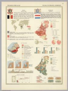
Belgium, Netherlands, Luxembourg. Pergamon World Atlas.
Polish Army Topography Service
Belgium, Netherlands, Luxembourg. Pergamon World Atlas.
Polish Army Topography Service
Holland, Belgium, and Switzerland.
1 : 1360000 Johnson, A.J.
Karte der Niederlande
1 : 980000 Belgie C. Hennigs Verlag
Karte der Niederlande
1 : 1000000 Belgie C. Hennig
Království Hollandské (Nizozemsko), Království Belgické
Belgie Hynek Fuchs
Kingdom of the Netherlands, including the Grand duchy of Luxembourg
1 : 740000 Belgie Wyld, James Ja.s Wyld
Netherlands.
1 : 1237000 Teesdale, Henry
Belgique, Hollande, Limbourg, Luxembourg.
1 : 1000000 Picquet, C.
Niederlande, Belgien und Luxemburg
1 : 600000 Belgie Carl Flemming u. C.T. Wiskott
Carte du Royaume des Pays-Bas.
1 : 1360000 Vivien de St Martin, L.
Belgique et de Hollande, 1812.
1 : 3500000 Malte-Brun, Conrad, 1775-1826
Netherlands, Belgium, and Luxemburg.
1 : 1287000 Hammond, C.S.
Holland, Belgium.
1 : 770000 Arrowsmith, John
Belgium and the Netherlands
1 : 789237 Johnston, W. & A.K.
Holland Or The Seven United Provinces, And The Netherlands.
1 : 1250000 Carey, Mathew
Holland Or The Seven United Provinces, And The Netherlands.
1 : 1200000 Carey, Mathew
The Kingdom of the Netherlands
1 : 1500000 engraved by J. & C. Walker. London : Baldwin & Cradock
Pays-Bas et Belgique.
1 : 1180000 Migeon, J.
44. Belgio e Olanda.
1 : 1500000 Touring club italiano
Holland and Belgium.
1 : 1110000 Sharpe, J.
Regni di Olanda e del Belgio, e Gran Ducato di Luembourg.
1 : 1010000 Marzolla, Benedetto
Nieuwe kaart van het Koningryk der Nederlanden en het Groot-hertogdom Luxemburg
1 : 600000 Belgie Weygand, F. J. Baarsel, Cornelis van
Niederlande, Belgien, Luxemburg
Hand-Atlas über alle Theile der Erde nach dem neuesten Zustande und über das Weltgebäude Stieler, Adolf bei Justus Perthes
Holland and Belgium.
1 : 1300000 Colton, G.W.
Hollande et Belgique.
1 : 1330000 Monin, C.V.
Niederlande und Belgien
Hand-Atlas über alle Theile der Erde und über das Weltgebäude Stieler, Adolf Justus Perthes
Niederlande und Belgien
Handatlas über alle Theile der Erde und über das Weltgebäude Stieler, Adolf Justus Perthes
[Kaart], uit: Orandakoku zenzu / Senseki Takami
1 : 600000 Annotatie: Facs. van de uitg.: Furukawa : Kakindō, 1850; Lit.: The world in Japanese maps until the mid-19th century, p. 207; Annotatie geografische gegevens: West boven Takami, Senseki [Tokyo : Noma Kakagu Igaku Kenyu Shiryokan]