Maps of Netherlands

Holland & Belgium.
1 : 792000 Arrowsmith, John
Nieuwe kaart van het Koningrijk der Nederlanden en het Groot-Hertogdom Luxemburg, benevens geheel België : verdeeld in provincien volgens de jongste bepalingen, verrijkt met de post & andere groote wegen
1 : 1000000 zamengest. & gegraveerd door W.C. van Baarsel. Te Zalt-Bommel : bij Joh. Noman en Zoon
Das Koenigreich der Niederlande nebst dem Grossherzogthume Luxemburg
1 : 925000 Belgie Weiland, Karl Ferdinand Geographisches Institut
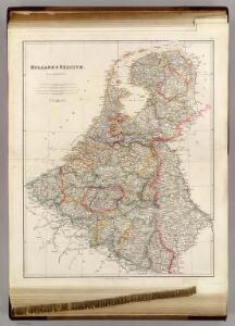
Holland and Belgium.
1 : 1110000 Sharpe, J.
Belgique et de Hollande, 1812.
1 : 3500000 Malte-Brun, Conrad, 1775-1826
Pays-Bas, Belgique, Luxembourg.
1 : 1000000 Levasseur, E.
Netherlands.
1 : 1237000 Teesdale, Henry
Belgium And Holland.
1 : 1500000 Greenleaf, Jeremiah
Belgium And Holland.
1 : 1500000 Greenleaf, Jeremiah

Das Königreich der Niederlande. Das Königreich Belgien und das Grossherzogthum Luxemburg

Pays-Bas et Belgique.
1 : 1180000 Migeon, J.
Niederlande und Belgien
Hand-Atlas über alle Theile der Erde und über das Weltgebäude Stieler, Adolf Justus Perthes
Niederlande und Belgien
Handatlas über alle Theile der Erde und über das Weltgebäude Stieler, Adolf Justus Perthes
Belgium and Holland.
1 : 1500000 Schonberg & Co.
Holland and Belgium.
1 : 4000000 Colton, G.W.
[Niederlande, Belgien, Luxemburg]
Hand-Atlas über alle Theile der Erde nach dem neuesten Zustande und über das Weltgebäude Stieler, Adolf bei Justus Perthes
Pays-Bas.
1 : 1000000 Brue, Adrien Hubert, 1786-1832
Niederlande, Belgien, Luxemburg
Hand-Atlas über alle Theile der Erde nach dem neuesten Zustande und über das Weltgebäude Stieler, Adolf bei Justus Perthes
Holland, Belgium.
1 : 770000 Arrowsmith, John
Holland and Belgium.
1 : 1330560 Colton, G.W.
Holland And Belgium.
1 : 1187000 Johnson, A.J.
44. Belgio e Olanda.
1 : 1500000 Touring club italiano
Niederlande Und Belgien.
1 : 1110000 Vogel, C.
Das Königreich der Niederlande, das Königreich Belgien und das Groszherzogthum Luxemburg
1 : 950000 entworfen und gezeichnet von C.F. Weiland. Weimar : im Verlage des Geogr. Instituts
Holland and Belgium.
1 : 1290000 Colton, G.W.
Netherlands, Belgium.
1 : 1170000 Society for the Diffusion of Useful Knowledge (Great Britain)
Karte der Niederlande
1 : 980000 Belgie C. Hennigs Verlag
Karte der Niederlande
1 : 1000000 Belgie C. Hennig