Maps of Netherlands

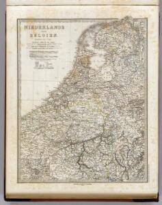
Niederlande Und Belgien.
1 : 1110000 Vogel, C.
Holland and Belgium.
1 : 4000000 Colton, G.W.
Holland And Belgium.
1 : 1187000 Johnson, A.J.
Pays-Bas et Belgique.
1 : 1180000 Migeon, J.
Holland and Belgium.
1 : 1330560 Colton, G.W.
Netherlands, Belgium.
1 : 1170000 Society for the Diffusion of Useful Knowledge (Great Britain)
44. Belgio e Olanda.
1 : 1500000 Touring club italiano
Belgium, Netherlands.
1 : 1140480 Letts, Son & Co.
Nieuwe kaart van het Koningrijk der Nederlanden en het Groot-Hertogdom Luxemburg, benevens geheel België : verdeeld in provincien volgens de jongste bepalingen, verrijkt met de post & andere groote wegen
1 : 1000000 zamengest. & gegraveerd door W.C. van Baarsel. Te Zalt-Bommel : bij Joh. Noman en Zoon
Belgique et de Hollande, 1812.
1 : 3500000 Malte-Brun, Conrad, 1775-1826
Belgique, Hollande, Limbourg, Luxembourg.
1 : 1000000 Picquet, C.
Neueste Karte von Holland, Belgien und Luxemburg
Grosser Hand-Atlas über alle Theile der Erde in 170 Karten Meyer, J. Verlag des Bibliographischen Instituts
[Niederlande, Belgien, Luxemburg]
Hand-Atlas über alle Theile der Erde nach dem neuesten Zustande und über das Weltgebäude Stieler, Adolf bei Justus Perthes
Holland & Belgium.
1 : 950400 Fullarton, A. & Co.
Niederlande und Belgien
Hand-Atlas über alle Theile der Erde und über das Weltgebäude Stieler, Adolf Justus Perthes
Les sept provinces unies des Pay-Bas, ou la Hollande, avec les Pay-Bas Autrichiens
1 : 1480000 Nizozemsko Bonne, Rigobert André
Holland and Belgium.
1 : 1290000 Colton, G.W.
Holland and Belgium.
1 : 1290000 Colton, G.W.
Niederlande und Belgien
Handatlas über alle Theile der Erde und über das Weltgebäude Stieler, Adolf Justus Perthes
Holland & Belgium.
1 : 792000 Arrowsmith, John
Niederlande, Belgien, Luxemburg
Hand-Atlas über alle Theile der Erde nach dem neuesten Zustande und über das Weltgebäude Stieler, Adolf bei Justus Perthes
Das Königreich der Niederlande, das Königreich Belgien und das Groszherzogthum Luxemburg
1 : 950000 entworfen und gezeichnet von C.F. Weiland. Weimar : im Verlage des Geogr. Instituts
Netherlands.
1 : 1237000 Teesdale, Henry
[Neuer Atlas der ganzen Erde nach den neuesten Bestimmungen ... : X.] Die Königreiche der Niederlande und Belgien
Entworfen und gezeichnet von Dr. F.W. Streit H. Leutemann sc. Leipzig : J.C. Hinrichssche Buchhandlung
Holland, Belgium.
1 : 770000 Arrowsmith, John
Das Koenigreich der Niederlande nebst dem Grossherzogthume Luxemburg
1 : 925000 Belgie Weiland, Karl Ferdinand Geographisches Institut
The Kingdom of the Netherlands
1 : 1500000 engraved by J. & C. Walker. London : Baldwin & Cradock
Tableau l'historie des Royaumes de Belgique et de Hollande.
1 : 3200000 Duval, Henri
Nieuwe kaart van het Koningryk der Nederlanden en het Groot-hertogdom Luxemburg
1 : 600000 Belgie Weygand, F. J. Baarsel, Cornelis van