Maps of Netherlands

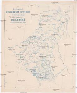
Království Hollandské (Nizozemsko), Království Belgické
Belgie Hynek Fuchs
The Kingdom of the Netherlands
1 : 1500000 engraved by J. & C. Walker. London : Baldwin & Cradock
Karte der Niederlande
1 : 980000 Belgie C. Hennigs Verlag
Karte der Niederlande
1 : 1000000 Belgie C. Hennig
Netherlands.
1 : 1237000 Teesdale, Henry
44. Belgio e Olanda.
1 : 1500000 Touring club italiano
Belgique, Hollande, Limbourg, Luxembourg.
1 : 1000000 Picquet, C.
Niederlande, Belgien und Luxemburg
1 : 600000 Belgie Carl Flemming u. C.T. Wiskott
Pays-Bas, Belgique, Luxembourg.
1 : 1000000 Levasseur, E.
Nieuwe kaart van het Koningryk der Nederlanden en het Groot-hertogdom Luxemburg
1 : 600000 Belgie Weygand, F. J. Baarsel, Cornelis van
Holland and Belgium.
1 : 1290000 Colton, G.W.
Holland and Belgium.
1 : 1110000 Sharpe, J.
Holland, Belgium, and Switzerland.
1 : 1360000 Johnson, A.J.
Regni di Olanda e del Belgio, e Gran Ducato di Luembourg.
1 : 1010000 Marzolla, Benedetto
Belgium, Netherlands, Luxembourg. Pergamon World Atlas.
Polish Army Topography Service
Belgique et de Hollande, 1812.
1 : 3500000 Malte-Brun, Conrad, 1775-1826
Holland, Belgium.
1 : 770000 Arrowsmith, John
Belgium, Netherlands, Luxembourg. Pergamon World Atlas.
Polish Army Topography Service
The Kingdom of the Netherlands
1 : 1495000 Belgie Walker, C. Baldwin & Gradock
Niederlande, Belgien, Luxemburg
Hand-Atlas über alle Theile der Erde nach dem neuesten Zustande und über das Weltgebäude Stieler, Adolf bei Justus Perthes
[Kaart], uit: Orandakoku zenzu / Senseki Takami
1 : 600000 Annotatie: Facs. van de uitg.: Furukawa : Kakindō, 1850; Lit.: The world in Japanese maps until the mid-19th century, p. 207; Annotatie geografische gegevens: West boven Takami, Senseki [Tokyo : Noma Kakagu Igaku Kenyu Shiryokan]
Niederlande und Belgien
Handatlas über alle Theile der Erde und über das Weltgebäude Stieler, Adolf Justus Perthes
Carte du Royaume des Pays-Bas.
1 : 1360000 Vivien de St Martin, L.
Pays-Bas et Belgique.
1 : 1180000 Migeon, J.
Niederlande und Belgien
Hand-Atlas über alle Theile der Erde und über das Weltgebäude Stieler, Adolf Justus Perthes
[Niederlande, Belgien, Luxemburg]
Hand-Atlas über alle Theile der Erde nach dem neuesten Zustande und über das Weltgebäude Stieler, Adolf bei Justus Perthes
Kingdom of the Netherlands, including the Grand duchy of Luxembourg
1 : 740000 Belgie Wyld, James Ja.s Wyld
Das Koenigreich der Niederlande nebst dem Grossherzogthume Luxemburg
1 : 925000 Belgie Weiland, Karl Ferdinand Geographisches Institut
Belgium and Holland.
1 : 1500000 Schonberg & Co.