Maps of Netherlands

Holland and Belgium.
1 : 1290000 Colton, G.W.
Niederlande und Belgien
Hand-Atlas über alle Theile der Erde und über das Weltgebäude Stieler, Adolf Justus Perthes
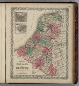
Holland and Belgium.
1 : 4000000 Colton, G.W.
Niederlande und Belgien
Handatlas über alle Theile der Erde und über das Weltgebäude Stieler, Adolf Justus Perthes
[Niederlande, Belgien, Luxemburg]
Hand-Atlas über alle Theile der Erde nach dem neuesten Zustande und über das Weltgebäude Stieler, Adolf bei Justus Perthes
Holland And Belgium.
1 : 1187000 Johnson, A.J.
Holland, Belgium.
1 : 770000 Arrowsmith, John
Niederlande, Belgien, Luxemburg
Hand-Atlas über alle Theile der Erde nach dem neuesten Zustande und über das Weltgebäude Stieler, Adolf bei Justus Perthes
Niederlande Und Belgien.
1 : 1110000 Vogel, C.
Netherlands.
1 : 1237000 Teesdale, Henry
Holland & Belgium.
1 : 792000 Arrowsmith, John
Belgium and the Netherlands
1 : 789237 Johnston, W. & A.K.
Pays-Bas et Belgique.
1 : 1180000 Migeon, J.
Belgique, Hollande, Limbourg, Luxembourg.
1 : 1000000 Picquet, C.
Belgique et de Hollande, 1812.
1 : 3500000 Malte-Brun, Conrad, 1775-1826
The Kingdom of the Netherlands
1 : 1500000 engraved by J. & C. Walker. London : Baldwin & Cradock
Holland and Belgium.
1 : 1330560 Colton, G.W.
44. Belgio e Olanda.
1 : 1500000 Touring club italiano
Holland and Belgium.
1 : 1110000 Sharpe, J.
Hollande et Belgique.
1 : 1330000 Monin, C.V.
Nieuwe kaart van het Koningrijk der Nederlanden en het Groot-Hertogdom Luxemburg, benevens geheel België : verdeeld in provincien volgens de jongste bepalingen, verrijkt met de post & andere groote wegen
1 : 1000000 zamengest. & gegraveerd door W.C. van Baarsel. Te Zalt-Bommel : bij Joh. Noman en Zoon
Nieuwe kaart van het Koningryk der Nederlanden en het Groot-hertogdom Luxemburg
1 : 600000 Belgie Weygand, F. J. Baarsel, Cornelis van
Holland, Belgium, and Switzerland.
1 : 1360000 Johnson, A.J.
Karte der Niederlande
1 : 980000 Belgie C. Hennigs Verlag
Karte der Niederlande
1 : 1000000 Belgie C. Hennig
Holland & Belgium.
1 : 950400 Fullarton, A. & Co.
Belgium and the Netherlands
1 : 789237 Johnston, Alexander Keith
Království Hollandské (Nizozemsko), Království Belgické
Belgie Hynek Fuchs