Maps of Kirov

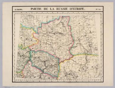
Partie, Russie d'Europe. Europe 11.
1 : 1641836 Vandermaelen, Philippe, 1795-1869
Bez titulu: Uržum a okolí

Karte der stroganowschen Erbländer
1 : 850000 Leipzig : Wilhelmi
Bez titulu: Slobodskoj a okolí

Geologische Karte des Hüttenbezirks Wotkinsk |i Geologische Karte des Hüttenbzirks Perm
1 : 210000 Hofmann, E. Kartographische Anstalt A. Ilgin
[X], uit: Geognostische Karte des Oesterreichischen Kaiserstaates mit einem grossen Theile Deutschland's u. Italien / hauptsachlich nach ... Haidinger's geognostischer Karte dieses Staates bearb. von Josef Scheda
1 : 3000000 titelvariant: General-Karte von Europa in 25 Blättern; Annotatie: Bijlage bij: General-Karte von Europa in 25 Blättern. - 1:2.592.000. - 1845-1847 Scheda, Joseph Wien : K.K. Militär. Geografisch. Institut
Ost-Europa, No. 4: Central-Russland.
1 : 3700000 Petermann, A.
Feuille 20 (F III), uit: Carte géologique internationale de l'Europe : la carte, votée au congrès géologique international de Bologne en 1881, est exécutée conformément aux décisions d'une commission internationale, avec le concours des gouvernements, sous le dir. de M.M. Beyrich et Hauchecorne
Annotatie: Blad 48 gamme des couleurs; blad 49: bladwijzer en titelblad Heinrich Ernst Beyrich 1815-1896; Wi. Hauchecorne Berlin : Reimer / (Berlin: Institut lithographique)
Schema historických momentů československ. vojenských operací na Sibiři 1918-1919
Karte vom Ural Gebirge, gegründet auf die astronomischen Beobachtungen von Wischnewsky, Schubert, A. v. Humboldt, Ad. Erman, und auf handschriftliche Specialkarten
1 : 2000000 [S.l.] : [s.n.]
U.S.S.R. in Europe - Central. Pergamon World Atlas.
1 : 2500000 Polish Army Topography Service
Feuille 13 (F II), uit: Carte géologique internationale de l'Europe : la carte, votée au congrès géologique international de Bologne en 1881, est exécutée conformément aux décisions d'une commission internationale, avec le concours des gouvernements, sous le dir. de M.M. Beyrich et Hauchecorne
Annotatie: Blad 48 gamme des couleurs; blad 49: bladwijzer en titelblad Heinrich Ernst Beyrich 1815-1896; Wi. Hauchecorne Berlin : Reimer / (Berlin: Institut lithographique)
Voenno-dorožnaja karta časti Rossii i pograničnych zemelʹ
1 : 1680000 Zentralrussland, Moskau Šubert [Generalmajor]
NOVA & ACCVRATA | WOLGÆ FLVMINIS
olim RHA dicti, | DELINEATIO | Auctore | ADAMO OLEARIO. [Amsterdam : Joan Blaeu]
Nova Et Accurata Wolgae Fluminis, olim RHA dicti Delineatio [Karte, Teil 1], in: Novus atlas absolutissimus, Bd. 1, S. 87.
1 Karte aus Atlas Janssonius Offizin
Otčetnaja karta pochoda Īoanna Groznago pod Kazan' v 1552 g.
Russland Khanat Kasan Kasan Krieg Iwan IV.
Geologičeskaja karta Evropejskoj Rossii
1 : 2500000 Ostblatt Karpinskij, A.P. (Aleksandr Petrovič) Kartografičeskoe zavedenie A.Il'ina
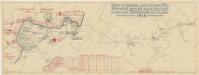
Friedensdislokation im europäischen Russland
1 : 2800000 Rusko západní
(Europaischen Russland II).
1 : 5000000 Berghaus, Heinrich; Flemming, Carl; Handtke, Friedrich H.; Sohr, Karl
Zweiter Theil der Karte von Europa welcher Dænemark, und Norwegen, Schweden, und Russland enthælt, 1
1 Blatt : 72 x 53 cm F.A. Schrämbl
Seconde partie de la carte d'Europe contenant le Danemark et la Norwege, la Suède et la Russie (a l'exeption de l'Ukraine), 1
1 Blatt : 71 x 53 cm chez l'auteur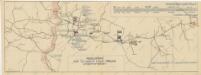
Schema historických momentů československ. vojenských operací na Sibiři 1918-1919
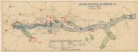
Schema historických momentů československ. vojenských operací na Sibiři 1918-1919
Tabula Moscoviae / nunc accuratius concinnata et edita a Petro Schenk ; par G. de l'Isle geographe
1 : 2650000 1 Karte auf 2 Blatt : Kupferdruck ; 48 x 60 cm je Kartenblatt Schenk, Pieter chez Pierre Schenk, avec priv.
Schema historických momentů československ. vojenských operací na Sibiři 1918-1919

Composite: Moscovie.
1 : 2600000 L'Isle, Guillaume de, 1675-1726
Carte generale de toute l'Europe, 3
1 Blatt : 57 x 48 cm J.M. Will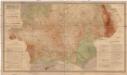
Gipsometričeskaja karta Jevropejskoj Rossii
1 : 2500000 Rusko západní Tillo, Alexis Kartografičeskoje zavedenije A. Il'jina