Maps of Komi

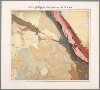
Feuille 13 (F II), uit: Carte géologique internationale de l'Europe : la carte, votée au congrès géologique international de Bologne en 1881, est exécutée conformément aux décisions d'une commission internationale, avec le concours des gouvernements, sous le dir. de M.M. Beyrich et Hauchecorne
Annotatie: Blad 48 gamme des couleurs; blad 49: bladwijzer en titelblad Heinrich Ernst Beyrich 1815-1896; Wi. Hauchecorne Berlin : Reimer / (Berlin: Institut lithographique)
Dwinae fluvii nova descripto
1 : 637000 Janssonius van Waesberge, Johannes Pitt, Moses Mosis Pitt
Dwinae fluvii nova descripto
1 : 637000 Janssonius, Johannes apud Joannem Janßonium
Partie, Russie d'Europe. Europe 6.
1 : 1641836 Vandermaelen, Philippe, 1795-1869
Partie, Russie d'Europe. Europe 11.
1 : 1641836 Vandermaelen, Philippe, 1795-1869
Karte der stroganowschen Erbländer
1 : 850000 Leipzig : Wilhelmi
Dwinae Fluvii. nova descriptio. [Karte, Teil 2], in: Novus atlas absolutissimus, Bd. 1, S. 81.
1 Karte aus Atlas Janssonius Offizin
Bez titulu: Slobodskoj a okolí

Bez titulu: Uržum a okolí

Geologische Karte des Hüttenbezirks Goroblagodatsk
1 : 210000 Hofmann, E. Kartographische Anstalt A. Ilgin
Geologische Karte des Hüttenbezirks Wotkinsk |i Geologische Karte des Hüttenbzirks Perm
1 : 210000 Hofmann, E. Kartographische Anstalt A. Ilgin
Geologische Karte des Hüttenbezirks Bogoslowsk
1 : 210000 Hofmann, E. Kartographische Anstalt A. Ilgin
Geologische Karte des Hüttenbezirks Katharinenburg
1 : 210000 Hofmann, E. Kartographische Anstalt A. Ilgin
(Europaischen Russland II).
1 : 5000000 Berghaus, Heinrich; Flemming, Carl; Handtke, Friedrich H.; Sohr, Karl
Russie Europeenne sud.
1 : 3350000 Robert de Vaugondy, Gilles, 1688-1766

Des europäischen Russlands nördlicher Theil
Allgemeiner Atlas [Walch, Johannes] im Verlag bei Johannes Walch

Karta Pomorskago kraja v 17 věkě
Russland Russland (Nord)
Russia 2.
1 : 4435200 Letts, Son & Co.
Russia in Europe. Part II.
1 : 4500000 Society for the Diffusion of Useful Knowledge (Great Britain)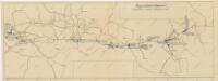
Schema historických momentů československ. vojenských operací na Sibiři 1918-1919

Governo di Arcangelo, e sue provincie nella Russia europea / G. Zuliani inc. ; G. Pitteri scr
1 : 3500000 1 Karte : Kupferdruck ; 42 x 33 cm Zuliani, Giuliano presso Antonio Zatta
Russie européenne; partie septentrionale / Tardieu sculp. ; André scrip
1 : 5300000 1 Karte : Kupferdruck ; 31 x 41 cm Mentelle, Edme [Mentelle]
[Ost-Europa in 6 Blättern, Enthaltend: Norwegen, Schweden, Russland, Kaukasien und die Türkei, Blatt 2]
Hand-Atlas über alle Theile der Erde und über das Weltgebäude Stieler, Adolf Justus Perthes
[V], uit: Geognostische Karte des Oesterreichischen Kaiserstaates mit einem grossen Theile Deutschland's u. Italien / hauptsachlich nach ... Haidinger's geognostischer Karte dieses Staates bearb. von Josef Scheda
1 : 3000000 titelvariant: General-Karte von Europa in 25 Blättern; Annotatie: Bijlage bij: General-Karte von Europa in 25 Blättern. - 1:2.592.000. - 1845-1847 Scheda, Joseph Wien : K.K. Militär. Geografisch. Institut
Ost-Europa, Bl. 2: Nordost-Russland.
1 : 3700000 Petermann, A.
[Ost-Europa, Blatt 2]
Adolf Stieler's Handatlas über alle Theile der Erde und über das Weltgebäude Stieler, Adolf Justus Perthes
Geologičeskaja karta Evropejskoj Rossii
1 : 2500000 Nordost-Blatt Karpinskij, A.P. (Aleksandr Petrovič) Kartografičeskoe zavedenie A.Il'ina