Maps of Komi

Des europäischen Russlands nördlicher Theil
Allgemeiner Atlas [Walch, Johannes] im Verlag bei Johannes Walch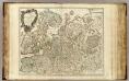
Russie Europeenne sud.
1 : 3350000 Robert de Vaugondy, Gilles, 1688-1766
Carte de La Russie D'Europe.
1 : 6700000 Vivien de St Martin, L.
Europe Orientale, Feuille Nord.
1 : 5000000 Vivien St Martin, L.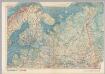
U.S.S.R. In Europe - North. Pergamon World Atlas.
1 : 5000000 Polish Army Topography Service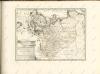
Carte des gîtes miniers de la Russie d'Europe
1 : 4200000 Nord-Blatt Möller, Valerian von Département des Mines de Russie
Russie d'Europe / par J.B. Poirson Ingénieur Géog.e
1 : 10000000 1 Karte : Kupferdruck ; 18 x 24 cm Poirson, Jean-Baptiste [Verlag nicht ermittelbar]
Carte de la Russie d'Europe / par J.B. Poirson ; gravé par Tardieu
1 : 9000000 1 Karte auf 2 Blatt : Kupferdruck ; 39 x 27 cm Poirson, Jean-Baptiste [Mentelle]
N. Russia in Europe.
1 : 9200000 Seaman, James V.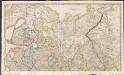
Russian Dominions
A new general atlas of modern geography, consisting of a complete collection of maps of the four quarters of the globe Wyld, James James Wyld
Eastern part of the northern states, including the eastern part of Sweden; European Russia, [et]c
1 Blatt : 54 x 68 cm Sayer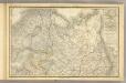
Das Russische Reich in Europa Nord.
1 : 4475000 Stein, Christ. Gottfr. Dan.
Russie européenne; partie septentrionale / Tardieu sculp. ; André scrip
1 : 5300000 1 Karte : Kupferdruck ; 31 x 41 cm Mentelle, Edme [Mentelle]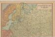
Evropské Rusko a Turecko
Kuchař, Karel
[Ost-Europa in 6 Blättern, Blatt 2]
Handatlas über alle Theile der Erde und über das Weltgebäude Stieler, Adolf Justus Perthes

Postkarte von Nord-Russland
Rusko severozápadní Benedict, Anton im von Reillyschen Landkarten und Kunstwerke Verschleiss Komptoir
Eur. Russland
Rusko severní
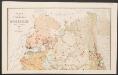
Karta Pomorskago kraja v 17 věkě
Russland Russland (Nord)
Russia 2.
1 : 4435200 Letts, Son & Co.
La Moscovia
1 : 15500000 Moskva-oblast (Rusko) Zatta, Antonio Zatta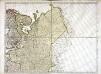
Karte von Europa, 2
4 Blätter : 52 x 70 cm Verlag der Königlich-Preussischen Academie-Kunst- und Buchhandlung
Russie d'Europe.
1 : 11400000 Delamarche, Charles Francois
[Ost-Europa in 6 Blättern, Enthaltend: Norwegen, Schweden, Russland, Kaukasien und die Türkei, Blatt 2]
Hand-Atlas über alle Theile der Erde und über das Weltgebäude Stieler, Adolf Justus Perthes
Partie septentrionale de la Russie européenne / par Robert de Vaugondy ; corrigée par le C.en Lama
1 : 7400000 1 Karte : Kupferdruck ; 23 x 30 cm Delamarche, Charles François [Verlag nicht ermittelbar]
Partie septentrionale de la Russie européenne / d'aprés le détail de l'Atlas Russien par le Sr. R
1 : 3400000 1 Karte auf 2 Blatt : Kupferdruck ; 47 x 58 cm Robert de Vaugondy, Didier [Verlag nicht ermittelbar]

Russia in Europe. Part II.
1 : 4500000 Society for the Diffusion of Useful Knowledge (Great Britain)


